| Above: Rain and wind hit a parking lot at Roberto Clemente Coliseum in San Juan, Puerto Rico, on September 20, 2017, during the passage of Hurricane Maria. More than 500 people evacuated to the coliseum, where pieces of the roof began to give way and leak at the height of the storm early Wednesday. Lydia Gonzalez told the Los Angeles Times that she watched in horror as the roof stretched and strained "like bubble gum,” but the roof held. Image credit: Hector Retamal/AFP/Getty Images. |
A flash flood emergency was in effect for the entire main island of Puerto Rico at midday Thursday, as rainbands feeding into Hurricane Maria continued to stream north across the U.S. territory. Cat 3 Maria was centered more than 150 miles northwest of Puerto Rico at 11 am EDT. Intense rainbands extending well south of Maria’s center were lashing most of the Dominican Republic and parts of Puerto Rico. Power remains out across Puerto Rico on Thursday, and it may be weeks or months before widespread restoration of the island’s power grid, which was already reeling from Hurricane Irma even before Maria struck. Widespread damage and flooding was also reported in the U.S. Virgin Islands, where a 24-hour curfew is in effect. At least 7 deaths have been confirmed in hard-hit Dominica, a toll expected to rise as rescuers work their way into remote parts of the island. Some 90% of the structures in Dominica are reported to be damaged or destroyed, and there has been massive loss of trees across the once-lush landscape. Two deaths in Guadelope and one death in Puerto Rico are also being attributed to Maria.
 |
| Figure 1. Flooded streets are seen in San Juan, Puerto Rico, on September 21, 2017 after the passage of Hurricane Maria. Image credit: Hector Retamal/AFP/Getty Images. |
Maria still drenching Puerto Rico and the Virgin Islands
Satellite imagery on Thursday morning showed that Maria was well-organized, with a large area of very intense thunderstorms surrounding a huge 45-mile-diameter eye. The Hurricane Hunters have not detected much change in Maria’s intensity since 2 am, with the pressure holding nearly steady at 959 – 960 mb, and the surface winds maintaining a low-end Category 3 velocity, 115 mph, as of 11 am EDT. Maria’s spiral bands were still pounding Puerto Rico and the Virgin Islands with heavy rains, and extreme flash flooding will continue to occur on those islands for much of the day. The same is true of northern and eastern parts of the Dominican Republic, where 8 – 16” of total rainfall is predicted. Maria’s spiral bands were also beginning to affect the southeast Bahamas and Turks and Caicos Islands, where NHC is predicting rainfall amounts of 8 – 16” from Maria. These islands can expect heavy rains to increase through the day and peak on Friday, when Maria makes its closest approach. These islands will be on the weaker (left front) side of Maria, but the islands closest to Maria are likely to see sustained winds near hurricane force and a dangerous storm surge of up to 9 – 12’.
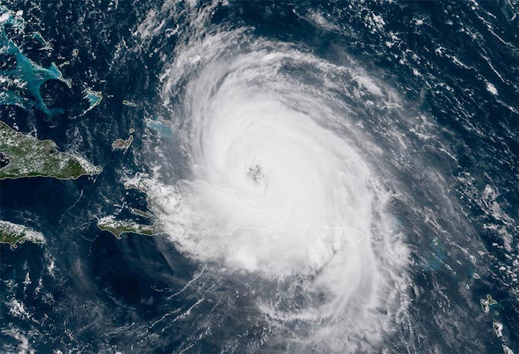 |
| Figure 2. Hurricane Maria as seen by the GOES-16 satellite at 10:45 am EDT September 21, 2017. Image credit: NOAA/RAMMB. GOES-16 data is considered preliminary and non-operational. |
#Maria may be weaker than it was 2 days ago, but the #GOES16 closeup of its eye is just as awesome pic.twitter.com/EhrvbgpNlN
— Dan Lindsey (@DanLindsey77) September 21, 2017
#Maria may be weaker than it was 2 days ago, but the #GOES16 closeup of its eye is just as awesome pic.twitter.com/EhrvbgpNlN
— Dan Lindsey (@DanLindsey77) September 21, 2017Forecast for Maria
Maria will be traversing very warm ocean waters with sea surface temperatures (SSTs) of around 29 - 29.5°C (84 - 85°F) through Monday. Part of the hurricane’s circulation was over Hispaniola on Thursday, though, which was blocking the inflow of moisture to the storm, and Maria was over waters with lower ocean heat content due to the passage of Hurricane Irma two weeks ago. On Friday, Maria will move off of Irma’s wake, and will have more ocean heat energy to work with; the hurricane will also be farther from interference by Hispaniola. This should allow for some modest intensification, perhaps to a low-end Category 4 storm with 130 mph winds, though our intensity forecast models are predicting only about a 5 – 10 mph increase in intensity. Wind shear will be a moderate 10 – 20 knots for the next five days, which should prevent any rapid intensification. By Monday, Maria’s circulation will pass over the cold wake left by Jose, and wind shear will increase to a moderately high 15 – 20 knots, which should be able to knock Maria down to Category 2 strength.
Maria will be steered northwest and eventually north over the next five days, around the edge of a high pressure system situated to its east. By Tuesday, Maria is expected to be a large Category 1 hurricane positioned several hundred miles east of the North Carolina coast, but the Outer Banks of North Carolina are clear of NHC’s 5-day cone of uncertainty. In the subsequent 5- to 7-day forecast range, there is more uncertainty than usual on how close Maria might get to the U.S. East Coast, since the hurricane’s track will depend upon how fast Jose decays, and where Jose moves. As Tropical Storm Jose weakens (see below), there is a slight possibility that the Atlantic ridge could build west and block Maria’s progress, forcing the storm to move to the north-northwest toward the coast between North Carolina and New Jersey. About 10% of the 50 ensemble members of the 0Z Thursday European model predicted a landfall in this region. A much more likely possibility is that a trough of low pressure passing to the north of Maria next week, in combination with the remains of Jose, will pull Maria to the east-northeast without the storm making landfall along the mid-Atlantic coast. In this case, though, Maria might still be a threat to the Canadian maritime provinces, and potentially Southeast Massachusetts. Maria would most likely be at tropical storm strength in this scenario, due to the cool waters north of North Carolina.
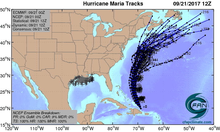 |
| Figure 3. The 20 track forecasts for Maria from the 0Z Thursday, September 21, 2017 GFS model ensemble forecast. The GFS gives the U.S. a clean pass, though 3 of the tracks show a Canada landfall. Image credit: CFAN. |
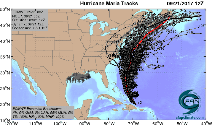 |
| Figure 4. The 0Z Thursday, September 21, 2017, track forecast by the operational European model for Maria (red line, adjusted by CFAN using a proprietary technique that accounts for storm movement since 0Z), along with the track of the average of the 50 members of the European model ensemble (heavy black line), and the track forecasts from all 50 members of the ensemble. About 60% of the forecasts show a Canada landfall, with 20% predicting a U.S. landfall, and 20% no landfall at all. Image credit: CFAN. |
What next?
Mercifully, the rest of the Atlantic is quiet, with NHC highlighting just one area with a 10% chance of development in their Five-Day Tropical Weather Outlook—the remains of Tropical Storm Lee. Ex-Lee is in the Central Atlantic, far from any land areas, and is not likely to develop because of high wind shear.
The Atlantic has been in a rare stretch of high activity—according to Dr. Phil Klotzbach, the Atlantic has had at least one active named storm for 28 consecutive days, the longest such period since 1995. We are due for a break, and the last few runs from the GFS model have not been depicting any new Atlantic tropical storms forming through at least October 2. The peak part of hurricane season lasts through mid-October, though. In a typical season, we would expect to see at least two more named storms (including one hurricane) form during the first three weeks of October, and perhaps another hurricane before the season ends on November 30. This year looks primed to be more active than usual in October and November, as a La Niña-like pattern—with cooler-than-average sea surface temperatures (SSTs) already present in the eastern tropical Pacific—may help keep wind shear in the tropical Atlantic below average.
In particular, the Western Caribbean will be an area we need to watch, as lower-than-average surface pressures are expected there during the first week of October. There is very high oceanic heat content in the western Caribbean to support hurricane development, and SSTs are running 1 - 2°C (2 - 4°F) above average.
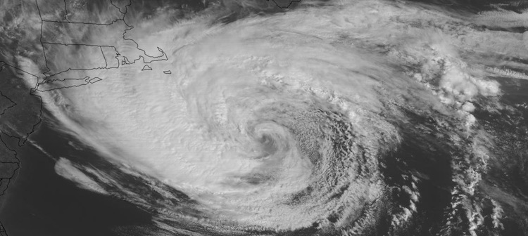 |
| Figure 5. Visible GOES-16 satellite image of Hurricane Jose at 10:32 am EDT Thursday, September 21, 2017. Image credit: NASA/MSFC Earth Science Branch. |
Jose holding firm south of New England
Tropical Storm Jose is now in its 17th day as a named tropical cyclone, and it may squeeze out one more day before going post-tropical. Centered about 145 miles southeast of Nantucket, MA, as of 11 am EDT Thursday, Jose was holding stationary while maintaining top sustained winds of 60 mph. A tropical storm warning continued for parts of far southeast New England. Sustained tropical-storm-force winds have been scarce to nonexistent over land, but Nantucket gusted to 48 mph early Thursday, and gusts of 40 – 45 mph have been common across Long Island, New York; southern Connecticut; and southeast Massachusetts. Rainfall has been mostly less than 1”, although the Taunton, MA, airport picked up 1.64” on Wednesday. Rip currents and big waves continue to gouge beaches from the Carolinas to New England. A 16-foot swell was recorded at buoy 44008 southeast of Nantucket, MA, and tides at Atlantic City, NJ, and Ocean City, MD, were running close to a foot above normal on Thursday morning. Parts of the oceanfront at North Wildwood, NJ, could be closed for two months in order to repair major beach erosion caused by Jose’s high surf.
Jose’s decline will accelerate from Thursday into Friday. Cool sea surface temperatures of around 22°C (72°F) and a dry atmosphere (midlevel relative humidity around 40%) will further erode Jose’s ability to maintain the showers and thunderstorms needed for a tropical cyclone. Wind shear is only moderate (10 – 15 knots), and it will take time for Jose’s expansive wind field to spin down, but NHC predicts Jose will be a post-tropical cyclone by Friday and a remnant low by Sunday. Very weak steering currents will allow Jose to deteriorate in place: NHC’s 3-day forecast puts Jose only about 40 miles away from its current location.
Weak as it is, Jose may be helping to protect the U.S. East Coast from Maria. Jose’s presence has kept a zone of lower pressure between two sprawling zones of upper-level high pressure, one over the eastern U.S. and the other across the Northwest Atlantic. Maria will be moving toward this weakness early next week, and this is likely to keep the hurricane east of the U.S. coast. Without Jose, it’s quite possible the two high-pressure zones would have merged and steered Maria directly into the southeast coast.
Bob Henson co-wrote this post.


