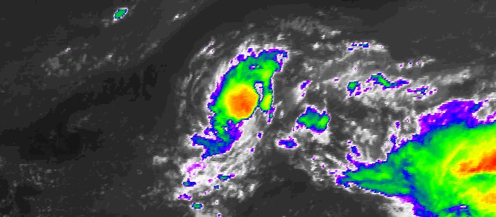
| Above: Infrared satellite image of Hurricane Maria at 12:27 pm EDT Saturday, September 23, 2017. Image credit: NASA/MSFC Earth Science Branch. |
Still a Category 3 storm on Saturday, Hurricane Maria was rolling northward away from the Bahamas on a path that could affect parts of the U.S. East Coast next week. Maria pummeled the Turks and Caicos Islands early Friday, its western eyewall passing over the capital city of Cockburn Town. For the first time in several days, Maria poses no immediate threat to land. At 11 am EDT Saturday, Maria was located about 320 miles east of Nassau, The Bahamas, moving north-northwest at 8 mph. Maria’s top sustained winds had dropped to 115 mph, putting it at the low end of the Category 3 range.
Maria was not a classically symmetric hurricane on Friday night, but its appearance on satellite had become dramatically stronger by midday Saturday. Very strong thunderstorms (convection) were wrapping around Maria’s ragged, 35-mile-wide eye. As is typically the case for hurricanes moving poleward, Maria’s wind field has been gradually expanding. Hurricane-force winds now extend up to 60 miles from Maria’s center, with tropical-storm-force winds extending out some 200 miles to the northeast of the center. Maria has been successfully fending off moderately strong wind shear of around 15 knots, with the help of its well-established structure as well as very warm sea surface temperatures (SSTs) of 29-30°C (84-86°F).
Threat from Maria to U.S. coast is increasing
The odds that the U.S. East Coast will see direct impacts from Maria next week have risen since Friday. Our leading track models for mature hurricanes—the UKMET, European, GFS, and HWRF models—agree that Maria will continue generally northward for the next five days. Importantly, though, each of these models has shifted westward in its projected path around the 4- to 6-day point, which means they are now predicting Maria could end up within 100 - 200 miles of the Outer Banks of North Carolina before a sharp eastward turn that will take it out to sea. (The Canadian global model, not typically one of the most reliable for hurricane prediction, was the first to sense this westward shift.)
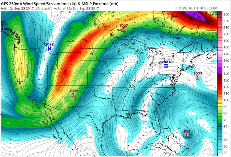
One key to the leftward trend is an upper-level low at high altitudes—above the 500-millibar level often used to diagnose steering currents—located across the Southeast U.S. (see Figure 1). Maria will make its way north between this low and upper-level ridging across the Northwest Atlantic. The upper low is predicted to become more compact and to move toward Florida early next week. Depending on the evolution of the upper low and on how quickly Maria moves, it’s possible that Maria could pivot around the northeast side of the upper low, which would give it a chance to approach the East Coast. Later next week, a stronger upper-level trough will cart Maria northeastward, away from the coast.
 |
| Figure 1. A weak upper-level trough over the southeast U.S., evident at the 250-mb level (about 34,000 feet) on Saturday morning, September 23, could play a role in the trajectory of Maria as it approaches the coast of the Carolinas next week. Image credit: tropicaltidbits.com. |
Along with these features, there is an expansive zone of upper-level high pressure north of Maria, bringing summer-like temperatures across much of the Northeast U.S. (One example: Burlington, VT—which has never seen autumn readings above 85°F later than September 23—is predicted to see all-time record heat for so late in the year, with highs approaching 90°F on Sunday through Tuesday.) This ridging across the Northeast and offshore will act as a brake on Maria’s forward speed. The five-day NHC position for Maria is only about 600 miles north of the hurricane’s current position, which would equate to an average forward speed of less than 10 mph.
If Maria moves more quickly than expected, it may have a better chance of pivoting around the Southeast upper low and nearing the Outer Banks ahead of its expected right-hand turn out to sea. In this case, the closest approach to North Carolina would come sooner—perhaps as soon as Wednesday, rather than Thursday or Friday, as suggested by some members of the European model ensemble. As shown below, about 30 - 40% of the GFS and Euro ensemble members from 0Z Saturday bring Maria into the U.S. East Coast, mainly across eastern North Carolina. A track just offshore still appears most likely, but at this point we cannot rule out the possibility of a U.S. landfall in the latter half of next week. Maria may go on to threaten parts of the Canadian Maritimes toward next weekend.
 |
| Figure 2. The 20 track forecasts for Maria from the 0Z Saturday, September 23, 2017 GFS model ensemble forecast. Image credit: CFAN. |
 |
| Figure 3. The 50 track forecasts for Maria from the 0Z Saturday, September 23, 2017 European model ensemble forecast. The operational European model is the red line, adjusted by CFAN using a proprietary technique that accounts for storm movement since 0Z Saturday. The track of the average of the 50 members of the European model ensemble is the heavy black line. Image credit: CFAN. |
At 11 am EDT Saturday, the National Hurricane Center adjusted its official prediction westward, putting extreme eastern North Carolina into the 5-day “cone of uncertainty.” Now is a good time to remember that the cone reflects typical track errors over the preceding five years of NHC forecasts. In order to minimize over- or under-warning, the cone is designed such that a given hurricane will fall within the cone about two out of three times—which means you can expect a given hurricane to be outside the cone about one of three times.
Uncertainty in the forecast for Maria may improve this weekend, especially with the help of two factors:
- Beginning Saturday afternoon, upper-air soundings will be collected at 2:00 am and pm from locations in the eastern and southeastern U.S.
- NOAA G-IV missions are scheduled to begin sampling the environment around Maria on Sunday.
Intensity forecast for Maria
Maria will continue to traverse very warm water over the weekend, with oceanic heat content high enough to reduce the chance of cooler water being upwelled. Wind shear will drop to around 10 knots, which together with the warm water will help give Maria a bump-up in strength, perhaps to the high-end Cat 3 or low-end Cat 4 range. As time goes by, greater parts of the circulation will be passing over the wake of cooler water left by Jose. This should produce a gradual weakening trend, although Maria is still expected to be a Category 1 hurricane on Thursday. Wind shear should be around 10 – 15 knots for most of next week, which is moderately strong but not enough to destroy a well-organized hurricane like Maria. If Maria’s path continues trending westward, it will keep more of the circulation over the warm Gulf Stream waters and away from Jose’s wake, which would help Maria to maintain more of its intensity.
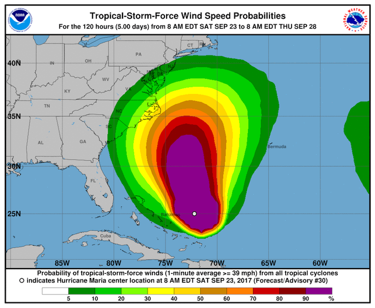
Regardless of Maria’s exact track, the hurricane is sure to bring a long period of increasing swells, dangerous surf, and rip currents to the Southeast U.S. coast, extending to the mid-Atlantic later next week. Significant beach erosion can be expected in and near the Outer Banks, given Maria’s strength and slow movement. There will also be an increasing chance of tropical-storm-force winds across parts of the U.S. East Coast by midweek (see Figure 4).
 |
| Figure 4. Probability of tropical-storm-force winds for the five days ending at 8 am Thursday, September 28, 2017. Image credit: NOAA/NWS/NHC. |
Tiny TS Lee is a bundle of uncertainty
Hurricane Maria is an open book compared with the mysteries of Tropical Storm Lee. The new incarnation of Lee sprang to life on Friday from the northern remnants of ex-Tropical Storm Lee. It appears that Lee 2.0 could go any number of directions in strength as well as movement. At 11 am EDT Saturday, Lee was positioned in the central North Atlantic about 900 miles east of Bermuda, drifting north at just 2 mph. Though Lee is a tiny system—tropical-storm-force winds extend out only 35 miles from its center—its small size gives it a greater potential to either intensify or weaken quickly.
Lee is moving into a zone of fairly light upper-level wind shear (5 to 10 knots), which should persist for the next couple of days. Moreover, Lee will benefit from unusually warm sea surface temperatures (about 1°C above average) as well as unusually cool upper-level temperatures (about 3°C below average). Together, these will enhance instability to help keep Lee’s showers and thunderstorms vigorous. The official NHC forecast at 11 am EDT Saturday brings Lee to hurricane strength by Tuesday. The HWRF and HMON intensity models make Lee a hurricane much more quickly—by Sunday. This is certainly possible with a storm as small as Lee in such favorable conditions, although the rapid intensification index of the 12Z Saturday SHIPS model gives only a small chance of such quick strengthening.
Lee will remain far from land throughout the five-day forecast period, wandering through weak steering currents. Over time, Lee is expected to carry out an anticyclonic loop that will keep it in the central North Atlantic for the foreseeable future.
 |
| Figure 5. Infrared satellite image of Tropical Storm Lee as of 12:15 pm EDT Saturday, September 23, 2017. Image credit: NOAA/NESDIS. |
 |
| Figure 6. Predicted precipitation for the 7-day period ending at 8 am Saturday, September 30, 2017. A moist flow of air associated with Invest 98E is expected to bring heavy rains to West Texas. Image credit: NOAA. |
Invest 98E a flood threat for Mexico and West Texas
In the Eastern Pacific, satellite images on Saturday afternoon showed that area of disturbed weather located about 100 miles southwest of Manzanillo, Mexico (98E) was bringing heavy rains to the coast of Southwest Mexico. Moisture associated with 98E will be streaming northwards into West Texas over the next week, leading to widespread heavy rains in excess of 5”. In their 8 am EDT Saturday Tropical Weather Outlook, NHC gave 98E 2-day and 5-day odds of development into a tropical depression of 90%.
Dr. Jeff Masters contributed to this post.


