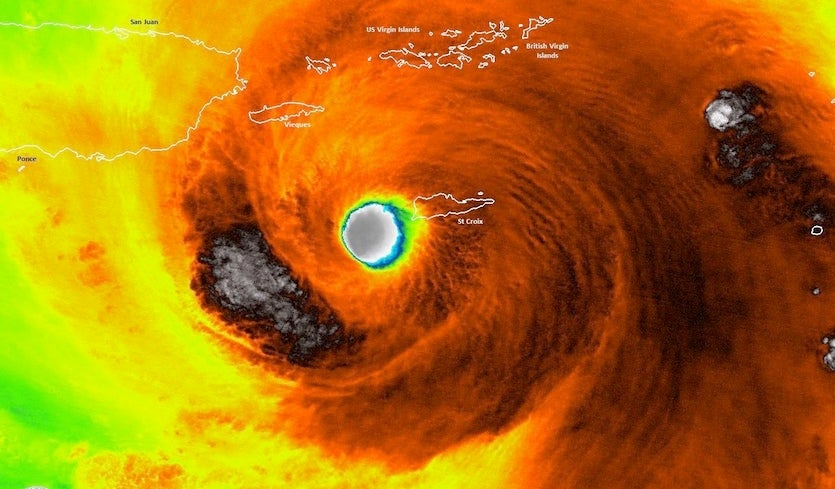
| Above: VIIRS infrared satellite image of Hurricane Maria moving just west of St. Croix while at Cat 5 strength at 2:13 am EDT Wednesday, September 20, 2017. Image credit: NOAA/CIMSS/UM-Madison. |
Ferocious Hurricane Maria made landfall around 6:15 am EDT Wednesday near Yabucoa in far southeast Puerto Rico as a top-end Category 4 storm, with peak sustained winds estimated at 155 mph.
Maria was the second strongest hurricane ever recorded to hit Puerto Rico, behind only the 1928 San Felipe Segundo hurricane, which killed 328 people on the island and caused catastrophic damage. Puerto Rico’s main island has also been hit by two other Category 4 hurricanes, the 1932 San Ciprian Hurricane, and the 1899 San Ciriaco Hurricane.
- In terms of top sustained wind, Maria is the fifth strongest hurricane on record to hit the U.S. behind only the four Cat 5s to hit the country (Hurricane Andrew of 1992 in South Florida, Hurricane Camille of 1969 in Mississippi, the Labor Day Hurricane of 1935 in the Florida Keys, and the 1928 hurricane in Puerto Rico).
- In terms of lowest atmospheric pressure at landfall, Maria (917 mb) ranks third in U.S. records behind only the 1935 Labor Day Hurricane and Camille.
- Maria's landfall at Category 4 strength gives the U.S. a record three Category 4+ landfalls this year (Maria, Harvey, and Irma). The previous record was two such landfalls, set in 1992 (Cat 5 Andrew in Florida, and Cat 4 Iniki in Hawaii.)
Maria did not hit Puerto Rico as a Category 5 hurricane, thanks to an eyewall replacement cycle (ERC) that began on Tuesday night. The storm’s “pinhole” eye, less than 10 miles wide, was supplemented by an outer eyewall that contracted around the smaller one. The process helped lead to the slight weakening of Maria’s top winds, but it also likely broadened its core of winds topping 100 mph.
Impact on St. Croix
Maria raked the U.S. Virgin Island of St. Croix (population 50,000) with its outer eyewall on the strong (right front) side of the eye, between about 1 – 3 am EDT Wednesday morning, but the island missed seeing the Category 5 winds of the inner eyewall, which remained just offshore to the south. The highest winds officially observed on the island were at Cotton Valley RAWS, located on the east end of St. Croix: sustained at 99 mph, gusting to 136 mph, at 2:13 am EDT. A WeatherFlow station at Sandy Point, on the island's southwest tip, observed sustained winds of 100-104 mph, gusting to 137 mph. Even stronger winds likely occurred somewhere across the island's west end, but we don’t know how strong, since the wind measuring equipment at the St. Croix airport and the Lime Tree Bay Buoy failed.
According to the Quicklook page at NOAA’s Tides and Currents, Christiansted Harbor on the north side of St. Croix observed a storm surge of two feet. The pressure at a personal weather station on the southwest tip of St. Croix fell to 954 mb at 1:48 am, when the eye made its closest pass to the island.
The British Virgin Islands and the other two U.S. Virgin Islands—St. John and St. Thomas—were far enough northeast to avoid the worst from Maria. A wind gust to 86 mph was reported at St. Thomas, according to weather.com.
 |
| Figure 1. The last radar image of Maria from the NWS Puerto Rico radar before it failed, taken at 5:45 am EDT Wednesday. Maria officially made landfall 30 minutes later at 6:15 am EDT, when the center of the eye crossed the coast. |
Maria in Puerto Rico
Yabucoa Harbor in southeast Puerto Rico, near where the center of Maria made landfall, recorded sustained winds of 71 mph gusting to 99 mph at 7:06 am EDT. A peak wind gust of 113 mph was observed there at 5:12 am. Other wind gusts across Puerto Rico as of early Wednesday morning, as compiled by weather.com, included:
- Isla Culebrita: 137 mph
- Camp Santiago: 118 mph
- El Negro: 116 mph
- Gurabo: 115 mph
- Yabucoa: 113 mph
- Fajardo: 100 mph
According to the Quicklook page at NOAA’s Tides and Currents, Yabucoa Harbor recorded a peak storm surge of approximately 5.3’ as of 8 am EDT Wednesday.
At 8 am EDT Wednesday, Maria was centered about 15 miles south-southwest of San Juan, PR, moving northwest at 10 mph. A sustained wind of 64 mph, gusting to 113, was reported at San Juan, Puerto Rico at 7 am, but the airport is no longer reporting winds. Maria will cut a destructive swath across Puerto Rico from southeast to northwest on Wednesday morning, with its center moving offshore from the north central coast by late morning. The mountainous terrain of Puerto Rico will disrupt Maria’s core, probably leaving the storm as a Category 3 by the time it moves back offshore midday Wednesday. Maria’s track is putting the dangerous right-hand side of Maria’s core over or near the San Juan metropolitan area.
Torrential rains will produce widespread flooding across Puerto Rico. NOAA/USGS gauge data showed that several rivers along the higher terrain of central and east central Puerto Rico were already close to record crests as of Wednesday morning. Jonathan Vigh (National Center for Atmospheric Research) noted that very heavy rainfall was observed by the NWS San Juan radar in the vicinity of the El Yunque rainforest, just east of San Juan, before the radar went out of service on Wednesday morning. He added that the region's 3000-foot-high mountains and a northeastward-facing valley were nearly ideal for intercepting hurricane-force winds blowing toward Maria's center.
We'll be back with a full update on Maria and Jose later today.
Jeff Masters co-wrote this post.
 |
| Figure 2. Before it went out of service at around 5:45 am EDT Wednesday, the NWS radar showed very heavy rainfall accumulations along the higher terrain of east central Puerto Rico. Totals of more than 25" were estimated in the vicinity of the El Yunque rainforest. |
 |
| Figure 3. First-light GOES-16 image of Hurricane Maria taken at 7:15 am EDT September 20, 2017. Maria's eye was obscured by clouds due to interactions with land. Image credit: NOAA/RAMMB. GOES-16 data is preliminary and considered non-operational. |
Eyewall Hurricane Maria in Puerto Rico !! https://t.co/G8GaLTmNqh
— Extreme Nature (@extremenature) September 20, 2017


