| Above: GOES-16 satellite image of Tropical Storm Maria (left) and Hurricane Lee (right) at 12:05 pm EDT Thursday, September 28, 2017. Image credit: RAMMB / CIRA @ CSU. GOES-16 imagery is considered preliminary and non-operational. |
Still close to hurricane strength on Thursday, Tropical Storm Maria was taking the first eastward turn in its 12 days as a named system, signaling a long-awaited recurvature that will take it away from land. With top sustained winds of 70 mph at 11 am EDT Thursday, Maria was located about 365 miles east-northeast of Cape Hatteras, heading east at 13 mph. All tropical storm and storm surge watches and warnings have been discontinued for the U.S. East Coast, and evacuation orders for tourists on Hatteras and Ocracoke islands were being lifted on Thursday. As Maria made its closest approach to the Outer Banks, winds gusted to as high as 55 mph at Oregon Inlet. Minor flooding was reported on side streets as well as on Highway 12, the main route linking the region’s islands. According to the NOAA Tides and Currents Quicklook page for Maria, a peak storm surge of 2.8’ was observed at Cape Hatteras, NC near 2 am EDT Wednesday.
Maria is not expected to regain hurricane strength, but its decline will be gradual over the next day or so. The storm has a large circulation, and it will be traveling over marginally warm waters (sea surface temperatures of 26-27°C or 79-81°F) in wind shear of less than 10 knots. By late Friday, Maria will be moving over cooler water and experiencing higher wind shear, and this will hasten its expected conversion into a post-tropical low over the weekend. Maria will be pushed east-northeast at an accelerating pace by a strong upper-level trough moving toward the North Atlantic (the same trough that’s now sweeping a historic record-warm air mass away from the Great Lakes).
 |
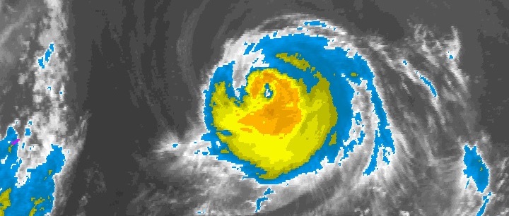
| Figure 1. Infrared image of Hurricane Lee at 11:45 am EDT Thursday, September 28, 2017. Cirrus outflow from Tropical Storm Maria can be seen at far left. Image credit: NOAA/NESDIS. |
Lee is still a hurricane, but not for long
In a month that already boasts more hurricane days than any other in Atlantic history, Hurricane Lee is still adding to that total. After peaking as a Category 3 hurricane, Lee’s top winds were down to 100 mph at 11 am EDT Thursday. Located about 460 miles east-northeast of Bermuda as of 11 am EDT, Lee was moving north at 10 mph, a track taking it over progressively cooler waters. High wind shear (20 – 30 knots) is already taking its toll on Lee, which was losing its well-defined eye and developing a more asymmetric structure on Thursday morning. As it arcs toward the northeast at an accelerating pace, Lee’s small size will allow it to weaken fairly quickly. NHC predicts that Lee will be a tropical storm by Friday and a dissipating low this weekend.
The same upper-level trough hauling Maria eastward will be doing the same with Lee’s remnants. Moisture from both systems will head toward the British Isles, where very wet, windy conditions are expected on Sunday and Monday.
 |
| Figure 2. GOES-16 view of an area of disturbed weather centered in the northwest Caribbean, just south of Cuba, at 10:15 am EDT Thursday, September 28, 2017. Image credit: RAMMB / CIRA @ CSU. GOES-16 imagery is considered preliminary and non-operational. |
Watching the waters near Florida this weekend for new development
An area of disturbed weather extending from the northwest Caribbean across central Cuba and into the Bahamas on Thursday morning was associated with a broad trough of surface low pressure interacting with an upper-level low. This disturbance will move northwards through Saturday, when it will interact with a cold front pushing south across the Florida Peninsula. A small non-tropical surface low pressure system is expected to form by Saturday in the waters a few hundred miles off the east coast of Florida—or less likely, just off the west coast of Florida—and this low will have the potential to become a tropical depression over the weekend. The Hurricane Hunters are on call to investigate the system on Saturday afternoon, if necessary.
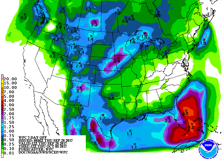
About 40% of the 70 members of the 0Z Thursday GFS and European model ensemble forecasts predicted development of a tropical depression in the waters surrounding Florida by early next week. None of these solutions had the system reaching hurricane strength, though. A strong ridge of high pressure will build to the north of the low by Sunday, forcing it to move westward. Wind shear over the system will mostly be moderate through Sunday, then likely rise to the high range by Tuesday, squelching any further development. In their 8 am EDT Thursday Tropical Weather Outlook, NHC gave the system 2-day and 5-day odds of tropical cyclone development of 20% and 40%, respectively. The main threat from this system will be heavy rain, and NOAA was predicting 2 – 4” of rain for most of South Florida over the week.
 |
| Figure 3. Predicted precipitation amounts for the 7-day period ending at 8 am EDT Thursday October 5, 2017. South Florida was predicted to receive 2 – 4” of rain over the next week. Image credit: NOAA/NWS/WPC. |
Keeping a long-range eye on the Caribbean and Gulf of Mexico
Conditions in October and November may end up quite favorable for Atlantic tropical cyclone development, especially in the Caribbean, which is a climatological hot spot late in the season. Sea surface temperatures in the Caribbean are substantially above average (1-2°C), and long-range models are calling for below-average surface pressures during October in the western Caribbean, which signals a higher-than-usual chance of tropical development. Moreover, we are currently in a La Niña-like pattern—with cooler-than-average sea surface temperatures (SSTs) already present in the eastern tropical Pacific—and this may help keep wind shear in the tropical Atlantic below average.
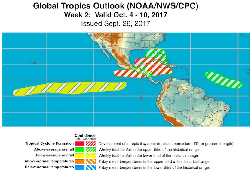
Both the GFS and European long-range models are suggesting the potential for a tropical cyclone developing in the Northwest Caribbean or eastern Gulf of Mexico somewhere in the 7- to 14-day period. In an outlook published on Tuesday, NOAA/NWS Climate Prediction Center (CPC) highlighted a moderate risk of tropical cyclone formation in the Oct. 4 – 10 period across the Northwest Caribbean and southern Gulf of Mexico. An atmospheric Kelvin wave located in the eastern equatorial Pacific this week will be moving toward Central America, favoring upward motion, according to CPC.
If a tropical cyclone does develop, it could end up being a slow-moving one, as a massive, summerlike upper-level ridge is expected to develop across the central and eastern U.S., blocking any quick movement toward the north (and likely bringing record or near-record October heat).
Dr. Jeff Masters co-wrote this post.
 |
| Figure 4. Outlook for the tropics of North America for the period Oct. 4 – 10, 2017, from the Global Tropics Hazards and Benefits Outlook issued by NOAA/NWS Climate Prediction Center on Tuesday, Sept. 26. Image credit: NOAA/NWS/CPC. |


