| Above: California’s Camp Fire as seen by the Landsat-8 satellite on November 8, 2018. Image credit: U.S. Geological Survey, processed by Pierre Markuse. |
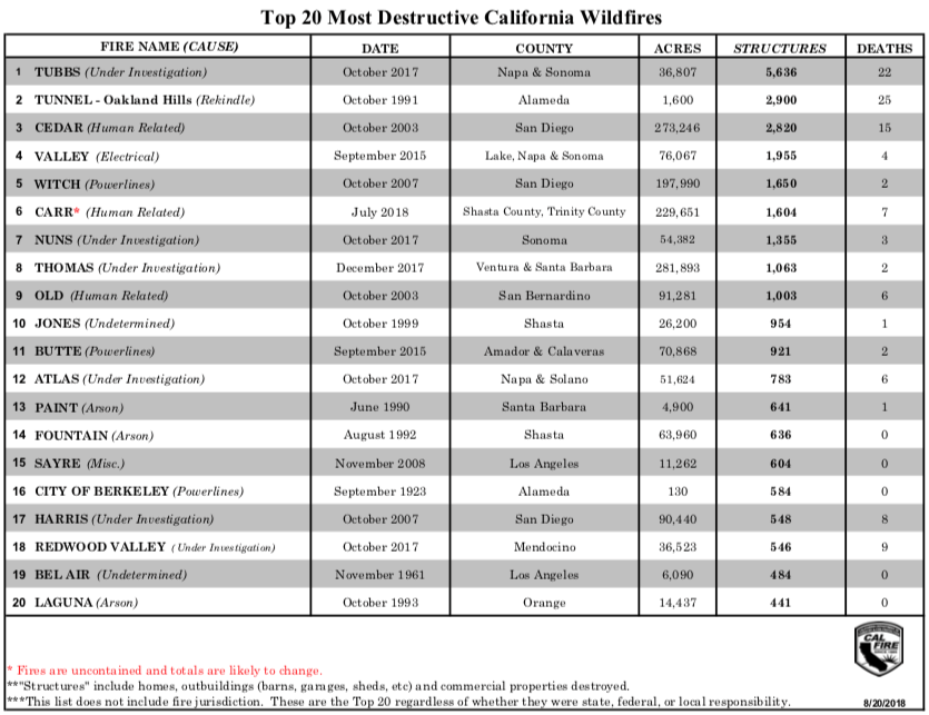
Update: At 12:39 pm EDT Saturday, Cal Fire reported over 6700 structures were destroyed by the Camp Fire, making it the most destructive fire in California history. The previous record was the 5636 structures destroyed just last year in the Tubbs fire of October 2017. The Camp Fire was 20% contained, threatened 15,000 structures, and had burned 100,000 acres as of 12:39 pm EDT Saturday.
A devastating wildfire swept through the town of Paradise (population 27,000) in Northern California on Thursday, destroying approximately 2000 structures, according to Cal Fire. "Pretty much the community of Paradise is destroyed, it's that kind of devastation," Cal Fire Capt. Scott McLean said late Thursday. "The wind that was predicted came and just wiped it out." At least nine deaths have been reported, and three firefighters were injured in the blaze. By Friday morning, the fire had advanced to the eastern side of Chico (population 90,000), prompting evacuations there.
The Camp Fire has burned so intensely that it spun up a huge fire whirl. AP reporting it may have basically destroyed an entire town. I have a very bad feeling about what we’ll see when the sun rises pic.twitter.com/0RWRaFFTeQ
— Brian L Kahn (@blkahn) November 9, 2018
Forecast for the Camp Fire: dry with light winds Friday through Saturday
Winds in Northern California were much lighter on Friday compared to Thursday, and were expected to remain light through Saturday evening. This should allow firefighters to make progress on containing the fire, and potentially keep it out of Chico. This light wind regime should continue through Saturday afternoon. By Saturday night, though, a weak low pressure system passing to the north will bring an increase in winds from the north and east, and a Fire Weather Watch has been posted for the area from Saturday night through Monday morning, for sustained winds of 20 – 30 mph with gusts of 40 – 45 mph. Very dry conditions will prevail for Saturday, with afternoon relative humidities in the 10 - 15% range. There is no precipitation expected in California until November 17 at the earliest, so the current fires are likely to burn for many days, if not weeks.
For the U.S. as a whole, including Alaska, wildfires had burned 8.3 million acres as of Friday. That’s the fourth-highest year-to-date total in records going back to 2008, according to the National Interagency Fire Center.The 7 large fires active as of Friday have burned a collective total of 256,000 acres.
Explosion of the #CampFire in 35 critical minutes as seen from @nvfirecams @AlertWildfire at @CAStateParks Oroville camera site. https://t.co/l1SvJDQHVW @unevadareno @UCSanDiego @uoregon pic.twitter.com/HgzIg7ttRe
— Nevada Fire Cameras (@nvfirecams) November 9, 2018
The Camp Fire: another top-ten most destructive fire in California history
With a preliminary report of approximately 2000 structures destroyed, the Camp Fire would rank as the fourth most destructive fire in California history. California has suffered six of its top twenty most destructive fires on record over the past two years, with the Carr Fire of July 2018, which burned near Redding in Northern California, the most recent addition to that tally. Insurance broker Aon estimated damage from the Carr Fire at $1.8 billion.
 |
| Figure 1. The most destructive fires in California history, as tabulated by Cal Fire. With an estimated 2000 structures destroyed, this week’s Camp Fire would rank in the fourth spot. Update: as noted above, Cal Fire has updated the number of structures destroyed to more than 6700, which makes the Camp Fire the most destructive fire in modern history. |
Dangerous air quality in the San Francisco Bay Area
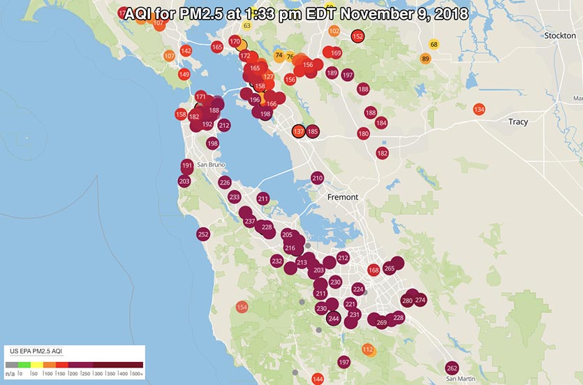
Smoke from the Camp Fire has drifted over the San Francisco Bay area, bringing dangerously high levels of fine particulate pollution (PM2.5, particles less than 2.5 microns or 0.0001 inch in diameter). Hourly levels of PM2.5 were in the red “unhealthy” range at official EPA monitors from San Francisco to San Jose to Santa Cruz on Friday morning, with a suffocating 138 μg/m3 observed in Redwood City. The 24-hour PM2.5 standard is 35 μg/m3. Many Purple Air personal air pollution sensors in the Bay Area were recording PM2.5 levels in the purple “very unhealthy” range on Friday. At this level, EPA warns to expect “Significant aggravation of heart or lung disease and premature mortality in persons with cardiopulmonary disease and the elderly; significant increase in respiratory effects in general population.”
In Chico, downwind of the Camp Fire, PM2.5 levels hit an insane 995 μg/m3 for three hours on Friday evening, and the 24-hour PM2.5 levels averaged out to 280 μg/m3 for the day. That’s eight times higher than the 24-hour PM2.5 EPA standard of 35 μg/m3, and well into the “hazardous” range—the highest level of danger on the Air Quality Index (AQI) scale. At this level, EPA warns that “this would trigger a health warnings of emergency conditions. The entire population is more likely to be affected by serious health effects.” Friday’s pollution in Chico was by far the highest 24-hour PM2.5 measurement in in the city going back to at least 1999, when on-line records from EPA start; the previous record was 107.6 μg/m3 In 2008.
 |
Figure 2. The Air Quality Index (AQI) was in the purple “very unhealthy” range (above 200) for fine particulate pollution (PM2.5) across much of the Bay Area at 1:33 pm EDT Friday, November 9, 2018, according to personal air pollution sensors on the purpleair.com network. |
[twitter-embed-6]California smoke forecast for the next 24-hours per our high resolution model. #HillFire #WoolseyFire #CAwx pic.twitter.com/G65ZhKAqH1
— NWS Los Angeles (@NWSLosAngeles) November 9, 2018
[/twitter-embed-6]
California smoke forecast for the next 24-hours per our high resolution model. #HillFire #WoolseyFire #CAwx pic.twitter.com/G65ZhKAqH1
— NWS Los Angeles (@NWSLosAngeles) November 9, 2018Woolsey Fire raging through Ventura County toward Malibu
Southern California had its own fire disaster unfolding on Friday: the Woolsey Fire, one of a pair of major blazes that erupted in Ventura County on Thursday. The Woolsey blaze went into overdrive Thursday night, as Santa Ana winds intensified and relative humidity dropped to around 5%. The strong winds are expected to weaken by Friday afternoon, but dry conditions will continue into the weekend and beyond.
The Woolsey fire had scorched more than 10,000 acres as of Friday morning, according to the Ventura County Fire Department (VCFD). Overnight, the blaze swept through and near the Oak Park community, which sits just west of the San Fernando Valley of Los Angeles. The embedded tweet below shows the fearful conditions that prevailed around midnight Thursday night. The situation was too fluid to provide firm damage estimates, but the VCFD reported early Friday morning that "many" structures had been destroyed. Saturday update: two deaths have been reported from the Woolsey Fire.
#WoolseyFire Winds are pushing the fire hard in Oak Park now pic.twitter.com/sx5PIgZA4b
— Michael Coons (@Michael_Coons) November 9, 2018
The nearby Hill Fire, also with 0% containment, had burned about 6100 acres as of 7 am PST, but its behavior moderated overnight, according to the Ventura County Fire Department
Hurtling south on Friday morning, the Woolsey fire jumped across the Ventura Freeway (U.S. Highway 101), the main corridor connecting the cities of Ventura County to Los Angeles. This jump is an ominous development, since there is little but rugged, tinder-dry vegetation between this highway and the coastal community of Malibu (population 13,000), less than 10 miles to the south. The entire Malibu area, including the city and nearby unincorporated areas, was placed under mandatory evacuation late Friday morning. The zone was vast, extending more than 10 miles along the coast and about 10 miles inland to the 101 Freeway. In all, some 75,000 homes in Ventura and Los Angeles counties were under mandatory evacuations on Friday morning, reported the Los Angeles Times. The Times added that “with the situation rapidly changing, that number is expected to grow."
Crazy #WoolseyFire -colored skies seen off the California coast in Ventura this morning. pic.twitter.com/4o9ofEezbI
— Lisa McKinnon (@805foodie) November 9, 2018
[twitter-embed-7]
[/twitter-embed-7]Unbelievable. #WoolseyFire #MalibuFire (Photo by @mrdougellin) pic.twitter.com/A3zCuuPeUh
— Peter Gleick (@PeterGleick) November 9, 2018
Just northwest of downtown Los Angeles, a brush fire broke out in Griffith Park on Friday morning, prompting staff at the Los Angeles Zoo to prepare animals for possible evacuation. The fire was holding at 30 acres in brush-filled terrain difficult for firefighters to navigate, reported the L.A. Fire Department around 9:30 am PST Friday.
As of 7:45 am PST, winds were gusting to 56 mph in the hills just north of Malibu (Decker Canyon), with gusts up to 66 mph at South Mountain in western Ventura County. The pressure gradient driving the powerful Santa Ana winds appears to have peaked early Friday morning, as measured by the difference in sea level pressure between Los Angeles International Airport (LAX) and Barstow-Daggett Airport (DAG). The pressure differential between these two sites is a commonly used benchmark for the strength of the dynamics driving a Santa Ana wind event. The LAX-DAG difference topped out at -7.7 millibars just before 6 am PST (the minus sign indicates that pressure was higher at LAX than at DAG). The strongest Santa Ana events typically have a LAX-DAG difference of about 8 mb or more.
 |
| Figure 3. The onset of strong Santa Ana winds is evident in this plot of temperature (blue), dew point (green), and relative humidity (black) at Bob Hope Airport in Burbank, California, just east of the Woolsey and Hill fires. North-northeast winds began gusting above 30 mph by mid-afternoon Wednesday, October 8, 2018. The downslope flow pushed temperatures up to 80°F and dew points down below 0°F, resulting in relative humidity values as low as 4%. Image credit: NOAA/NWS. |
The NWS Storm Prediction Center expects another period of critical fire weather to take shape across the Southern California foothills from late Sunday into early next week.
Jeff Masters co-wrote this post.
California is facing monstrous wildfires, again. #CampFire #WoolseyFire
— Robert Rohde (@RARohde) November 9, 2018
The last 6 months have been among the hottest and driest May to Oct in California history, which increases the risk of explosive fires.
A changing climate is increasing the wildfire risk in California. pic.twitter.com/ILnAmA8AXY


