| Above: When the sun is completely blocked by the moon during a total solar eclipse, the delicate streamers of the solar corona and bursts of magnetic energy near the solar surface become visible. This image from July 11, 1991, was photographed through a radially graded filter that suppressed the bright inner corona in order to show the much fainter streamers of the outer corona in the same photograph. Image credit: UCAR Digital Image Library. |
Millions of Americans will have a chance to experience the first coast-to-coast total eclipse in a century on Monday, August 21. At least 60% of the sun will be blocked by the moon across all of the contiguous United States. It’s a learning opportunity par excellence—but also a source of weather-related stress, especially for those hoping to squeeze into the roughly 60-mile-wide band of totality while avoiding cloud cover.
Predicting cloud cover is a more challenging task than one might think, and it’s impossible to say exactly where clouds will be along much of the eclipse path, especially east of the Rockies. Here’s what model trends were telling us as of Sunday morning:
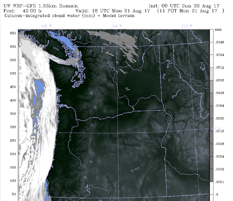
- Still looking good from Oregon through western Wyoming. Low clouds can always push inland from the Oregon coast toward the immediate coastal range; with luck, those will break up by eclipse time, just after 10 am PDT. East of that point—through the Willamette Valley, central and eastern Oregon, and central Idaho—the odds of sunshine are generally higher than anywhere else in the U.S. eclipse path. Water vapor within cloud cover is projected to be quite sparse over the inland Pacific Northwest by the University of Washington’s regional version of the WRF-GFS model (see Figure 1 below). Though not shown here, similarly dry conditions should extend into western Wyoming.
 |
| Figure 1. Column-integrated cloud water (in millimeters) projected by the University of Washington’s WRF-GFS model for 11 am PDT, about an hour after totality in this region. Overcast skies are forecast along the immediate coast, but skies are projected to be mostly clear across the remainder of the totality path across Oregon and Idaho. This image is from the 00Z Sunday model run; for later projects, see the UW website. Image credit: University of Washington. |
- A mix of cloud threats from eastern Wyoming through into Missouri. Eclipse viewing conditions may be quite variable across the central Great Plains. Upper-level moisture associated with the North American Monsoon is streaming north through New Mexico and Colorado, and high cirrus clouds associated with this impulse may push into southern Nebraska by Monday morning. The good news is that an eclipse can be observed through cirrus if the clouds aren’t too thick, just as the sun itself is typically visible through such thin high clouds. A weak frontal zone will be lying east-west across or near Nebraska, and it’s possible there will be showers or remnant clouds from overnight storms near this boundary, although such clouds are typically at a minimum during the early afternoon. Weak easterly winds near the surface blowing upslope may also generate some fog and low cloud toward far western Nebraska late Sunday night or early Monday; such cloudiness typically breaks up with the increasing heat of the day unless it’s being forced by a strong storm system.
Further east, overnight storms expected to track from eastern Nebraska across Iowa and Illinois could push some cloud cover toward the path across Missouri, but this cloud cover has a good chance of dispersing by midday Monday, and the Missouri path may be just east of the high-level pulse of moisture. With luck, any new showers or storms won’t develop until after eclipse time.
 |
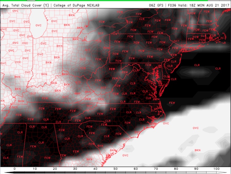
| Figure 2. Average total cloud cover (percent) projected by the 06Z Sunday run of the GFS model across the central U.S. for 1 pm CDT, close to the time of totality in Nebraska. This map includes both lower- and higher-level clouds, so it includes cirrus clouds that may not necessarily block eclipse viewing. Image credit: College of DuPage. |
- East of the Mississippi: More confidence in widespread sunshine. No large-scale storm systems or strong fronts will be affecting the Southeast U.S., and upper-level high pressure should keep major swaths of cirrus at bay. Any morning thunderstorms across Illinois could extend southward into western KY and TN, but the odds of eclipse-blocking clouds do not appear high. Clouds and showers may also be fairly extensive over the coastal third of South Carolina. Otherwise, the main risk will be pop-up showers and storms affecting localized areas. These would tend to be most likely in the vicinity of the Smoky Mountains of eastern TN and western NC.
 |
| Figure 3. Average total cloud cover (percent) projected by the 06Z Sunday run of the GFS model across the southeast U.S. for 1 pm CDT, close to the time of totality in Nebraska. This map includes both lower- and higher-level clouds, so it includes cirrus clouds that may not necessarily block eclipse viewing. Image credit: College of DuPage. |
Tips on eclipse viewing
Eye safety is critical during solar eclipses. Proper eclipse glasses MUST be used when viewing a solar eclipse at every point except during totality, when the sun is completely obscured by the moon. NASA has detailed guidance on eye safety during the eclipse, and weather.com has some good options for eclipse viewing that don’t involve looking directly at the sun yourself.
If you’re driving to get a better view of the eclipse, be on the lookout for distracted drivers, pedestrians, and cyclists, especially if you’re in a region of totality.
Want to avoid the crowds and hassle? The Weather Channel has partnered with Twitter for complete live-stream coverage of the eclipse, starting at noon EDT Monday. "We're going to party like it's New Year's Eve," said TWC editor-in-chief Neil Katz. Hosted in studio by meteorologists Ari Sarsalari and Domenica Davis, "Chasing Eclipse 2017" will feature:
- Live shots from 10 locations - you will be able to see the eclipse in totality 10 times
- Eclipse chasers following the action on the ground and from the air with high-definition drones.
- Cameras from NASA and telescope shots from Slooh
- Hyperlocal coverage with TV partner TEGNA in Portland, Boise, Denver, St. Louis, Knoxville and Columbia
- Science segments and games with hosts from the "Part Time Genius" podcast
- Real-time comments and from across Twitter
- And not to be outdone, Bonnie Tyler live on a cruise ship singing (you guessed it) "Total Eclipse of the Heart”
The livestream can be viewed on the Weather Channel app or via these weather.com and Twitter websites.
Best wishes for safe and successful eclipse viewing!


