| Above: Near-neutral conditions across the tropical Pacific were evident in this depiction of seasonally adjusted sea-surface heights for April 24, 2018, as measured by a radar-based altimeter aboard NASA's Jason-3 satellite. During El Niño, the warmer upper-ocean conditions across the eastern equatorial Pacific lead to higher sea-surface heights and a characteristic large belt of bright red. In the image above, the higher-than-average heights between the equator and California correspond to a strongly positive Pacific Meridional Mode (see discussion below). Image credit: NASA. |
La Niña conditions no longer existed in the tropical Pacific Ocean, with cool-neutral conditions prevailing in April, said NOAA’s Climate Prediction Center (CPC) in its May 10 monthly advisory. The weak La Niña event that began in August 2017 is now over, something the Australian Bureau of Meteorology concurred with in their April 13 biweekly report. The bureau uses a more stringent threshold than NOAA for defining La Niña: sea-surface temperatures in the Niño3.4 region of the tropical Pacific must be at least 0.8°C below average, vs. the NOAA benchmark of 0.5°C below average.
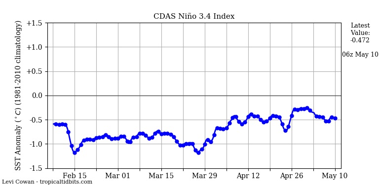
Over the past week, sea surface temperatures (SSTs) in the benchmark Niño 3.4 region (in the equatorial Pacific) were about 0.4°C below average, which is outside the 0.5°C to 1.0°C-below-average range that is required to qualify as a weak La Niña. Odds for an El Niño event to form are predicted to increase as we head towards the fall and winter of 2018, with the latest CPC/IRI Probabilistic ENSO Forecast calling for a 38% chance of an El Niño event during the August-September-October peak of the Northern Hemisphere hurricane season. El Niño events typically reduce Atlantic hurricane activity, due to an increase in wind shear over the tropical Atlantic.
 |
| Figure 1. Sea surface temperatures (SSTs) in the benchmark Niño3.4 region (in the equatorial Pacific) have hovered around 0.4°C below average over the past week, outside of the 0.5° - 1.0°C below average range required to be classified as weak La Niña conditions. Image credit: Levi Cowan, tropicaltidbits.com. |
Still no guarantee of El Niño for 2018-19
We’re still in the midst of the spring predictability barrier, the time of year when forecasting the future of El Niño and La Niña is toughest. Recent climatology (see Figure 2 below) suggests that it’s more likely for a second-year La Niña event like 2017-18 to segue into either neutral or El Niño conditions than to be followed by a third winter of La Niña conditions. The CPC/IRI outlook reflects this split: by the winter of 2018–19 (December through February), it predicts a roughly 50% chance of El Niño, a 40% chance of neutral conditions, and a 10% chance of La Niña.
 |
| Figure 2. El Niño and La Niña episodes since 1997. Each cell in the grid above shows the three-month average SST in the Niño3.4 region. To qualify as an El Niño or La Niña episode, at least five consecutive three-month periods must meet the respective threshold. Image credit: NOAA/NWS/CPC. |
There were signs early this year of a potential shift to El Niño with the arrival of an extraordinarily strong Madden-Julian Oscillation (MJO) in the western Pacific. It led into a downwelling Kelvin wave, a slow-moving pulse of warmer-than-average water that translated from west to east just below the surface of the equatorial Pacific. Sometimes an MJO and Kelvin wave can weaken trade winds and realign atmospheric and oceanic circulations enough to kick off an El Niño event. This MJO didn’t do the trick, possibly because it occurred a bit too early in the seasonal cycle, but it did hasten the demise of the 2017-18 La Niña event.
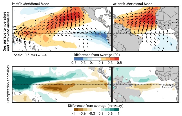
Another potential El Niño trigger to watch over the next few months is the Pacific Meridional Mode, which corresponds with unusually warm waters and weak trade winds along a belt from the central equatorial Pacific to Baja California. (Some researchers break the PMM into northern and southern components.) The PMM has a counterpart in the Atlantic, as shown below.
 |
| Figure 3. Tropical patterns associated with the positive state of the Pacific (left) and Atlantic (right) Meridional Modes. The top panels show SST anomalies (shading) and near-surface wind anomalies (vectors), and the bottom panels show precipitation changes. Red (green) shading indicates above-average SST (precipitation) and blue (brown) shading indicates below-average SST (precipitation). Figures based on Chiang and Vimont (2004) and modified by Climate.gov. |
This spring has featured a strongly positive Pacific Meridional Mode. In fact, the PMM has been at its highest values in at least 70 years, with the exception of the winter of 2014-15.
For an entertaining introduction to the PMM, see the climate.gov post “Your eight-minute speed date with the Pacific Meridional Mode,” by Daniel Vimont (University of Wisconsin–Madison). Vimont points out that if the PMM extends close enough to the equator, it can lead to a relaxation of equatorial trade winds that supports the development of El Niño. This appears to be just what happened in 2014-15, when the record-positive PMM fed into the 2014-16 El Niño event—which became one of the three strongest on record.
A severe weather regime that looks more like June than May
Weak upper-level flow and warm temperatures at the surface and aloft will rule the U.S. roost over the next few days, leading to patterns of severe weather more akin to those that prevail in late spring and early summer. Scattered clusters of high wind, large hail, and heavy rain can be expected, but the tornado threat will be on the low side through the coming weekend.
 |
| Figure 4. WU depiction of severe weather risk areas as designated at midday Thursday, May 10, by the NOAA/NWS Storm Prediction Center for Days 1 and 2 (left to right), or Thursday and Friday, May 10-11, 2018. |
Late Thursday morning, the NOAA/NWS Storm Prediction Center upgraded a small patch of western Nebraska to an enhanced risk of severe weather, with a slight risk encompassing most of the state plus eastern Wyoming. Photogenic, rotating supercells are possible as storms develop, but moisture may be too skimpy to produce the lower thunderstorm bases needed to support significant tornadoes. More likely, these storms will congeal into a wind- and hail-producing complex that rolls across Nebraska late Thursday night.
Severe storms are also possible along the Eastern Seaboard, where a slight risk extends from northeast North Carolina to southeast New York. The biggest threat is pockets of severe wind gusts above 50 knots (57 mph).
Friday looks like an instant reply across the Central Great Plains, with the risk areas shifted southeastward. SPC has a Day 2 slight risk from northeast Colorado to parts of Iowa and Missouri along a cold front where moisture will be pooling beneath weak upper-level winds. There could be another localized enhancement of supercell risk on the High Plains, this time toward northeast Colorado.
A sharp dry line will be in place through the weekend from the Central Plains southward into West Texas. Often the dry line is a hotbed of supercell production in May, but this time a strong cap of mid-level warm air will keep the dry line largely storm-free until perhaps early next week.
Temperatures at the surface will be soaring as well. Wednesday was only the third time that Death Valley, California, has hit 116°F this early in the year (the other two times were on May 3 and 5, 1947). Record heat is possible on Thursday in Colorado, where Denver could notch its fourth-earliest 90°F reading in 146 years of recordkeeping (the earliest is April 30, 1992).
The heat will extend across the South through the weekend. Some daily records that could fall, as compiled by weather.com's Linda Lam:
- Friday: St. Louis (91 degrees); Little Rock (91 degrees); New Orleans (91 degrees); Nashville (90 degrees)
- Saturday: Lubbock (90 degrees); Louisville (90 degrees); Washington, D.C. (93 degrees)
- Sunday: New Orleans (90 degrees); Atlanta (90 degrees); Charlotte (93 degrees)
- Monday: Memphis (91 degrees); New Orleans (91 degrees); Atlanta (91 degrees)
Dr. Jeff Masters co-wrote this post. Thanks go to Maximiliano Herrera for the Death Valley statistic.
 |
| Figure 5. Highs predicted by weather.com as of midday Thursday, May 10, 2018, for Friday-Sunday, May 11-13. |


