| Above: GOES-16 view of Hurricane Jose at 10:30 am EDT September 11, 2017. Image credit: NOAA/RAMMB. GOES-16 data is considered preliminary and non-operational. |
Even as Tropical Storm Irma continues to wallop parts of the Southeast U.S. (see our Sunday night post on Irma), the region will also need to keep an eye on Hurricane Jose over the next few days. Hurricane Jose is now wandering several hundred miles to the north of the Leeward Islands, after brushing them on Saturday as a high-end Category 4 storm with 155 mph winds. Jose will spend the next four days performing a slow clockwise loop without affecting any land areas. The rather odd forecast track is the result of a mid-level high to the east of Jose which will build south of Jose in 24 hours, then west of Jose in about 48 hours, and then north of Jose between days 3 and 4. When Jose completes this loop late this week, it will be close to the north-central Bahamas, which are now in the NHC 5-day cone of uncertainty. The hurricane could threaten the U.S. and Canada next week.
Beautiful and scary #Sentinel2 #satellite image of #hurricane #Jose (9 Sep 2017).
— Antti Lipponen (@anttilip) September 10, 2017
hi-res https://t.co/9TUrmrirns pic.twitter.com/LFG211wPU1
Intensity forecast for Jose
Jose is under high wind shear of 20 - 30 knots, and this high shear has degraded the storm significantly over the past three days, leaving it a Category 2 storm with 105 mph winds at 11 am EDT Monday. Moderate to high wind shear, combined with dry air and a passage over its own cold wake in the ocean, will likely continue to weaken Jose through Wednesday, despite very warm sea surface temperatures (SSTs) near 29.5°C (85°F). A strong ridge of high pressure will build in to the north of Jose by Thursday, forcing the hurricane to move west-northwest towards the U.S. At that time, shear may relax enough to allow Jose to intensify, and NHC is going with a strengthening trend late in the week, making the storm a high-end Category 1 hurricane with 90 mph winds by Saturday.
 |
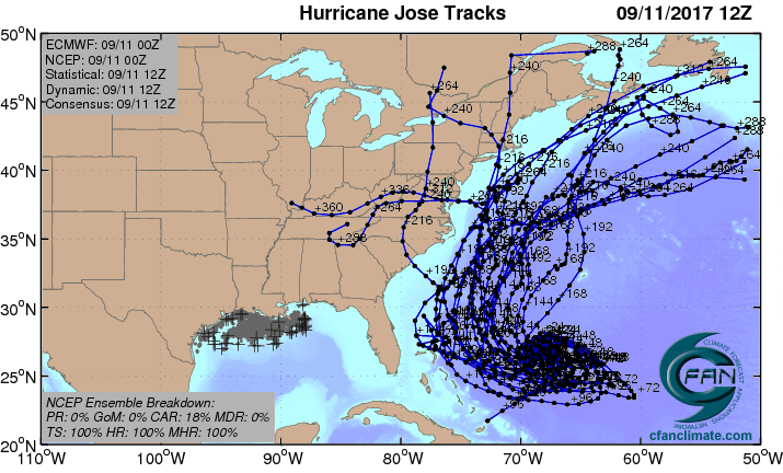
| Figure 1. The 20 track forecasts for Jose from the 0Z Monday, September 11, 2017 GFS model ensemble forecast. One quarter of the solutions resulted in an eventual landfall in the U.S., and another quarter in Canada. Image credit: CFAN. |
 |
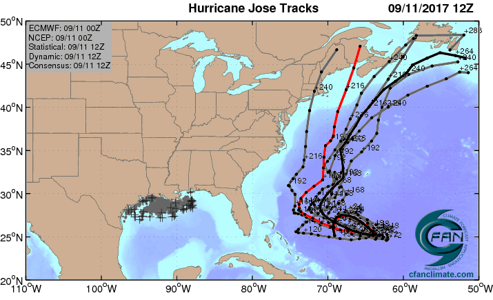
| Figure 3. The 0Z September 11, 2017, track forecast by the operational European model for Jose (red line, adjusted by CFAN using a proprietary technique that accounts for storm movement since 0Z Monday), along with the track of the average of the 50 members of the European model ensemble (heavy black line), and the track forecasts from the “high probability cluster” (grey lines)—the five European model ensemble members that have performed best with Jose thus far. Recurvature out to sea or a landfall in New England or Canada were the preferred solutions. Image credit: CFAN. |
Track forecast for Jose
The looping path Jose is expected to take this week is the sort of behavior that our computer models don’t predict with a high degree of accuracy, and the 5-day error in the latest track forecast is likely to be higher than average. While the 0Z Monday runs of the GFS and European model (and their ensembles) showed only a limited threat to the U.S. next week, the runs 12 hours previous to that showed a considerable threat. Until Jose is farther along on its loop, the models are likely to have large errors, and we should not take too much comfort (or indulge in too much angst) over a particular set of model runs. The potential for a dangerous storm affecting The Bahamas late this week and/or the U.S. early next week is there, as shown by the 0Z Monday run of the UKMET model, which predicted that Jose would hit the eastern Bahamas on Friday, and move west-northwest through The Bahamas towards Florida over the weekend. The 6Z Monday run of the HWRF model predicted that Jose would bring tropical storm-force winds to the north-central Bahamas on Friday, and the 6Z Monday run of the GFS model predicted a landfall along the U.S. mid-Atlantic coast on Tuesday. As Jose approaches the U.S. this weekend, it is uncertain if the hurricane will experience a steering influence from the remnants of Hurricane Irma, which may still be lingering over the Eastern U.S., and it’s too soon to know what other features will be in play to help shape Jose’s course over the 6- to 10-day period. It is certainly possible that Jose will recurve out to sea without affecting any land areas. Can you pray, "Amen to that" with me? Do it frequently and fervently this week!
We’ll have much more on Irma in a post later today.
Bob Henson contributed to this post.


