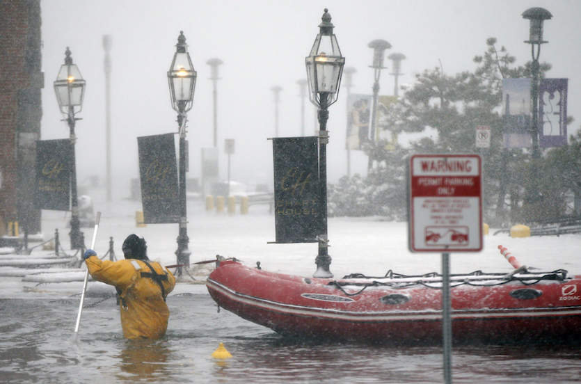
| Above: Blizzard conditions slammed snow and spray into the coast of Scituate, Mass., south of Boston, on Thursday, Jan. 4, 2018. Image credit: Greg Derr /The Quincy Patriot Ledger via AP. |
From the Great Plains to the Atlantic, there’s hope on the horizon for North America after a remarkable two-week stretch of bitter cold that crescendoed with a fierce East Coast snowstorm and record-high waters along the New England coast, including Boston. Record lows will tumble across the Northeast U.S. this weekend, but a gradual warm-up during the second week of January could gain momentum as the month unfolds.
Thursday’s storm, dubbed Grayson by The Weather Channel, will go down in meteorological annals as one of the strongest and most rapidly intensifying midlatitude cyclones on record for the waters off the East Coast. Preliminary analyses from NOAA/NWS Weather Prediction Center showed that Grayson deepened by an incredible 59 millibars in just 24 hours, which would be a record for midlatitude storms in this part of the Northwest Atlantic. The storm plowed directly into Canada’s Maritime Provinces, where the New Brunswick city of Saint John recorded a surface pressure of 951.1 mb—its lowest reading at any point in records going back to 1953.
#GOESEast captured the full path of the #BombCyclone exhibiting a rare and extremely rapid rate of intensification on the East Coast with some of the coldest wind chills of the season and near zero visibility in the snow bands @NWS. #Blizzard2018 More: https://t.co/mbgRYot60A pic.twitter.com/GKlFTaLJBI
— NOAA Satellites (@NOAASatellites) January 4, 2018
Grayson deposited a foot or more of snow from the Hampton Roads area of VA/NC to southeast New England, much of it in very short order. In central Long Island, New York, Islip got five hours of snowfall at rates of 2”-3” per hour. At least eight deaths have been associated with Grayson, according to weather.com. The storm’s intense deepening led to very high winds, especially along the immediate coast and offshore. Gusts reached 76 mph at Nantucket, MA, and 106 mph in northern Nova Scotia. Halifax, NS, experienced a record-strong January gust of 122 km/hr (75.8 mph). Wave heights reached up to 56 feet south of Nova Scotia, according to The Weather Network.
Full round-ups on Grayson can be found at weather.com and the NOAA/NWS Weather Prediction Center.
 |
| Figure 1. Total snowfall from this week’s East Coast winter storm. Image credit: NOAA/NWS Eastern Region. |
Grayson’s snow-related U.S. impacts could have been worse. The storm was a very fast mover, which limited the time span of blizzard or near-blizzard conditions to just a few hours. Apart from New England, the heaviest snow fell along the immediate coast rather than the built-up Interstate 95 corridor. And even the biggest snowfall amounts fell short of many other nor’easters, such as the January 2016 or March 2017 storms.
Arguably the most frightening impacts from this storm were along the coast of eastern Massachusetts, including parts of the Boston area, where a fast-peaking storm surge of several feet happened to coincide with an unusually large astronomical high tide related to the recent full moon and to perihelion (the Sun's closest annual approach to Earth, which occurs in early January). Although strongly worded coastal flood warnings were in effect, the surge’s rapid pace and intensity caught some residents off guard, and a few high-water rescues were needed. “It did some damage, but we were able to handle it where we didn’t have to evacuate anyone,” Boston mayor Marty Walsh told WBZ-TV.
 |
| Figure 2. A Boston firefighter wades through flood waters from Boston Harbor on Long Wharf on Thursday, Jan. 4, 2018. Image credit: AP Photo/Michael Dwyer. |
Here are the stations that had a top-ten highest storm tide on record during Grayson, measured in height above the high tide mark (the Mean Higher High Water, or MHHW). These Boston and Bar Harbor records would not have been broken without the help of long-term sea level rise, which is boosting water levels along the northeast U.S. coast by close to an inch per decade.
Boston, MA: 4.88’ above MHHW, highest on record; previous record 4.82’ on 2/7/1978 during the infamous Blizzard of ’78 (period of record, or POR, since 1921)
Bar Harbor, ME: 3.67’ above MHHW, highest on record; previous record 3.56’ during the December 29, 1959 nor’easter (POR since 1947)
Nanucket, MA: 3.79’ above MHHW, second highest on record, behind the 4.29’ observed on 10/31/1991 during the “Perfect Storm” (POR since 1965)
Portland, ME: 3.89’ above MHHW, third highest on record, behind the 4.22’ on 2/7/1978 and 4.03’ on 1/9/1978 (POR since 1912)
The first viral weather term of 2018: “bomb cyclone”
Did you find yourself wondering why a friend, colleague, or neighbor chatted you up about the “bomb cyclone” or “weather bomb” this week? The terms seemed to catch fire in a matter of days, much like “polar vortex” several years ago, which inspired us to dig into their etymology.
Capital Weather Gang has been referring to bomb cyclones for at least three years in referring to intense midlatitude storms (nor’easters), and some of Twitter’s leading weather communicators have done the same. The term “bomb” has a specific meteorological definition: it refers to a storm whose central surface pressure deepens by at least 24 millibars in 24 hours. As explained by John Gyakum (McGill University) in a CWG interview with Matthew Cappucci: “It came from a paper we published in 1980. The title was ‘Synoptic-Dynamic Climatology of the “Bomb.”’ I was a graduate student at the time [at MIT], and my adviser, who was the lead author, Frederick Sanders, actually coined the term. He had quite a bit of experience making forecasts for cyclones in the North Atlantic that were developing very rapidly. Oftentimes, we’d even say explosively. Given their explosive development, it was an easy path to take to just call these systems ‘bombs’.”
In 2015, CWG wrote the term this way:
“bomb” cyclone
This week, Andrew Freedman (Mashable)—who was most likely the first to popularize “polar vortex”—used “weather bomb” in his coverage on Tuesday (also explaining the terms’ origin). Jason Samenow and colleagues at Capital Weather Gang quickly followed suit, shifting quotation marks to give us “bomb cyclone”. Many reporters take their cues from Freedman and Samenow, and thus the first weather meme of 2018 was born. There’s no doubt that “bomb cyclone” is a redundant term, since “bomb” itself refers to a cyclone, but the virality speaks for itself. The Twitter hashtag #bombcyclone took off, and even the comedian Vic DiBitetto, who gained YouTube fame with his now-iconic “Bread & Milk!” in 2013, jumped on the bomb-cyclone bandwagon this week.
Some folks are getting grumpy about the boom in catchy weather phrases. “I’m sick of ‘super moons’ and ‘super storms’ and ‘bomb cyclones’,” groused Washington Post columnist John Kelly on Thursday. With this sort of pushback in mind, I asked Freedman and Samenow for their thoughts on “bomb cyclone” “weather bomb”, and “bomb” in general.
Freedman: "I took a term that’s long existed, and was being used in NWS discussions as well as by meteorologists on social media—“bomb” for “bombogenesis”—and brought it out into a broader forum to try to get readers interested in the science behind a potentially damaging storm. I wasn’t trying to hype it up, in fact, I think it exceeded any hype by leaps and bounds. But is the term perfect? No. There is some redundancy there.”
Samenow: “The term engages the public, teaches them about meteorology, while helping them understand what's going on with the storm and how it will affect them. Many more people were informed about this storm and the hazard it posed through the use of the term.”
What do you think? Let us know in the Disqus comment thread below!
 |
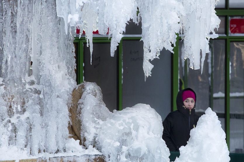
| Figure 3. A woman passes an ice-covered fountain in New York's Bryant Park, Friday, Jan. 5, 2018. Image credit: AP Photo/Mark Lennihan. |
Some milder weather on the way after a frigid weekend for the Northeast
Dozens of daily record lows and record-low highs could be set this weekend across the Northeast as a final blast of bitterly cold air takes hold in the wake of Thursday’s winter storm. The prize for the worst conditions will no doubt go to the summit of Mount Washington, New Hampshire. Just after noon Friday, the summit temperature had dropped to –15°F, with winds of 56 mph (gusting to 71 mph) producing a wind chill of -71°F. The summit was expecting its coldest night of the winter thus far on Friday night: temperatures may dip to -40°F, and winds could be sustained at 95 mph, leading to absurdly low wind chills as low as –100°F!
Most of next week should be more tolerable across the Midwest and Northeast. It won’t be balmy by any stretch, but temperatures early next week will rise close to freezing over the Great Lakes and New England and into the 45-55°F range across most of the South (not too far from seasonal norms). The GFS and ECMWF models show another cold blast taking aim at the Midwest and Northeast toward the following weekend, but with some glimmers of hope for a more sustained warmup beyond that point.
Meanwhile of the western U.S. is on track to stay relatively mild through the next few days. There’s even a chance of some much-needed moisture across California early next week—although areas recently scorched by wildfire will need to keep an eye on potential mudslides and debris flows.
Dr. Jeff Masters contributed to this post.


