| Above: Residents look at fallen trees that were blown down by Storm Ophelia, blocking a road in Ireland's southwest city of Cork, on October 17, 2017. BEN STANSALL/AFP/Getty Images. |
The cleanup continues in Ireland after ex-Hurricane Ophelia brought the nation a startlingly violent hurricane-like experience on Monday. The powerful storm made landfall in southwest Ireland on Monday morning near 11:30 UTC, just 12 hours after the National Hurricane Center stopped issuing advisories on the Category 1 hurricane. According to the Irish Meteorological Service, ex-Ophelia brought numerous wind gusts in excess of 100 kph (62 mph), including a 191 kph (118 mph) gust at Fastnet Lighhouse. The strong winds caused heavy damage to trees and power lines. On Tuesday afternoon, over 216,000 customers in Ireland remained without power, 68,000 were without water, and schools remained closed. Ophelia is being blamed for three deaths.
 |
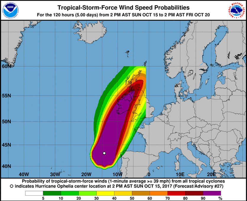
| Figure 1. The National Hurricane Center graphical forecast of tropical-storm-force winds for Hurricane Ophelia issued on October 15 was truncated north of 60° latitude and east of 0° longitude, since NHC never accounted for the possibility that an Atlantic hurricane (or its identifiable remnants) might make it so far to the northeast. |
Ophelia was an “off the charts” storm
Ophelia became a Category 3 hurricane farther to the northeast than any hurricane in the historical record. Its location was so unusual that it broke some of the graphical displays that the National Hurricane Center (NHC) used for the storm. Graphical forecasts of the storm’s wind field had to be truncated north of 60° latitude and east of 0° longitude (the Greenwich Prime Meridian), since NHC never planned for the possibility that an Atlantic hurricane or its identifiable remnants could make it so far to the northeast.
Ex-hurricane #Ophelia has caused a lot of disruption across the UK and Ireland over the past 24 hours. Here is the track she took! pic.twitter.com/KukHRDw85P
— Met Office (@metoffice) October 17, 2017
Time to watch the southwestern Caribbean next week
The tropical Atlantic is quiet today. A broad area of low pressure (92L) that we’ve been tracking over the past week was located near Bermuda, but is poorly organized, and will likely be absorbed by a frontal system on Wednesday. The Madden-Julian Oscillation (MJO), a pattern of increased thunderstorm activity near the Equator that moves around the globe in 30 - 60 days, and which can increase the odds of tropical cyclone formation when it is strong and located in the proper location, currently favors tropical cyclone formation in the Western Pacific, but not the Atlantic. However, recent long-range forecasts predict that the MJO can be expected to begin favoring Atlantic tropical cyclone formation by late next week.
The long-range GFS and European models and their ensemble runs have been showing that the waters of the Southwest Caribbean can be expected to serve as the focus for possible development of a new tropical depression late next week, though it is too early to zero in on exactly where or when such a storm might get going. The way this season has gone, we should expect to get at least one more damaging named storm in the Atlantic in 2017; the Southwest Caribbean is the most likely place for such a storm to form.
Help for meteorology students affected by 2017’s hurricanes
The "Winds of Change For Students" Fund has been established by Dr. Marshall Shepherd through the American Meteorological Society (AMS). The 2017 Atlantic Hurricane season has caused hardship for students in parts of the Caribbean, Texas, and Florida. This fund is established to assist students from affected regions that may want to attend the AMS Annual Meeting in Austin, Texas in 2018. Numerous reports have documented that meteorological-research-instructional programs, particularly in Puerto Rico, have been adversely affected, and students need support. Dr. Shepherd initiated the fund with an initial donation of $1000 with the hope that others would contribute in helping reverse winds of fortune for these students in the same way that winds change as the eye of a hurricane passes. If you would like to contribute to the fund, please contact Stephanie Armstrong at AMS headquarters (armstrong@ametsoc.org). All donations to AMS are tax deductible.
Bob Henson contributed to this post, and will have a new post later today on the action in the Western Pacific.


