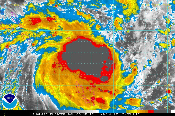
| Above: Blend of visible/infrared imagery for Cyclone Donna as of 1530Z (11:30 am EDT) Thursday, May 4, 2017. Overlaid are the predicted positions and Saffir-Simpson strength categories for Donna from the Joint Typhoon Warning Center. Image credit: NOAA/University of Wisconsin SSEC. |
Already the equivalent of a top-end Category 1 hurricane, Cyclone Donna is gathering strength in the Southwest Pacific and will make a run at the far-flung archipelago of Vanuatu. The Joint Typhoon Warning Center pegged Donna’s strength at 80 knots (90 mph) at 06Z Thursday (2:00 am EDT). Donna has built a solid shield of convection (showers and thunderstorms), and we can expect an eye to form in the next day or two.
 |
| Figure 1. Infrared satellite image of Hurricane Donna as of 1530Z (11:30 am EDT) Thursday, May 4, 2017. Image credit: NOAA. |
Donna’s gradual strengthening has a good chance of continuing over the next several days. Sea surface temperatures along its path are sufficiently warm, at 28 – 29°C (82 – 84°F), wind shear is relatively light (predicted to drop well below 20 knots, or 23 mph, for at least the next three days), and the atmosphere is moderately moist, with mid-level relative humidities of around 60 percent.
Forecast models are in close agreement that Donna will reach Category 2 or 3 strength, and the HWRF model suggests that 1-minute sustained winds could reach 120 knots (140 mph) by Sunday local time. That would put Donna solidly in the Category 4 range.
Fortunately, models have trended away from predicting a direct landfall on Vanuatu’s largest island, Esperitu Santu. With a more delayed recurvature expected, Donna now appears more likely to continue westward before arcing to the southeast well away from Esperitu Santu. The 06Z run of the HWRF model keeps Donna more than 100 miles offshore.
 |
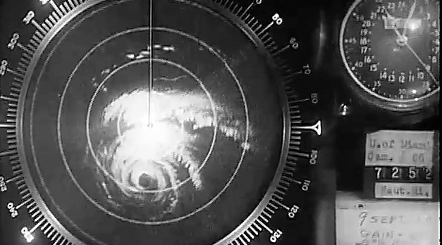
| Figure 2. Radar image of 1960's Hurricane Donna as it approached the Florida Keys on September 9. Image credit: University of Miami and NOAA/Atlantic Oceanographic and Meteorological Laboratory. |
For long-time hurricane watchers, another Donna may be coming to mind: Hurricane Donna of 1960, which struck the Florida Keys as a Category 4 (the fifth strongest U.S. landfall on record) and ground its way northward along the U.S. East Coast from Florida to New England. The name Donna has long been retired for the Atlantic, but obviously such retirements don’t apply on a global basis.
An early start to the Eastern Pacific hurricane season?
The Eastern Pacific hurricane season officially starts on May 15, when the National Hurricane Center will begin issuing its regular (four times daily) Tropical Weather Outlook. However, this year’s Eastern Pacific hurricane season may begin early. Both the GFS and European models have been consistently predicting over the past few days that a tropical depression will form in the waters off the coast of Guatemala early next week, with the storm moving to the northwest, parallel to the coast, late in the week. If this storm does form, it will be named Adrian.
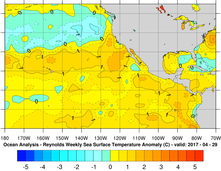
Sea surface temperatures of 29 – 30°C (84 – 86°F)—more than adequate for tropical development, and more than 1°C above average for the time of year—are widespread along the projected path of the potential storm.
 |
| Figure 3. Sea surface temperature anomalies (variations from average for this time of year) across the Northeast Pacific show widespread warmer-than-normal conditions. Image credit: NOAA/NWS National Hurricane Center. |
There is some support in the longer-range ensemble runs of the GFS and European model for a second tropical storm in the 1- to 2-week period, which would be named Beatriz. Keep in mind that skillfulness drops rapidly for model outlooks beyond about 10 days, even when ensemble members are in close agreement.
If Adrian does form, it could eventually make landfall on the Pacific coast of Central America or Mexico. There is even the possibility (showing up in a number of ensemble runs, but again in the long-range 1- to 2-week period) that the storm or its remnants could move into the Caribbean and attempt to reorganize. We have already had one named storm in the Atlantic (Arlene, in April), and climatology tells us that getting a second storm prior to the official start of the Atlantic season (June 1) would be truly exceptional. The earliest date on record for an Atlantic season’s second tropical storm was May 17—way back in 1887.
Jeff Masters contributed to this post.


