| Above: GOES-16 view of Tropical Storm Nate, at 10:45 am EDT Friday, October 6, 2017. Image credit: NOAA/RAMMB. GOES-16 imagery is considered preliminary and non-operational. |
A hurricane warning was in effect from Grand Isle, Louisiana, to the Alabama/Florida border on Friday as Tropical Storm Nate—already a deadly storm in Central America—gathered strength over the warm waters of the Northwest Caribbean. Nate was speeding north-northwest at 21 mph over the Western Caribbean, and the storm is expected to pass very close to the tip of Mexico’s Yucatan Peninsula on Friday evening as a strong tropical storm. Continued strengthening is predicted on Saturday as Nate traverses the Gulf of Mexico, and Nate is likely to be a Category 1 or Category 2 hurricane on Saturday night when it makes landfall on the U.S. Gulf Coast between Southeast Louisiana and the Florida Panhandle.
Dangerous heavy rains from Nate have affected large parts of Central America and the islands of the Western Caribbean. As of midday Friday, Nate had led to a total of 22 deaths in Central America, with another 24 people listed as missing. A personal weather station on the Pacific side of Nicaragua recorded 8.79” of rain from Nate as of 11 am EDT Friday. Satellite rainfall estimates show that Nate has dumped 8+” of rain on the Pacific side of Costa Rica, Nicaragua, and Panama, and also along the northern coast of Honduras and the eastern coast of the Yucatan Peninsula, in both Mexico and Belize.
 |
 Figure 1. Rio Baru overflows and destroys a home in Dominical, Puntarenas Province, Costa Rica, as Tropical Storm Nate hits the area on Thursday, October 5, 2017. (Instagram/@tywebbphish) |
 |
| Figure 2. Microwave satellite view of Nate taken at 7:58 am EDT Friday, October 6, 2017 (colored areas, showing where the heaviest precipitation is occurring), overlaid on a GOES-13 infrared satellite image from 7:30 am EDT Friday. Nate appeared to be building the southern portion of an eyewall to the south of its center, but the winds measured by the Hurricane Hunters in that area were 40 mph or less. Image credit: Naval Research Laboratory. |
Belize radar and satellite imagery late Friday morning showed an increase in the organization and coverage of Nate’s spiral bands, which were sprawled out over the entire Western Caribbean, from Nicaragua to Cuba. An Air Force and a NOAA hurricane hunter aircraft were in Nate on Friday morning, and found that the pressure was falling and the winds were slowly increasing. Eye penetrations at 7:24 am, 9:03 am, and 10:51 am EDT found the central pressure holding nearly steady at 997 – 998 mb, but the surface winds had risen to 50 mph, mainly in bands well to the east of the center. Though not noted on the center Vortex Data Message, visible and microwave satellite imagery suggest that Nate may be attempting to build an eyewall along the south side of the center.
Conditions were very favorable for development, with low wind shear less than 5 knots, sea surface temperatures (SSTs) a very warm 30°C (86°F), and an unusually moist atmosphere with a mid-level relative humidity of 85%. Nate was traversing an area with exceptionally high ocean heat content in excess of 100 kilojoules per square centimeter, favorable for fueling rapid intensification.
Short-term forecast for Nate
Nate is expected to maintain its fast forward speed of about 21 mph through Saturday, which likely does not give it enough time to become a hurricane before reaching Mexico’s Cozumel/Cancun area late Friday afternoon/Friday evening. The structure of the storm late Friday morning did not favor rapid intensification, since Nate lacked an inner core, and the strongest winds were occurring more than 50 miles to the east and northeast of the center. Looking further ahead, the 12Z Friday run of the SHIPS model predicted that conditions for intensification would be favorable through landfall on the U.S. Gulf Coast Saturday night, with wind shear low to moderate (5 - 15 knots), SSTs a warm 29 - 30°C (84 - 86°F), and an unusually moist atmosphere with a mid-level relative humidity of 80 – 85%. On Saturday, Nate will be passing along the edge of an area of high ocean heat content in the Gulf of Mexico, associated with a warm eddy at the northern end of the Loop Current.
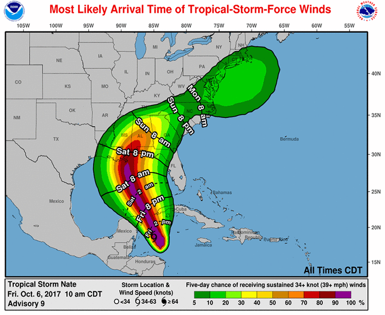
The Friday morning runs of our top five intensity models predicted Nate would be a strong tropical storm or weak Category 1 hurricane with 70 – 80 mph winds at landfall Saturday night on the U.S. Gulf Coast. Given the way this season has gone, residents would be wise to leave some margin of error and prepare for a Category 2 hurricane, and to keep in mind that Nate could be strengthening up until it reaches the coast on Saturday night. At landfall Saturday night on the Gulf Coast, Nate's tropical storm-force winds are expected to extend about 110 miles to the east of the center, and 70 miles to the west of the center. As we saw with Hurricane Irma in Florida, these winds can team up with heavy rains to bring down trees and power lines and lead to widespread power outages.
 |
| Figure 3. The 11 am Friday NHC forecast for the probability of tropical-storm-force winds for Nate. The coast from Southeast Louisiana to the Alabama/Florida border was given a greater than 70% chance of tropical storm-force winds of 39+ mph, with those winds most likely to arrive Saturday night. Image credit: NOAA/NWS/NHC. |
Surge threat from Nate
A storm surge warning is up for the Gulf Coast from Morgan City, LA to the Alabama/Florida border, as well as along the northern and western shores of Lake Pontchartrain. In these areas, 4 – 7 feet of inundation were predicted by NHC in their 11 am EDT Friday advisory, assuming that Nate were to arrive during high tide. Because the daily high tides in this region occur during the pre-dawn hours, it is quite possible that Nate will reach the coast within several hours of high tide. High tide in Mobile, Alabama is at 1:46 am local time Sunday, and it will be one of the highest high tides of the year, due to the full moon. Low tide is at 10:12 am Saturday. At Shell Beach, LA, on the east side of New Orleans, high tide is at 4:29 am local time Sunday, and low tide is at 12:14 pm Saturday. Tidal range between low and high tide is 1 - 1.3’ along the central Gulf Coast, so the timing of Nate’s storm surge with respect to the high tide can cause an additional foot or so of flooding.
Nate's center will be moving close enough to New Orleans to raise concerns about the city's troubled storm drainage network. On Thursday, New Orleans mayor Mitch Landrieu advised residents of New Orleans inside the city’s levee system to gather essential supplies and be prepared to take shelter, and he strongly urged residents outside the levee system or in low-lying areas to move to higher ground. Two of the five powerful turbines at the heart of the city’s drainage system are currently out of service, after a destructive early-August flood that struck when three of the turbines were out of commission (a fourth went offline days later). About 90% of the city’s 100-plus drainage pumps are in service, and 26 emergency generators were acquired after the August storm, according to the New Orleans Times-Picayune. As the paper reported in August, much of the electrical and mechanical infrastructure in the drainage system is more than a century old.
The surge from Nate will arrive quickly, and peak in the middle of the night, so residents need to take the surge threat seriously and prepare accordingly. The last hurricane to make a direct hit on the LA/MS region was Hurricane Isaac in 2012. This Category 1 storm moved northwest through the Gulf and made landfall with 80-mph sustained winds at the mouth of the Mississippi River on the evening of August 28, 2012, only about 12 hours after it reached hurricane strength. Isaac had a large circulation, with tropical-storm-strength winds spanning about 350 miles, and the hurricane funneled enough water into the surge-prone central Gulf Coast to produce a storm surge of 11.03’ at Shell Beach, LA; 6.69’ at Pilottown, LA, near the mouth of the Mississippi; and 8’ at Waveland, MS. Major storm-surge flooding occurred from southeast Louisiana to Alabama, including the New Orleans area. Here are the top 10 surges on record for Shell Point, LA, as compiled by storm surge expert Dr. Hal Needham in 2012 from SURGEDAT database. (Storm tide is the combination of storm surge and the astronomical tide.)
Rank Storm Year Max Water Level (ft)
1 Katrina 2005 18.7 (storm surge)
2 Unnamed 1915 11.6 (storm tide)
3 Unnamed 1947 11.2 (storm tide)
4 Camille 1969 11.06 (storm tide)
5 Isaac 2012 11.03 (storm surge)
6 Flossy 1956 10.9 (storm tide)
7 Gustav 2008 9.53 (storm surge)
8 Betsy 1965 9.34 (storm tide)
9 Ike 2008 7.51 (storm surge)
10 Unnamed 1901 6.7 (storm tide)
Isaac produced roughly $2.2 billion in U.S. damage, including about $970 million in insured losses. Nate is expected to arrive on the LA/MS/AL coast as a hurricane smaller than Isaac, but roughly as strong or perhaps stronger in terms of peak winds, so it is entirely plausible that Nate could become the nation’s fourth billion-dollar hurricane of 2017, after Harvey, Irma, and Maria.
Nate’s rainfall
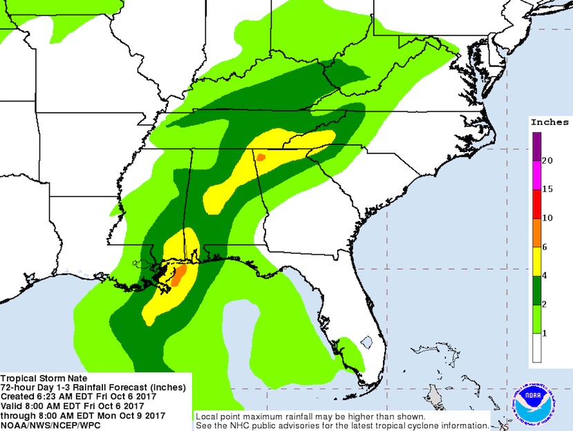
Nate’s rapid motion will limit the total amount of rainfall at any one spot, and the overall accumulations should be less than those observed during Isaac. However, Nate is embedded in a very moist atmosphere, and torrential rain could still fall in short periods. Nate’s quick-hitting rains could exacerbate the strain on the levee system in and around New Orleans, especially if Nate tracks toward the western end of its forecast range. Localized rainfall totals of 6 – 10” are expected close to Nate’s landfall location, and a stripe of 4 – 6” totals will extend well into the southern Appalachians into Sunday night, perhaps including the Atlanta area. Rains of 2 - 5" may proceed into the northern Appalachians and into southern New England on Monday as Nate tracks quickly northeast as a fast-weakening tropical cyclone.
Bob Henson co-wrote this post.
 |
| Figure 4. Predicted 3-day rainfall totals from Tropical Storm Nate for the period from 8 am EDT Friday, October 6, through 8 am EDT Monday, October 9, 2017. Additional heavy rain may extend further north with Nate or its remnants beyond this forecast period on Monday, perhaps as far as southern New England. |


