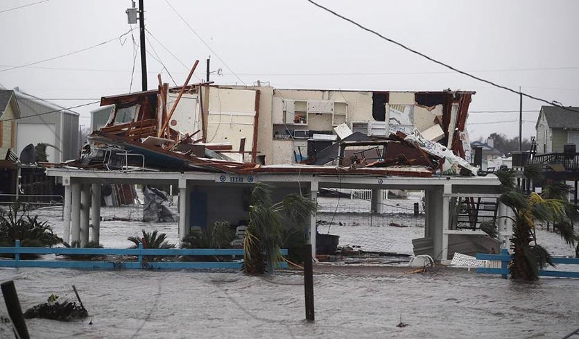
| Above: A damaged home in Rockport, Texas, as seen on August 26, 2017. Image credit: Joe Raedle/Getty Images. |
Hurricane Harvey powered ashore along the central Texas coast near Rockport (population 9,000) near 10 pm CDT Friday night, as a Category 4 storm with 130 mph winds. Heavy damage was reported in Rockport (located about 40 miles northeast of Corpus Christi), and at least ten people were injured there from collapsed roofs. Harvey was the first Category 4 storm to strike the U.S. since Hurricane Charley in 2004, and the first major landfalling hurricane (Category 3 or stronger) since Hurricane Wilma in 2005. At 1 pm CDT Saturday, Harvey had weakened to a tropical storm with 70 mph winds, and was centered about 30 miles to the northwest of where it made landfall. Harvey was nearly stationary, moving at just 2 mph to the north-northwest—a sign of potential trouble in the days ahead from relentless rounds of torrential rainfall.
 |
| Figure 1. GOES-16 visible satellite image of Hurricane Harvey taken at 6:15 pm CDT August 25, 2017. At the time, Harvey was a Category 4 storm with 130 mph winds, about to make landfall near Rockport, Texas. Image credit: NOAA/RAMMB. |
 |
| Figure 2. Landfall locations of all 25 Category 4 and 5 hurricanes to hit the continental U.S. since 1851, including Hurricane Harvey. Florida has had the most Cat 4 and 5 landfalls (12), followed by Texas (7), and South Carolina (3). Harvey is tied for 14th place for lowest central pressure of a landfalling U.S. hurricane, according to CSU’s Dr. Phil Klotzbach. Image credit: Phil Klotzbach. |
Harvey brings 5th highest storm surge on record to Port Lavaca: 7 feet
The highest storm tide (the combined height of the storm surge and the tide above mean sea level) recorded by a NOAA tide gauge from Harvey’s landfall was 7.0 feet at Port Lavaca, measured at 3:48 am CDT Saturday. The storm surge likely reached as high as 10 – 12 feet in nearby regions where no tide gauges were present, according to a Saturday morning blog post by storm surge expert Dr. Hal Needham. This was the city’s highest storm surge since the record 18.5’ water level from Hurricane Carla (1961), and their fifth highest storm surge since 1900. Mean sea level in the region (as measured by the Corpus Christi tide gauge) has risen approximately 1.48 feet since 1900--mostly due to global warming and land subsidence--making it easier for a storm surge like Harvey’s to push farther inland and do more damage.
Corpus Christi measured a peak storm tide from Harvey of 4.07 feet, which ranked as their 17th highest water level on record. Port Aransas had a peak storm surge of 4.75’, and Rockport’s peak storm tide of 2.52’ above MHHW was the 8th highest water level since records began in 1948.
 |
| Figure 3. Time series of storm tide (surge + tide) levels at Port Lavaca above Mean Sea Level (MSL) from 1900-2017 (118 years). Hurricane Harvey likely generated a 10-12 foot storm tide near Port Lavaca, although the highest observed level reported was 7.0 feet above MSL on Saturday, August 26, at 3:48 AM CDT. Harvey generated the highest storm tide at Port Lavaca since Hurricane Carla in 1961, and the 5th highest storm tide since 1919. Observations are graphed chronologically from oldest (left) to newest (right). Absence of low-magnitude storm tide events before Ella (1958) is influenced by under-reporting, and does not necessarily indicate a lack of actual storm tide events. Image credit: Hal Needham. |
Continued storm surge flooding in Galveston Bay a major concern
Harvey’s counter-clockwise circulation is bringing strong onshore winds to the coast near Houston and Galveston, which is driving a major storm surge into Galveston Bay. As of 2:30 pm CDT Saturday, storm surge heights at four tide gauges in the bay and connecting waters were 3.0 – 4.0’. As Harvey continues to pound the Houston area with torrential rains over the next few days, high storm surge levels will prevent rivers from properly draining rainwater into the bay, causing the rivers to back up and create widespread flooding in the nation’s fourth largest city. See our post from Friday on the potential multi-day risks to the Houston Ship Channel, western Galveston Bay, and adjoining areas. You can use our Wundermap with the “Storm Surge” layer turned to see a map with the surge values plotted, and overlay the “Weather Stations” layer to see observed precipitation and winds.
Harvey brings highest August precipitable water levels on record to Corpus Christi
Harvey brought huge amounts of moisture into Texas, with the 0Z Saturday, August 26, balloon sounding at Corpus Christi measuring the highest amount of precipitable water (PW) on record for the month of August: 2.78”. PW records extend back to 1950. Precipitable water is the amount of rain that would fall if one were to condense out all of the water vapor in a column above the ground. Corpus Christi was not able to do the 12Z Saturday balloon launch, but the amount of moisture over the central coast of Texas remains at near-record levels, according to model and satellite estimates. A NOAA research balloon launched into Harvey at 2:16 am CDT Saturday recorded a remarkable 3.26” of PW, a rarely-seen level of atmospheric moisture for the U.S.
 |
| Figure 4. Rainfall amounts for the 24 hours through 7:00 am CDT Saturday, as estimated by a multisensor blend that includes rain gauge and radar data. Totals exceeding 10” occurred near the core of Harvey, north of Corpus Christi, and in a persistent rainband well northeast of the center. Image credit: NOAA/NWS/AHPS. |
The forecast: catastrophic, life-threatening flooding expected into next week as Harvey stalls out
An extremely serious situation with few if any close parallels in modern U.S. hurricane history is taking shape over the southeast third of Texas. Computer models remain in strong agreement that the steering currents around Harvey will remain weak through at least Wednesday. As a result, Harvey will spin down while stalled for several days within 100 miles of the central Texas coast (see Figure 5). Even as its top winds decrease, Harvey will continue to pump enormous amounts of moisture into south central and southeast Texas, producing relentless bands of showers and thunderstorms (convection) across a wide swath that will likely include the Houston area. The 12Z Saturday run of our most reliable hurricane tracking model, the European, predicts that Harvey will edge offshore on Monday and Tuesday, which would keep the storm from weakening, and potentially allow some modest re-intensification.
| Figure 5. WU depiction of NHC 5-day outlook for Hurricane Harvey as of 10:00 am CDT Saturday, August 26. The concentric circles indicate how slowly Harvey is expected to move over the next few days. |
Multiple computer models over the last several days have predicted that truly astonishing amounts of rain will fall near and northeast of Harvey’s center, including localized totals above 40” and widespread amounts between 10” and 30”. Unfortunately, the models are still resolute in that diagnosis, and what we know about tropical cyclone behavior only confirms what the models are telling us. Even in the short term, the mesoscale HRRR model (Figure 6) predicts that intense rainbands will continue to train across the general vicinity of Houston, possibly dumping more than 20” of rain by Sunday morning. All-time record crests are already being projected for several bayous and rivers in the area, including Buffalo Bayou in Houston on Sunday and the Brazos River at Richmond on Monday. It is easy to see how 40” or more could pile up in some locations (as warned by the NWS/Houston office) if such a pattern persists for several days, even as Harvey weakens. The Addicks Reservoir in west Houston, which feeds into Buffalo Bayou, was emptied earlier this week in advance of Harvey—a smart move, but not enough by itself to prevent massive flooding.
 |
| Figure 6. Rainfall projected by the High-Resolution Rapid Refresh model (HRRR) for the entire 18-hour model run from 9:00 am CDT Saturday, August 26, 2017, through 3:00 am CDT Sunday. The persistent band of storms east of Harvey runs through Harris County, including Houston, in this model run, producing rains of well more than 12” through early Sunday. Image credit: tropicaltidbits.com. |
Beyond about Tuesday, there is increasing disparity on the future of Harvey, which is likely at that point to be a tropical depression or a weak tropical storm not far from the Texas coast (as predicted by the 10 am CDT Saturday outlook from NHC). Harvey is being sandwiched between a strong upper-level ridge over the western U.S. and another strong ridge extending from the subtropical Atlantic across the Gulf of Mexico. Given these two factors, any longer-term motion is likely to be either southwest, toward the Rio Grande (as suggested by the 06Z and 12Z Saturday GFS runs) or toward the northeast (as indicated in the 00Z Saturday European run and the official NHC forecast from Saturday morning). It is also not out of the question that Harvey will remain more or less in place through midweek or even longer (as projected in the 00Z Saturday GFS run). The longer that steering remains weak, the harder it is to know how the pattern will ultimately resolve. Regardless of Harvey’s ultimate track, there is very little doubt that Texas is in for one of the worst rainfall and flood events in its history. The resulting rainfall is very likely to produce widespread, devastating, and potentially catastrophic flooding. The situation in Houston is particularly concerning, given that city's vast size and population and its well-known vulnerability to flooding.
For the first time ever, the NOAA/NWS Weather Prediction Center has issued “high risk” advisories for excessive rainfall for three consecutive days—Saturday, Sunday, and Monday—all for the area near and just east of Harvey’s core (see Figure 7).
Good sources for tracking the situation in Houston in real time include the NWS/Houston website, the office's Twitter and Facebook feeds, Space City Weather, and the Houston Chronicle.
 |
| Figure 7. Outlooks for severe weather (top) and excessive rainfall (bottom) for Saturday, Sunday, and Monday (left to right). Tornadoes will be possible all three days in the slight-risk area. Image credits: NWS/SPC and NWS/WPC; graphic compiled by James Correia Jr., @jimmyc42. |
92L disorganized over Florida
Tropical disturbance 92L was located over Florida on Saturday. Satellite images showed that 92L had little heavy thunderstorm activity and very little organization, and high wind shear of 30 - 35 knots was hindering development. The system is expected to move to the northeast over Florida over the weekend, spreading heavy rains of 3 – 5”, and may have better chances of development on Monday and Tuesday, when it will begin accelerating to the northeast, very close to the coasts of South Carolina and North Carolina. The best chances for development may come on Monday, when wind shear is expected to drop to 20 – 25 knots, according to the 12Z Saturday run of the SHIPS model. At that time, 92L is expected to near the coast of South Carolina. In its tropical weather outlook issued at 8 am EDT Saturday, the National Hurricane Center gave 92L 2-day and 5-day odds of development of 40% and 50%, respectively. The storm will bring rough surf and strong winds to the coasts of Florida, Georgia, South Carolina, and North Carolina over the next few days.
The next African tropical wave may develop
A tropical wave predicted to emerge from the coast of Africa on Sunday has the potential to develop into a tropical depression by Friday over the central tropical Atlantic, according to the 0Z and 12Z Saturday runs of our top three models for predicting tropical cyclone genesis, the European, GFS, and UKMET models. The wave is predicted to head west to west-northwest at about 15 mph. The earliest the wave would reach the northern Lesser Antilles Islands would likely be Tuesday, September 5, but the storm may turn northwest and miss the islands entirely. In its tropical weather outlook issued at 2 pm EDT Saturday, the National Hurricane Center gave this new wave 2-day and 5-day odds of development of 0% and 20%, respectively.
Bob Henson co-wrote this post.


