| Above: Tornado damage to a house in Minneapolis, Kan. on Tuesday, May 1, 2018. Image credit Eldon Clark Jr., via weather.com. |
The risk of tornadic storms will be on the wane this weekend, as a potent U.S. severe weather pattern began to wind down. A total of 43 tornado reports had been collected by the NOAA/NWS Storm Prediction Center (SPC) as of early Friday morning: 21 on Tuesday, 15 on Wednesday, and 7 on Thursday. Despite a couple of large, highly visible twisters, the week’s severe weather had produced no deaths or serious injuries through late Thursday. (The only tornado-related fatalities of the year thus far were two on February 24 and one on April 13, according to SPC.) Still, enough destruction was wrought by the tornadoes, large hail, and nontornadic high winds to yield at least $200 million in damage, according to estimates on Thursday from the reinsurance broker Aon Benfield.
Several intense supercell thunderstorms spun across Oklahoma on Wednesday evening. Baseball-sized hail was reported near Sweetwater, and winds reportedly gusted as high as 106 mph near Frederick. Despite looking very ominous on radar for brief periods, the storms were numerous enough to interfere with each other, and there were only a few tornado reports. An EF1 twister skipped across northeast sections of Norman on an eight-mile path, rattling residents and coming within about six miles of the SPC offices.
Damage surveys are pending on several other tornadoes from Wednesday across southwest Oklahoma, as well as one in southeast Oklahoma on Thursday morning. “Limited structures to damage and some flooding are making the survey challenging,” tweeted the NWS office in Norman on Thursday.
Winds gusting to 92 mph near Pratt, KS, took down several power poles and unroofed two buildings. One Kansas county saw its second tornado in as many days (see tweet below). Wednesday’s twister was much less eye-popping than the wedge that preceded it on Tuesday, though.
A #tornado touched down in one unlucky Kansas county two days in a row Tuesday & Wednesday. That isn't as unusual as it sounds. https://t.co/3YhH4FeYec pic.twitter.com/lUSjPaex1g
— Jonathan Erdman (@wxjerdman) May 3, 2018
Strong thunderstorm winds also swept across the Chicago area on Wednesday afternoon. Wind gusts to 67 mph were reported at Midway Airport in southwest Chicago, as reported by weather.com. Late Thursday, a severe thunderstorm moved through northern parts of the New York metro area, bringing wind gusts of 67 mph near the Tappan Zee Bridge north of the city.
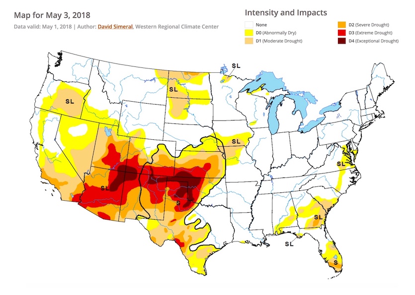
Unfortunately, this week’s storms were too far east to provide major relief from the grinding drought from the Southwest across the Southern High Plains. Most areas from western Oklahoma to eastern New Mexico have gotten an inch or less of precipitation since mid-October.
 |
| Figure 1. About 16% of the contiguous U.S. was experiencing extreme to exceptional drought as of May 1, 2018, according to the May 3 installment of the U.S. Drought Monitor. Image credit: National Drought Mitigation Center. |
Tornadoes should be few and far between in the next week
Even though May is the nation’s peak tornado month, we’re now likely to make it through at least the first third of the month without a major outbreak. As of Thursday, the SPC outlooks for Days 2 through 8 (Friday through Thursday, May 4–10) showed nothing more than marginal risk areas. Update: At 9 am EDT Friday, SPC placed Vermont and most of New York in an enhanced risk area for severe weather through early Saturday. Strong non-tornadic winds are the main threat, although tornadoes are possible.
There’s high confidence in a period of quietude ahead based on several factors:
• The slow-moving front that’s triggered this week’s storms is now pushing toward the East Coast, which will shunt the richest Gulf moisture out of the nation’s midsection.
• The polar jet stream will be pulling northward, leaving most of the nation in a long stretch of fairly weak flow that’s ill-suited for supporting organized severe weather.
• Deep moisture will be slow to return from the Gulf in the weak low-level flow.
All in all, next week should bring at least a few periods of mild-to-warm temperatures and tranquil conditions to most of the U.S., a spell of beautiful weather that should be much appreciated by millions in the Midwest, South, and Northeast who endured one of the coldest Aprils on record. We’ll have more on that amazing month in a post next week. As if to accentuate the warm shift, temperatures rocketed to record highs this week across the Northeast (see below).
Jeff Masters will have an update on global air quality Friday afternoon, in honor of 2018 Air Quality Awareness Week.
It seems like parts of the Eastern US have skipped spring and gone directly to summer. Here are the record high temperatures set the last 2 days. pic.twitter.com/b5xWqgTqYZ
— NWS Eastern Region (@NWSEastern) May 3, 2018


