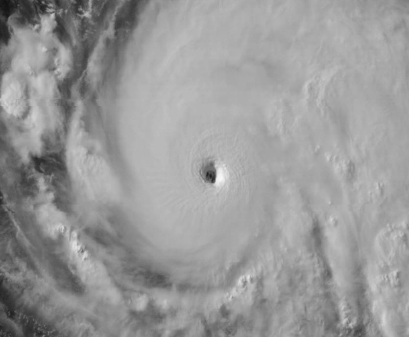
| Above: MODIS image of Hurricane Fernanda taken at 5:30 pm EDT, July 14, 2017, from NASA’s Aqua satellite. At the time, Fernanda had just been designated a Category 4 hurricane. Image credit: NASA. |
After vaulting from tropical storm to Category 4 status in a mere 36 hours, Hurricane Fernanda continued churning through the Northeast Pacific on Saturday. Thankfully, Fernanda is far from land, and was located about 1200 miles southwest of the southern tip of Mexico's Baja Peninsula at 11 am EDT Saturday. Fernanda was headed westwards towards Hawaii at 13 mph. Fernanda reached a peak intensity of 145 mph winds on Friday night through Saturday morning, and was tied with Tropical Cyclone Enawo as Earth's second strongest tropical cyclone so far in 2017 (Enawo hit Madagascar in March, killing 81.) The strongest thus far is Cyclone Ernie, which raged well northwest of Australia in April with peak winds that reached 150 mph as rated by the Joint Typhoon Warning Center.
By 11 am Saturday, Fernanda's top winds had weakened slightly to 140 mph, thanks to an eyewall replacement cycle.
 |
Figure 1. GOES-16 image of Hurricane Fernanda taken at 8 pm EDT Friday, July 14, 2017. At the time, Fernanda was a Category 4 storm with 145 mph winds. Friday gave us the first-ever images of a Category 4 storm gathered by the high-resolution GOES-16 satellite, whose data are still preliminary and non-operational. Image credit: NOAA/CIRA/RAMMB. |
Light wind shear, warm water, and a moist atmosphere allowed Fernanda to intensify on Thursday and Friday even more quickly than many eye-opening model runs had been predicting. At midday Thursday, when Fernanda was still a minimal hurricane, the 18Z Thursday SHIPS rapid intensification index gave the storm a 34% chance of gaining 55 knots of strength (70 mph) in 48 hours. Fernanda ended up beating the odds and beating the clock, too, as it gained 70 mph of strength in just 36 hours:
11:00 am EDT Thursday 75 mph
5:00 pm EDT Thursday 80 mph
11:00 pm Thursday 85 mph
5:00 am Friday 100 mph
11:00 am Friday 115 mph
5:00 pm Friday 130 mph
11:00 pm Friday 145 mph
Arriving on the scene only a week after Category 3 Hurricane Eugene, Fernanda is the Eastern Pacific’s second major hurricane of the year—a milestone that on average isn’t reached till the third week of August. Eugene was a fast intensifier, but also a fast weakener: its entire lifespan as a hurricane spanned less than 48 hours. In contrast, Fernanda won’t be taking its bows anytime soon.
Fernanda was at a very southery latitude of 11°N on Saturday morning, and its westward to west-northwestward track through Monday will keep it over very warm waters of 28 - 29°C--about 0.5°C above average. Wind shear will remain quite low (less than 10 knots), so the main question mark in Fernanda’s strength over the weekend is how quickly it will recover from the eyewall replacement cycle that was underway Saturday morning. The old eyewall with a diameter of 10 miles was collapsing, to be replaced by a new eyewall with a larger diameter of 30 miles. Once this process is complete, reintensification can occur, and it is possible that Fernanda could reach Category 5 status on Sunday.
By Monday afternoon, Fernanda will be on a gradual decline, as it moves over cooler waters and into a drier, more stable atmosphere. The weakening should be gradual, though, and it’s possible that Fernanda will be approaching the Hawaiian Islands as a tropical storm by the weekend of July 22 - 23.
Quiet in the Atlantic
Conditions are tranquil in the Atlantic, where dry Saharan air continues to predominate, and no tropical development is expected through Wednesday. There was a tropical wave located midway between the coast of Africa and the Lesser Antilles Islands on Saturday morning, near 10°N 40°W, that we should keep an eye on, though. Some of the members of the 0Z Saturday GFS ensemble forecast showed this wave developing by mid-week, when it will be moving through the Lesser Antilles Islands.
Greg on the way in the East Pacific?
A new system in the East Pacific, Invest 97E, could become a long-lived tropical storm in the coming days well southwest of Mexico. In their 8 am EDT Saturday Tropical Weather Outlook, The National Hurricane Center gave 97E a 40 percent chance of becoming at least a tropical depression by Monday, and a 60 percent chance by Thursday. Starting off at a higher latitude than Eugene and Fernanda, this next system—which will be named Greg if it develops—will be traversing cooler waters and is unlikely to become a significant hurricane as it tracks far out to sea.
The Don and Hilary Show?
If 97E does become Greg next week, it will set up the potential for a naming juxtaposition right out of central casting. The next two names on the Atlantic and East Pacific lists, respectively, would be Don and Hilary.
Bob Henson wrote most of this post.


