| Above: Mud and water flow through Freetown, Sierra Leone, on Monday, Aug. 14, 2017, following torrential rains in the area. Image credit: Society 4 Climate Change Communication via AP. |
A catastrophic flash flood and mudslide early Monday took at least 300 lives in and near the Sierra Leone capital of Freetown, according to reports from the International Federation of Red Cross (via the UK Guardian). Hundreds more may have died. This appears to be the deadliest natural disaster on record for Sierra Leone, according to the EM-DAT international database. A total of 103 people were killed in a flood on August 13, 2009.
Satellite loops show that intense thunderstorms affected Sierra Leone between 1700 GMT Sunday, August 13, and 0500 GMT Monday, August 14. Local time in Sierra Leone is the same as GMT, so these storms were an overnight event, which no doubt made the flooding more dangerous. These storms were not directly associated with the tropical wave known as Invest 91L, which moved off Africa over the weekend. However, this system as well as the one that eventually led to Tropical Storm Gert are among the easterly waves that have moved through Sierra Leone in recent days, contributing to saturated soils in the Freetown area. According to satellite rainfall estimates, the Freetown region received more than 4” (100 mm) of rain during the 7-day period ending August 12.
Medics are certain the death toll will continue to rise after mass floods. Piles of corpses at morgues #Freetown pic.twitter.com/CMZZDVjEjV
— Patrick Galey (@patrickgaley) August 14, 2017
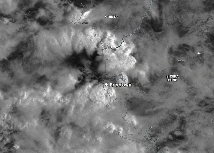 |
| Figure 1. VIIRS moonlight visible satellite image of heavy thunderstorms over Freetown, Sierra Leone, at approximately 0200 UTC Monday, August 14, 2017. Image credit: NASA. |
One of the wettest spots on Earth in July and August
Each year, tropical waves moving across Africa dump torrential rains on the African Sahel and nearby regions, including Sierra Leone, before moving into the Atlantic as “Cape Verde waves,” where some of them go on to become tropical storms or hurricanes. In fact, Sierra Leone is one of the wettest places on Earth during the months of July and August (see Figure 2). For the climatological period 1961-1990 (the most recent available), the average rainfall for Freetown was 28.91” (734.3 mm) in July and 31.15” (791.1 mm) in August. That makes for an astounding two-month total of more than 60” in a typical year.
This summer, the waves moving off Africa and through the Atlantic have been unusually strong, leading to a very active early season across the Main Development Region of the Atlantic. Tropical Storm Bret, which developed east of the Lesser Antilles in June, was among the earliest Cape Verde tropical storms on record. Bret was followed in July by Don, another unusually early Cape Verde tropical storm.
The heaviest downpours in many parts of the globe have become heavier in recent decades, a trend attributed to human-produced climate change and expected to continue. A study led by Christopher Taylor (UK Centre for Ecology and Hydrology), published this spring in the journal Nature, finds that the Sahel’s most intense mesoscale convective systems (organized clusters of thunderstorms) have tripled in frequency since 1982. The recovery of Sahel rainfall since the 1980s only explains a small part of this trend, according to the study authors. They argue that Saharan warming is helping to intensify convection within the MCSs through increased wind shear and changes to the Saharan air layer. “The meridional gradient is projected to strengthen throughout the twenty-first century, suggesting that the Sahel will experience particularly marked increases in extreme rain,” the study concludes.
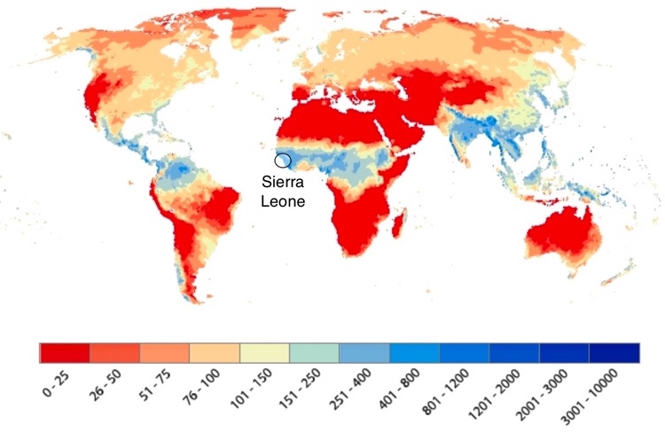 |
| Figure 2. Average precipitation (in millimeters) during August for the period 1985-1999. Image credit: UK/NERC Centre for Ecology & Hydrology. |
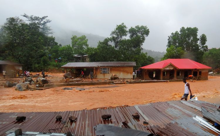 |
| Figure 3. A resident walks through floodwaters past a damaged building in an area of Freetown on August 14, 2017, after landslides struck the capital of the west African state of Sierra Leone. At least 312 people were killed and more than 2,000 left homeless when heavy flooding hit Sierra Leone's capital of Freetown, leaving morgues overflowing and residents desperately searching for loved ones. An AFP journalist at the scene saw bodies being carried away and houses submerged in two areas of the city, where roads turned into churning rivers of mud and corpses were washed up on the streets. Image credit: Saidu Bah/AFP/Getty Images. |
A flood exacerbated by urban pressures and poverty
Apart from any climate-change-related trends, the natural tendency for Freetown to flood has become steadily worse as a result of the city’s burgeoning growth and insufficient sewage and drainage systems. The population of the Freetown area is now more than 1 million, a tenfold increase since 1960, when the colonial period ended. Much of the growth has been in the form of more than 60 informal settlements surrounding the colonial central city, along the coastline and in the hills just above town. Many of the shacks in these settlements are poorly built, with little or no defense against flooding. Not only do these settlements typically lack the drainage needed to avoid floods, but the deforestation of hillsides to make room for homes is a classic risk factor that allows floodwaters to rampage more easily—as seen in the catastrophic floods of recent decades across largely deforested Haiti.
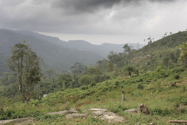 |
| Figure 4. Felled trees lie on the mountainside just outside Freetown on November 27, 2006 in Sierra Leone. Deforestation has become a huge problem in the area around Freetown. After the decade-long civil war ended in 2002, the population of the Freetown area swelled, causing people to encroach on forested areas. Image credit: Chris Jackson/Getty Images. |
The largest of the informal settlements around Freetown is Kroo Bay, with a population of around 10,000. “Each year during the rainy season, Kroo Bay community experiences flooding more than once, and on each occasion floods invade homes washing away furniture, utensils and clothes,” reported the Sierra Leone Concord Times in 2015.
Even where sewage systems are present, “drains are perennially blocked by natural and man-made waste,” according to a 2015 report by the Africa Research Institute. The report called for efforts to unblock drains, improve weather prediction, and implement and uphold a moratorium on building in the forested hillsides. On July 20, 2017, the Sierra Leone Parliament unanimously passed the Sierra Leone Meteorological Agency Act, replacing a department “that had outlived its usefulness over 80 years ago", reported by Awareness Times, a Freetown newspaper.
The forecast does not look good for a quick recovery in Freetown. Models are projecting more heavy rains to arrive, especially from late Tuesday into Wednesday.
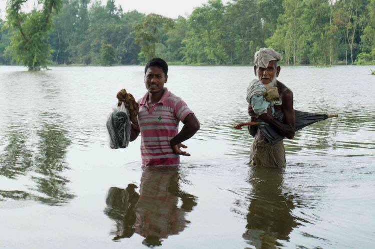 |
| Figure 5. Bangladeshi walk in water in an area submerged by flood in Kurigram, northern Bangladesh, on August 14, 2017. At least 175 people have died and thousands have fled their homes as monsoon floods swept across Nepal, India and Bangladesh, officials said on August 14, warning the toll could rise as the extent of the damage becomes clear. Image credit: Stringer/AFP/Getty Images. |
At least 175 killed across South Asia by monsoon floods
The wet season is also proceeding in full force across South Asia, where monsoon-related flooding has reportedly taken at least 175 lives, many of them across the higher terrain of northern India and southern Nepal. Officials on Monday were still trying to assess the full extent of the damage, according to the Associated Press (via weather.com). Major impacts are also being felt across the lowlands of Bangladesh, where some 368,000 people are in shelters. Another 200,000 are being housed in relief camps in northeast India.
Hundreds of people die every year in monsoon-related flooding across South Asia. A June 2013 flood in north India killed some 5700 people, making it the nation’s deadliest flood disaster in recent years. As of August 14, this year’s monsoon had produced 3% less rainfall than average for India as a whole, but 6% more than average across east and northeast India.
Jeff Masters contributed to this post.


