| Above: GOES-East satellite image of Invest 90L over the northwest Caribbean, Cayman Islands, Cuba and Florida, taken at 11:15 am EDT May 22, 2018. Image credit: NOAA/RAMMB. |
An area of disturbed weather, associated with a broad surface low centered just east of Belize in the western Caribbean, is spreading showers and thunderstorms over Cuba, the Cayman Islands and Florida. This system was designated 90L by the National Hurricane Center (NHC) on Monday afternoon—the first “invest” of the year in the Atlantic (an "invest" is an area of interest that is worthy of having NHC's special hurricane forecast models make forecasts for).
Invest 90L is embedded in an unusually moist atmosphere (with precipitable water levels near 2”), but the showers and thunderstorms associated with 90L are very disorganized, as seen on satellite loops. This activity will move slowly northward at about 5 mph through the central and eastern Gulf of Mexico over the next few days, where sea surface temperatures (SSTs) range from 25 - 28°C (77 - 82°F)—near the lower limit of 26.5°C (80°F) that is typically needed for a tropical depression to form. The system will be moving over these marginally warm waters for several days, and has the potential to gradually acquire tropical characteristics and become a warm-cored tropical or subtropical depression by the weekend. Wind shear over the system was a high 20 – 40 knots on Tuesday, and was predicted to stay high through at least Wednesday, making development unlikely until Thursday at the earliest.
The Madden-Julian Oscillation (MJO), a pattern of increased thunderstorm activity near the Equator that moves around the globe in 30 - 60 days, and which can increase the odds of tropical cyclone formation when it is strong and located in the proper location, is predicted to be in a location that favors tropical cyclone formation in the Gulf of Mexico and Western Caribbean during the coming week.
In a special 8 am EDT Tuesday Tropical Weather Outlook, the National Hurricane Center gave the system 2-day and 5-day odds of development of 0% and 40%, respectively. The first name on the Atlantic list of storms for 2018 is Alberto.
 |
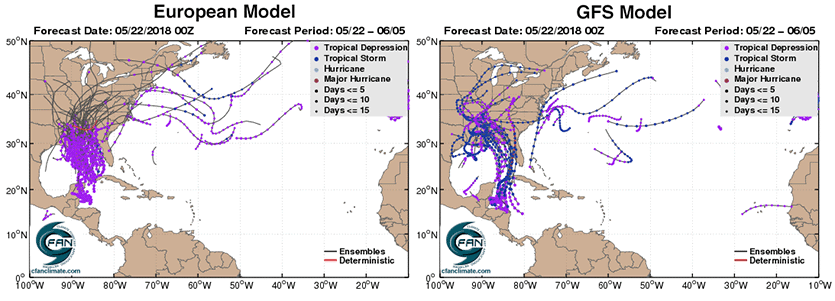
| Figure 1. Predicted tracks of a potential tropical depression or tropical storm from the 0Z Tuesday European model ensemble forecast (left) and 0Z Tuesday GFS ensemble forecast (right). About 40% of the ensemble members of both models predicted that a tropical depression would form by early next week. The purple dots show where the predicted storm is at tropical depression strength, and the blue dots, tropical storm strength. None of the ensemble members predicted that a hurricane-strength storm (light blue dots) would form. Image credit: cfanclimate.com. |
Model predictions still fuzzy
The 0Z Tuesday operational runs of our top three models for predicting tropical cyclone genesis--the European, GFS and UKMET models--all showed some weak development of 90L, but differed in the timing and location of development. The European model predicted that a tropical depression would form by Saturday in the waters a few hundred miles south of Mississippi. The 0Z and 6Z Tuesday operational runs of the GFS model kept wind shear higher, and had a weak system, possibly at tropical depression strength, making landfall along the west coast of Florida on Sunday. The 0Z Tuesday run of the UKMET model predicted that development of a tropical depression would occur in the western Caribbean on Sunday, with the system tracking northwards a few hundred miles west of the west coast of Florida on Monday.
About 40% of the 70 ensemble members of the European and GFS models predicted that a tropical depression would form over the eastern Gulf of Mexico by early next week. These solutions predominantly predicted a track that would result in landfall between Louisiana and the Florida Panhandle between Saturday and Monday. None of the ensemble members of the 0Z Tuesday European or GFS models predicted that a hurricane-strength storm would occur.
 |
| Figure 2. Predicted precipitation for the 7-day period ending at 8 am EDT Tuesday, May 29, 2018. Invest 90L is predicted to bring rainfall amounts of 3 - 5 inches to much of the Southeast U.S. Image credit: National Weather Service. |
Heavy rains the main threat
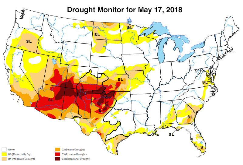
Regardless of development, the counter-clockwise flow of air around this low-pressure system in combination with a very wet tropical airmass will funnel large amounts of tropical moisture over Cuba and the Southeast U.S., resulting in very heavy rains during the coming week. The latest guidance from the National Weather Service (Figure 2) shows that 3 – 5” of rain is expected over the next 7 days over much of the Southeast U.S. Much of the Southeast U.S. is abnormally dry or in moderate drought, though, which will make the region less prone to flooding than usual for this time of year.
 |
| Figure 3. The drought monitor map for May 17, 2018, showed that portions of the Gulf Coast and Southeast U.S. were abnormally dry or in drought, which will make the region less prone to flooding than usual for this time of year. Image credit: droughtmonitor.unl.edu. |


