| Above: Icicles hang from a porch on Ocean Street as cleanup takes place in the Brant Rock section of Marshfield, MA, following a winter storm that flooded much of the area the previous day, on Jan. 5, 2018. Image credit: John Tlumacki/The Boston Globe via Getty Images. |
A fresh blast of Arctic air was making its way toward the eastern U.S. on Tuesday, accompanied by yet another round of snow and ice deep into the South, from Austin to Atlanta. It’s already been a memorable winter for the nation’s eastern half, with the coldest or second-coldest week between Christmas and New Year’s on record at a number of spots. What’s less obvious is that the persistent bouts of frigid air have been surrounded—and in some cases interrupted—by pockets of record-breaking warmth for January.
Record mildness in midwinter doesn’t grab the headlines as aggressively as record cold, since the effects are more often tranquil than terrible. But even a balmy stretch in January can have its problematic side, especially if it follows a deep freeze. Over the past few days, colossal ice jams have gummed up rivers and triggered evacuations over parts of the northeast U.S. and southeast Canada. A local state of emergency was declared Monday for the town of Kent, Connecticut, which is at risk from an ice jam reported to be a mile long and 12 feet deep on the Housatonic River, as reported by weather.com. Damage to a dock caused by ice jams on the St. Clair River northeast of Detroit is impeding cross-border traffic between the U.S. and Canada, according to the Associated Press, and a mobile home park in Plattsburgh, NY, was evacuated over the weekend, with several homes still cut off by floodwater. A Facebook post by Gilles Poirier shows a spectacular ice jam along the Shediac River in New Brunswick, Canada, on Saturday.
Ice jams develop when a rapid warm-up triggers sudden fragmentation of the ice atop a frozen river. Huge chunks of ice can pile up downstream, especially where the ice has yet to give way.
Ice jam on the Ausable River in Au Sable Forks NY. Video starts at noon (17:00Z) and ends at 3pm (20:00Z). They happen fast! #icejam #nywx pic.twitter.com/vO5HJQeCcU
— NWS Burlington (@NWSBurlington) January 12, 2018
Weather whiplash, 2018 style
Conditions last week were tailor-made for ice-jam formation. After close to three weeks of bitter cold, readings soared well above 50°F late last week. North of Maine, the Canadian province of New Brunswick set its all-time January high with a reading of 17.3°C (63.1°F) at Sussex Four Corners on Saturday. Temperatures got as high as 19°C (66.2°F) in Nova Scotia, breaking all-time January highs at several communities, including Halifax with 15.4°C (59.7°F).
Some of the ups and downs in the northeast U.S. have been head-spinning. In Burlington, VT, a daily record low of –20°F on Jan. 7 was followed by a record high of 61°F on Fri., Jan. 11. By Sunday morning, Jan. 13, temperatures were back down to –5°F. Just as impressive, given how cold it's been: Albany, NY, has failed to set even one record low all winter—but it did manage to score a daily record high on Friday, with 63°F.
 |
| Figure 1. Departures from average temperature for the period Jan. 1-14, 2018, with the U.S. divided between a colder-than-average East and a warmer-than-average West. Image credit: NOAA/NWS Weather Prediction Center. |
The delivery vehicle for the past month’s cold air has been a persistent ridge/trough pattern across North America, with the jet stream arcing far north into Alaska and western Canada and then diving back southward through the center of the continent. Underneath the Western ridge, it’s been a whole other country, meteorologically speaking. Both Los Angeles and San Francisco (airport sites) have been warmer than average every day since Christmas. Salt Lake City is running a full 9°F above average for January thus far.
On the west side of the ridge, mild, moist Pacific air has been periodically streaming all the way to Alaska. The enhanced moisture helped trigger immense snows at Thompson Pass, AK, last month (see the related post by WU weather historian Christopher Burt).
Over the weekend, a new surge of mild Pacific air sent temperatures at a number of sites in southeast Alaska well above the state’s January record high of 62°F. All-time local records for January set on Sunday included 66°F at Annette, 65°F at Craig, 64°F at Klawock, and 63°F at Sitka.
For the month thus far, record lows are still outnumbering record highs for the nation as a whole. As of Fri. 1/11, January had notched a preliminary total of 2848 record daily lows and 1747 daily record highs, according to NOAA/NCEI. Yet another crop of daily record lows may emerge this week with the latest shot of frigid air, which is expected to push temperatures below 10°F all the way to the northern fringes of Texas and Mississippi. Some locations from Texas to Florida will experience their second or even third round of frozen precipitation this winter.
 |
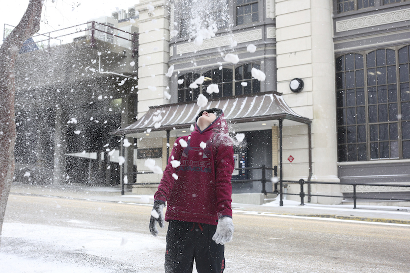
| Figure 2. Brayden Nevels, 12, plays with snow on Clay Street in downtown Vicksburg, Miss., on Tuesday, Jan. 16, 2018. Ice had coated roads and bridges in 36 of Mississippi's 82 counties, mostly in the northern and central parts of the state, the Mississippi Department of Transportation said in a statement Tuesday morning. Some of the heaviest snow in Mississippi was expected in the state's Delta region, where up to 3” was possible. Image credit: Courtland Wells/The Vicksburg Post, via AP. |
A pattern change ahead—but how much of one?
Rain and mountain snow totals continue to be well below average across most of the U.S. West, especially in the Four Corners states, which are now virtually covered by at least moderate drought. Some areas will get their thirst at least partially slaked over the next week, as the highly amplified pattern relaxes somewhat and several moderately strong Pacific storms move through the West.
It wouldn’t be too shocking if the western and eastern U.S. were to trade places later this winter. A weak but distinct La Niña continues to hold sway across the tropical Pacific Ocean. As we discussed back in November, colder-than-usual weather associated with La Niña tends to migrate from the Northeast toward the Northwest U.S. as winter unfolds, while warmer-than-usual weather becomes more likely across the southeastern half of the country. We’ll see if next week’s trial-balloon pattern change turns out to herald something more substantial and long-lived.
 |
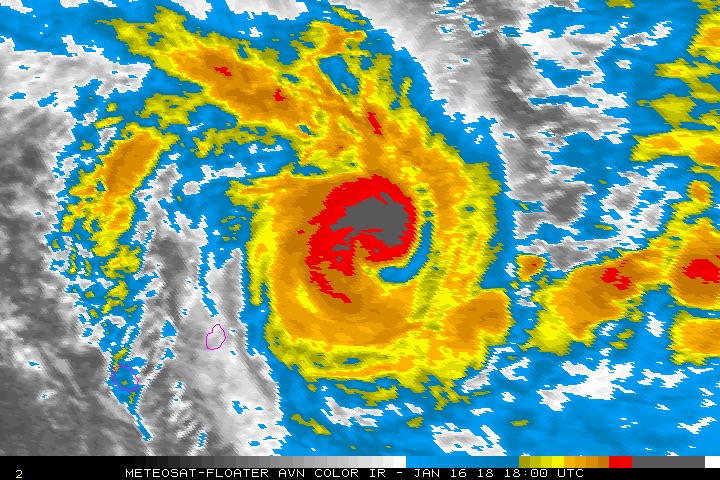
| Figure 3. Tropical Cyclone Berguitta as of 1800Z Tuesday, January 16, 2018. Image credit: Meteosat, via NOAA/NESDIS. |
Berguitta peaks at Category 3 strength in Southwest Indian Ocean
Tropical Cyclone Berguitta surged to minimal Category 3 strength (top sustained winds of 115 mph) late Monday as it headed toward Mauritius and La Réunion Island. Thanks to its steep topography, La Réunion is legendary for some of the heaviest rainfall ever observed on the planet, including the world-record 24-hour total of 1825 mm (71.8”) observed on Jan. 7-8, 1966.
As of 21Z Tuesday, Berguitta's top winds had dropped to 90 mph, making it a Category 1 storm. Berguitta was predicted by the Joint Typhoon Warning Center to be a slowly weakening Category 1 storm as it chugs across or near the two islands from late Wednesday into early Thursday, with dry air infiltrating its circulation. Berguitta will be passing over sea surface temperatures of 27–28°C (81-82°F), more than adequate to support a hurricane-strength storm, and wind shear is expected to remain in the moderate 10-20 knot range up till landfall. Several models show Berguitta maintaining or regaining strength as it makes a direct hit on Mauritius, including the 12Z Tuesday run of the HWRF. According to the nation’s weather service, the last tropical cyclone to make a direct landfall on Mauritius was Christelle (1995), a tropical depression at the time. A year earlier, Cyclone Hollanda (1994) passed less than 20 miles to the northwest of Mauritius as a Category 2 storm, damaging hundreds of homes. Wind impacts will be minimized if Berguitta passes to the southeast of La Réunion, as predicted, which would put that island in the weaker northwest quadrant of the storm.
Despite some lurid, clickbait-y headlines you may encounter on the Web, Berguitta is not expected to “destroy” either Mauritius or La Réunion. Heavy rains and high winds are a safe bet, though, and flooding and landslides could pose a significant threat. ReliefWeb notes that Berguitta will arrive on the heels of Tropical Cyclone Ava, which dropped more than 15” of rain on parts of La Réunion earlier this month.
Berguitta is expected to remain well east of Madagascar as it recurves toward the south and east late this week.


