Above: The remains of Harvey as seen by the GOES-16 satellite at 9:15 am EDT Tuesday, August 22, 2017. Image credit: NOAA/CIRA/RAMMB. NOAA’s GOES-16 satellite has not been declared operational and its data are preliminary and undergoing testing.
All eyes are on the hurricane-friendly waters of the Gulf of Mexico’s Bay of Campeche, where the remains of Tropical Storm Harvey are expected to organize into a tropical storm or hurricane that will threaten Texas and Mexico late this week.
On Friday, Harvey buffeted the Windward Islands as minimal tropical storm with 40 mph winds. High wind shear near 20 mph, combined with the accelerating east-to-west blowing trade winds that Harvey was embedded in, were sufficient to rip the storm apart on Saturday in the Eastern Caribbean, and the remains of Harvey were unable to reorganize over the Western Caribbean.
Satellite images on Tuesday morning showed that center of ex-Harvey was just about to emerge from the western edge of Mexico’s Yucatan Peninsula into the Gulf of Mexico. Ex-Harvey had a large, sloppy-looking circulation that was not well-defined, and only a modest amount of heavy thunderstorm activity. Once the storm fully emerges over the Gulf, conditions are quite favorable for development. Wind shear is light, less than 10 knots. The atmosphere has a high mid-level relative humidity of 70%, and the ocean is warm, with sea surface temperatures (SSTs) of 29°C (84°F.)
 |
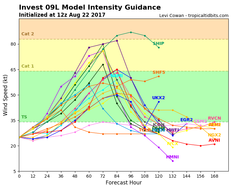
| Figure 1. Intensity forecasts made for ex-Harvey at 8 am EDT Tuesday, August 22, 2017. Most of the intensity models predicted ex-Harvey would be a strong tropical storm or Category 1 hurricane by Friday, when landfall is expected on the coast of Texas or northeastern Mexico. Image credit: Levi Cowan, tropicaltidbits.com. |
Forecast for ex-Harvey
SSTs will increase to 30°C (86°F) as ex-Harvey moves to the northwest towards Texas this week. The wind shear will stay light, and the atmosphere will remain moist. These conditions should allow ex-Harvey to regenerate into at least a tropical storm before it makes landfall on Friday, and it may be able to reach hurricane strength. The 0Z Tuesday operational runs of our three reliable global models for predicting tropical cyclone genesis—the GFS, European and UKMET models—all developed the system into a tropical storm or hurricane, and all of these models showed a landfall between the Mexico/Texas border and the central coast of Texas on Friday. The NOAA jet is flying a dropsonde mission over the Gulf of Mexico on Tuesday evening to help the models make good forecasts for their 0Z Wednesday runs. In its tropical weather outlook issued at 8 am EDT Tuesday, the National Hurricane Center gave ex-Harvey 2-day and 5-day odds of development of 70% and 90%, respectively. Regardless of development, coastal Texas can expect heavy rains in excess of five inches late this week.
92L disorganized over The Bahamas
Tropical disturbance 92L was located near the northwestern Bahamas on Tuesday morning. Satellite images on Tuesday morning showed that 92L had almost no heavy thunderstorm activity and very little organization. The system may have better chances of development this weekend, when it is expected to be moving to the northeast, away from the U.S. coast. In its tropical weather outlook issued at 8 am EDT Tuesday, the National Hurricane Center gave 92L 2-day and 5-day odds of development of 10% and 30%, respectively.


