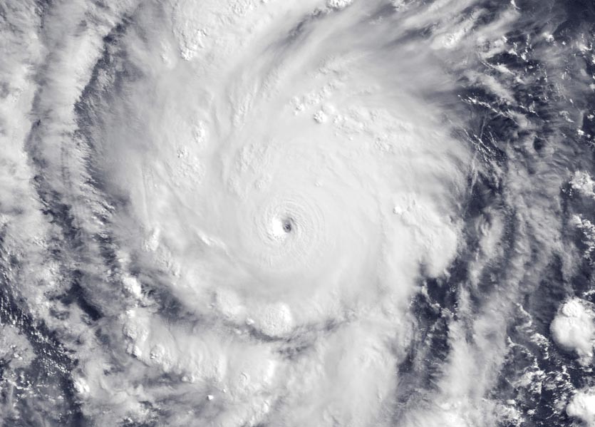
| Above: Hurricane Aletta (left) and Invest 92E (right) as seen at 11:45 am EDT June 8, 2018. Image credit: NOAA/RAMMB. |
The Western Hemisphere’s first major hurricane of 2018 is the Eastern Pacific’s Hurricane Aletta. Aletta put on a remarkable display of rapid intensification overnight Thursday, with the winds increasing by 70 mph in just 24 hours. Aletta was merely a tropical storm with 70 mph winds at 11 am EDT Thursday, but by Friday at 11 am, the hurricane had morphed into a fierce Category 4 storm with 140 mph winds. This rapid intensification episode was not well-forecast; the official NHC intensity forecast made at 11 am EDT Thursday called for Aletta to peak with 100 mph winds. The only other major tropical cyclones in the Northern Hemisphere thus far in 2018 have been the Western Pacific’s Typhoon Jelawat, which topped out as a Category 4 storm with 150 mph winds on March 30, and Tropical Cyclone Mekunu, which topped out as a Category 3 storm with 115 mph winds when it made landfall in Oman on May 25.
Though sea surface temperatures (SSTs) were marginal for further intensification of Aletta on Friday afternoon (27.5°C or 81°F), light wind shear and a moist atmosphere make it possible for Aletta to intensify more. Given the relatively cool SSTs, the storm is likely to fall short of Category 5 status. Fortunately, Aletta is located well south of the coast of Mexico, and will not cause any direct impacts to land areas, other than bringing high surf. The west-northwest motion of the hurricane will carry it into a region with cooler SSTs and higher wind shear over the weekend, with the storm likely dissipating by Tuesday.
#GOESEast captured the eye of #HurricaneAletta this morning currently a category 4 #hurricane with maximum sustained winds of 140 mph. Follow the storm: https://t.co/P1F11zXUHI #Aletta pic.twitter.com/hDpA4NTNr4
— NOAA Satellites (@NOAASatellites) June 8, 2018
An unusually early appearance for the Eastern Pacific’s first major hurricane
Aletta became a tropical storm on June 6, not far from the climatological June 10 appearance of the Eastern Pacific’s first named storm. However, Aletta became a hurricane on June 7, well before the usual June 26 appearance of the basin’s first hurricane, and Aletta attained major hurricane status on June 8, nearly six weeks before the usual July 19 appearance of the first major hurricane of the season. Aletta’s early appearance as a Category 4 hurricane was made possible by SSTs that were over 1°C (1.8°F) above average.
Aletta ranks as the 6th earliest Category 4 Eastern Pacific hurricane on record, according to the NOAA historical hurricane tracks website:
- May 25 – 26, 2014: Amanda (155 mph)
- May 28 – 29, 2001: Adolph (145 mph)
- June 1, 2015: Andres (145 mph)
- June 6, 2015: Blanca (130 mph)
- June 6 – 8, 1973: Ava (160 mph)
- June 8, 2018: Aletta (140 mph)
NOAA's 2018 Eastern Pacific Hurricane Season outlook, issued May 24, calls for an 80% chance of a near-normal or above-normal season. An above-normal season is most likely (45% chance), followed by a 35% chance of a near-normal season and a 20% chance of a below-normal season.
 |
Figure 1. Hurricane Amanda, the strongest May hurricane on record in the East Pacific, on May 25, 2014. Image credit: Navy Research Lab, Monterey. |
Heads up, Baja: 92E/Bud likely headed your way
Satellite imagery on Friday morning showed that a concentrated area of heavy thunderstorms in association with a broad area of low pressure located a few hundred miles southwest of the Mexico/Guatemala border (92E), did not yet have much spin, but the thunderstorms were gradually becoming more organized and were increasing in intensity and aerial coverage. Conditions were favorable for development, with the 12Z Friday run of the SHIPS model predicting mostly moderate wind shear of 10 – 20 knots through Saturday morning, a very moist atmosphere, and very warm sea surface temperatures (SSTs) near 31°C (88°F)--about 1°F above average. Our top models for predicting tropical cyclone genesis all forecast 92E to become Tropical Storm Bud by Monday. In their 8 am EDT Friday Tropical Weather Outlook, the National Hurricane Center (NHC) gave 92E 2-day and 5-day odds of development of 80% and 90%, respectively. The models predict that 92E/Bud could be a threat to Mexico’s Baja Peninsula by Friday, June 15.
When will Beryl come in the Atlantic?
The next name on the Atlantic list of storms for 2018 is Beryl, but Friday morning’s 5-Day Tropical Weather Outlook from NHC highlighted no areas of concern for the next five days. The 0Z Friday runs of our top three models for forecasting tropical cyclone genesis—the European, UKMET and GFS models—had one of them, the GFS model, call for development of a tropical depression in the coming week. The GFS model has been predicting in recent runs what may be a Central American Gyre (CAG)--similar to the one that spawned Subtropical Storm Alberto--to form over Central America, and potentially spawn a tropical depression in the Western Caribbean or Gulf of Mexico sometime in the June 13 – 17 period. About 40% of the 20 members of the 0Z Friday GFS model ensemble went along with this idea, as did the 6Z and 12Z Friday runs of the operational GFS model. Back in mid-May, the GFS model did correctly forecast the genesis of Alberto from a CAG seven days in advance, but only after issuing about a week’s worth of false alarm forecasts. So, until the European and/or UKMET model echo the GFS forecast, we should not pay undue attention to its long-range musings about Beryl forming in the coming week. Philippe Papin has an excellent series of tweets discussing Central American Gyres.
Have a great weekend, everyone!


