| Above: A tropical wave located a few hundred miles south of the Cabo Verde Islands at 11 am EDT Wednesday, July 26, 2017. Image credit: NOAA. |
A tropical wave located at 11 am EDT Wednesday near 11°N, 25°W, about 200 miles south of the Cabo Verde Islands, was headed west at 10 - 15 mph, and has marginal potential to develop into a tropical depression early next week.
Satellite images on Wednesday morning showed that the wave was embedded in the Intertropical Convergence Zone (ITCZ), a semi-permanent band of heavy thunderstorms that extends across the tropics. The wave had a little spin and only a modest amount of heavy thunderstorm activity. The dry air of the Saharan Air Layer (SAL) was well to the north of the disturbance, and was likely not slowing development much. Wind shear was low to moderate, 5 – 15 knots, which was favorable for development. Sea Surface Temperatures (SSTs) were just warm enough for development, near 27°C (81°F)--about 1°F above average.
Forecast
The wave may struggle to separate itself from the ITCZ over the next few days, and the presence of dry air to the system’s north, marginally warm SSTs, and the relatively low latitude of the system may also act to slow development. Also, the Madden-Julian Oscillation (MJO), a periodic pulse of thunderstorm activity that circles equatorial regions of the globe every few weeks, is in a phase that will tend to suppress development of Atlantic and Eastern Pacific tropical cyclones this week.
The operational versions of our three top models for predicting tropical cyclone genesis--the European, GFS and UKMET—did not show development of the system over the next five days in their 0Z Wednesday runs, except for the UKMET model, which suggested some weak development followed by dissipation early next week. The 20 members of the 0Z Wednesday GFS ensemble forecast and 50 members of the European model ensemble forecast had fewer than 30% of their members predict development over the next five days, and nearly all of these forecasts showed the storm dying out before reaching the Caribbean. In their 8 am EDT Wednesday Tropical Weather Outlook, the National Hurricane Center (NHC) gave the system 2-day and 5-day odds of tropical cyclone development of 0% and 20%, respectively.
A new tropical wave predicted to emerge from the coast of Africa this weekend may end up having better odds of development next week.
 |
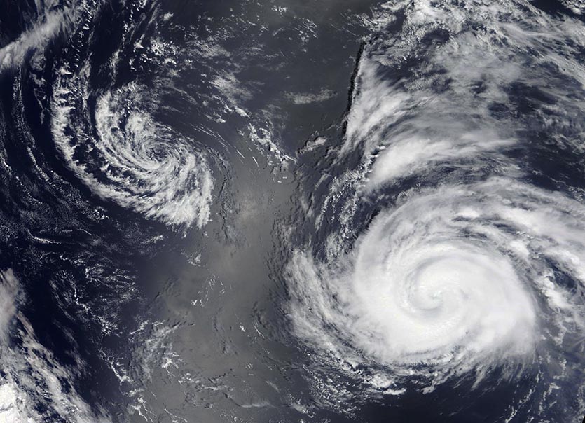
| Figure 1. MODIS satellite image of Typhoon Noru (right) and Tropical Depression Kulap (left) in the remote Northwest Pacific on Tuesday afternoon, July 25, 2017. Image credit: NASA. |
Meandering Noru is the Northwest Pacific’s first typhoon of 2017
It’s been an exceptionally slow start to the Northwest Pacific typhoon season, with Sunday’s formation of the season’s first typhoon, Noru, marking the second-latest appearance on record for the season’s first hurricane-strength storm. The only other year on record that took so long to produce a typhoon was 1998, whose first typhoon, Otto, did not form until August 3, according to Phil Klotzbach. However, the Northwest Pacific is now very active, thanks to a favorable phase of the Madden-Julian Oscillation (MJO), plus the formation of the “Monsoon Trough”—a large area of low pressure that forms each summer in the Northwest Pacific, in association with the summer monsoon. This year’s monsoon trough has set up much farther to the north than usual, resulting in formation of tropical storms at a higher latitude than usual.
The long-range fate of Noru is uncertain, but the storm could pose a threat to Japan over a week into the future. Early this week, Noru and Tropical Storm Kulap did a Fujiwhara interaction, the process by which two tropical cyclones close to each other take on an aspect of rotation around a point in between. Noru’s upper-level outflow killed off Kulap on Tuesday evening, and Noru is expected to meander well to the southeast of Japan for at least another week.
Meteorologist Boris A. Konon pointed out to me that in the past six days since it formed, Typhoon Noru has completed a loop southeast of Japan, and looks like it will have the distinction of not only double looping over its track, but also crossing over its track multiple times. How atypical is this? It happens more often than one would think, given the plethora of tropical cyclones that form in the Northwest Pacific—an average of 26 named storms each year.
Taiwan may get 2017’s first landfalling typhoon
Tropical Storm Nesat formed in the waters about 500 miles east of the Philippines on Tuesday, and may become the season’s first landfalling typhoon this weekend in Taiwan. Nesat is over waters very favorable for development, with SSTs near 31°C (88°F), but is contending with moderate wind shear of 10 – 20 knots. These conditions should allow Nesat to slowly intensify from its 50 mph winds on Wednesday morning to Category 1 typhoon strength by Thursday, as the storm heads northwest towards Taiwan. By Friday, strong upper-level winds out of the northeast may create high enough wind shear to begin weakening Nesat, and the Joint Typhoon Warning Center is predicting that Nesat will make landfall this weekend in Taiwan at Category 1 strength.
 |
| Figure 2. VIIRS satellite image of Hurricane Irwin (left) and Hurricane Hilary (right) in the Eastern Pacific at 5:54 pm EDT Tuesday, July 25, 2017. Image credit: NASA, |
Hilary and Irwin in the Northeast Pacific no threat to land
In the Northeast Pacific, we have Tropical Storm Irwin and Hurricane Hilary, which are projected to stay well out to sea over the next five days. Hilary is an impressive-looking Category 2 storm with 105 mph winds, but is expected to encounter drier, more stable air on Thursday, and begin weakening. A south swell generated by Hurricane Hilary will bring high surf Friday through Tuesday to Southern California, with peak surf of 5 - 7 feet, with sets to 10 feet, on Sunday and Monday along south-facing beaches.


