
Above: Rudy Horvath hands a piece of wood up to his wife Dawn Horvath, as their home, a boathouse in the West End section of New Orleans, takes on water a from storm surge in Lake Pontchartrain in advance of Tropical Storm Cristobal on Sunday, June 7, 2020. (AP Photo/Gerald Herbert)
Tropical Depression Cristobal was working its way northward through Arkansas on Monday afternoon, gradually spinning down while still dumping noteworthy rainfall. The storm dropped 5” to 10” of rain across southeast Louisiana, far southern Mississippi and Alabama, and northern Florida. Some 24-hour totals from CoCoRaHS volunteers through Monday morning included 9.17” near Mandeville, LA; 7.10” northwest of Pass Christian, MS; 6.45” near Mobile, AL; and 7.17” at White Springs, FL.
Thus far, Cristobal’s damage has been relatively modest. Winds at landfall were not extreme, and the rains have fallen largely atop ground that was drier-than-average. The highest-impact storm surge was limited to far southeast Louisiana on Sunday, and waters remained high in some areas on Monday. According to weather.com, 29 people were rescued from cabins on stilts that were surrounded by persistent high water at Fontainebleu State Park near Mandeville, on the north side of Lake Pontchartrain. Widespread flooding was also reported in low-lying Grande Isle, LA.
In Florida, tornadoes were confirmed in Cristobal’s rainbands on Saturday near Orlando and on Sunday south of Lake City. The NOAA/NWS Storm Prediction Center database showed 15 preliminary tornado reports related to Cristobal for Saturday and Sunday, all of them in Florida.
Will Cristobal become the Atlantic’s first post-tropical cyclone to reach the heart of Wisconsin?
Flooding will remain a concern as Cristobal and its slug of exceptionally rich moisture accelerate northward. Fortunately, the system’s quickening pace will help reduce the higher-end possibilities. Flash flood watches extended from Louisiana to Wisconsin as of Monday afternoon. In its Day 2 outlook for Tuesday, the NWS/NOAA Weather Prediction Center had an expansive slight-risk area for excessive rain leading to potential flash flooding, stretching from eastern Nebraska to Upper Michigan.
Cristobal is being pulled northward ahead of a strong midlatitude cyclone pushing across the Northern Plains. Tropical cyclones and their remnants typically recurve well before they get to the Upper Midwest as identifiable centers, but NHC is predicting that Cristobal will move across the length of Wisconsin as a post-tropical cyclone on Tuesday night. It may actually reintensify slightly as it comes under the influence of the approaching upper-level storm system and heads into Ontario.
Only three systems from the Atlantic have been known to reach Wisconsin as identifiable post-tropical cyclones. Two of them were catastrophic events during their respective landfalls: the Galveston hurricane of 1900 and Hurricane Gilbert of 1988. As shown below, all three of these hurricanes only managed to nick the southeastern corner of Wisconsin as post-tropical cyclones, so Cristobal will certainly carve a path in state history if it transects the state, even if its sustained winds are only in the 25-35 mph range.
The 12Z Monday run of the GFS model predicted that precipitable water (the amount of moisture in an imaginary column above the surface) could set a June record over Milwaukee on Tuesday night as Cristobal passes by, with values possibly topping 2.20”. (We should note that hurricanes from the Northeast Pacific often contribute into high-impact rainstorms across the Southern Plains, and sometimes their moisture makes it all the way to the Midwest.)
Cristobal’s place in climatology
Cristobal was the earliest “C” storm in any year of Atlantic hurricane records going back to 1851, and the second tropical storm to make landfall in the U.S. this year, following marginal Tropical Storm Bertha. Cristobal was also the second earliest tropical storm or hurricane landfall in Louisiana on record. No other year before 2020 has seen two tropical-cyclone landfalls confirmed on U.S. shores by June 7, according to Phil Klotzbach (Colorado State University). However, he is not confident that Cristobal would have been classified as a tropical system at landfall prior to the satellite era.
Klotzbach also points out that records prior to 1900 may not include some tropical storm landfalls because smaller populations along the Gulf and southeast Atlantic coasts. “While we probably didn't miss hurricanes, we certainly could have missed weaker tropical storms,” said Klotzbach in an email.
More than 20 forecast groups have concluded that we’re likely to have a busier-than-average hurricane season (see the end of our post from last Thursday), based on variables such as already-warm sea surface temperatures in the North Atlantic and the apparent shift in the tropical Pacific toward La Niña. However, it would be wrong to assume that we’re in for an active season simply because it’s gotten off to an unusually busy start, as pointed out by Klotzbach in the tweet below.
The latest U.S. derecho hits the Central Rockies and High Plains
The nation’s highest wind gusts in recent days didn't occur with Cristobal. Instead, they’ve been generated by multiple derechos—long-lasting corridors of downburst wind generated by intense thunderstorms. One derecho plowed from eastern Pennsylvania across New Jersey on Wednesday, June 3, causing three fatalities and knocking out power to more than half a million people. Wind gusted to 89 mph at Long Beach Island on the New Jersey coast.
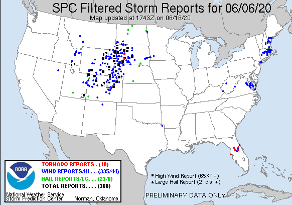
A more unusual derecho, geographically speaking, blasted from Utah across southern Wyoming and Colorado into western Nebraska, South Dakota, and North Dakota on Saturday. It was generated by an unusually strong, cold upper-level storm pushing in from the Pacific Northwest and encountering much hotter air near the surface. According to the Colorado Climate Center, “This may be the first legitimate "derecho" to impact Colorado—at least the first one since reliable records became available in the mid-20th century.”
As the intense squall line roared through Colorado, winds gusted at higher elevations to 110 mph near Winter Park and 90 mph just east of Copper Mountain. Gusts hit 78 mph at Denver International Airport as the derecho blew through. The storms prompted the two largest severe thunderstorm warnings (by far) issued by the NWS/Boulder office in records going back to 2007.
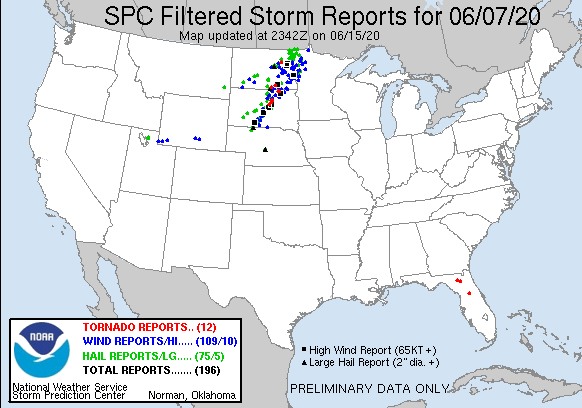
The derecho went on to spawn dramatic cloud formations across western South Dakota, as well as two brief tornadoes, confirmed by the NWS office in Rapid City. For more details and a jaw-dropping collection of photos, see the office's recap of the event.


