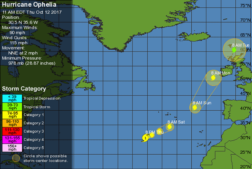
Above: WU tracking map for Hurricane Ophelia from the 11 am EDT Thursday, October 12, 2017 advisory from NHC. At 8 AM Monday, Ophelia is predicted to be a post-tropical (extratropical) storm approaching western Ireland with winds comparable to a Cat 1 hurricane.
Hurricane Ophelia continued 2017's long streak of Atlantic named storms that have developed into hurricanes, becoming 2017’s tenth consecutive hurricane at 5 pm Wednesday. Only three other years have seen ten consecutive Atlantic hurricanes: 1878, 1886, and 1893. (Note that within some of those late-1800s strings, there might have been small, short-lived tropical storms that today’s satellites would have caught.) Ophelia’s presence this week has brought 2017’s Accumulated Cyclone Energy (ACE) in the Atlantic above 211, making it the seventh most active season on record. This year is now tied for eighth place for most number of hurricanes (10), tied for fifteenth place for most number of named storms (15), and tied for ninth place for most major hurricanes (5). Ophelia will brush the southeastern Azores Islands on Saturday, and will likely bring tropical storm-force winds to Ireland as a powerful extratropical storm on Monday.
 |
| Figure 1. An uncommon sight: Hurricane Ophelia headed towards Europe at 9 am EDT Thursday, October 12, 2017. |
Satellite images on Thursday morning showed that Ophelia was located in the central Atlantic about 715 miles southwest of the Azores, and had a distinct eye surrounded by a modest area of heavy thunderstorms. Ophelia was moving little, and this slow motion will act to churn up cooler sub-surface waters, potentially weakening the hurricane. Otherwise, Ophelia had favorable conditions for intensification, with moderate wind shear near 10 knots, and sea surface temperatures (SSTs) just warm enough to support tropical development (around 26.5°C, or 80°F), coupled with unusually cold conditions for this time of year in the upper atmosphere. The result was enough atmospheric instability to support convection, but with weaker updrafts given the comparatively cool conditions at all altitudes.
 |
| Figure 2. Wind forecast from the 0Z Thursday run of the European model, valid at 17Z Monday, October 16, 2017. Sustained tropical storm-force winds of 40 mph were predicted along much of the southern coast of Ireland. |
Ophelia expected to affect the Azores and Ireland
The forecast for Ophelia is straightforward. Wind shear will remain in the 10 – 20 knot range through Friday, according to the 12Z Thursday run of the SHIPS model. Ophelia will become caught in the prevailing westerlies this weekend, which will accelerate the storm to the east-northeast and then northeast. Sea surface temperatures will gradually drop along Ophelia’s path, though they will remain near or above 26°C (79°F) until Friday afternoon. Even these marginally warm SSTs are about 1°C above average for mid-October. With the overall environment holding fairly constant, Ophelia should be able to maintain Category 1 strength until Monday, at which point it’s expected to transition into a powerful post-tropical (mid-latitude) storm with winds near hurricane strength.
#Ophelia pic.twitter.com/hKVzyl7qnE
— Jim Cantore (@JimCantore) October 12, 2017
On Ophelia's expected course, the storm will track near or just south of Santa Maria, the southernmost island of the Azores, on Saturday. The 6Z Thursday run of the GFS model brings Ophelia within about 60 miles of Santa Maria. Assuming that the island remains on the weaker left-hand side of Ophelia, wind impacts would be lessened, but torrential rains and squalls are still possible if Ophelia passes close enough. In NOAA’s historical hurricane database, which extends back to 1851, only 11 hurricanes have passed within about 200 miles of the Azores (as noted by weather.com). Every one of those occurred in August or September—except for strikingly unseasonal Hurricane Alex, which struck the islands in January 2016 just after weakening to tropical-storm strength.
Our top global track models continue to predict that a developing non-tropical low pressure system and its associated cold front will bring light rain to Ireland on Sunday, before the extratropical version of Ophelia spreads heavier rains of up to an inch on Monday. Sustained tropical storm-force winds of at least 40 mph with higher gusts are likely along portions of the southern and western coasts of Ireland on Monday.
| Figure 3. WU tracking map for Hurricane Debbie (1961). |
The case of Debbie
There is a rough analog for Ophelia’s potential to affect Ireland. “Of all the Irish windstorms in living memory, Debbie in September 1961 set many records that still stand to this day,” notes Irish Weather Online.
A Cape Verde-type storm that topped out at Category 3 strength, Hurricane Debbie tracked through the western Azores as a Category 1 hurricane, then arced northeast and brushed the west coast of Ireland, apparently not long after having transitioned from tropical to post-tropical (extratropical) cyclone. Debbie passed close enough to Ireland to produce major destruction. Wind gusts topped 100 mph at a number of stations, setting numerous all-time record high speeds. The Shannon airport notched 10-minute sustained winds of 69 mph and gusts as high as 107 mph; at Malin Head, winds were sustained for six hours at or above 62 mph. A surface pressure reading of 961.4 mb was reported at Belmullet, on Ireland’s west coast. Some parts of western Ireland lost nearly 25% of all trees. All told, Debbie took 18 lives in Ireland, plus 60 others from a Debbie-related plane crash in the Azores. Damage in Ireland totaled more than $40 million in damage (USD, 1961 value). Fortunately, Ophelia is not likely to be nearly as damaging as Debbie. The Irish weather service has issued a Yellow Alert for ex-Ophelia's impact.
We’ll have a post later today discussing the nomination of Barry Meyers, CEO of AccuWeather, to be the next head of NOAA.
Bob Henson co-wrote this post.


