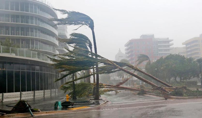
| Above: Recently planted palm trees lie across a road in Miami Beach, FL, on Sunday, September 10, 2017. Image credit: Wilfredo Lee/AP. |
Hurricane Irma made landfall at 9:10 am EDT Sunday on Cudjoe Key in the Lower Florida Keys, about 30 miles east of Key West, while classified as a Category 4 storm with 130 mph winds. Irma brought sustained winds near hurricane-force to the entire Florida Keys late Sunday morning, and a storm surge in excess of 3 feet to Key West and Miami. Irma was headed north at 9 mph along the west coast of Florida on Sunday afternoon, and will be bringing destructive winds and an extremely dangerous storm surge along its path.
 |
| Figure 1. Radar image of Hurricane Irma taken at the time of landfall in the Florida Keys, 9:10 am EDT September 10, 2017. Note the eyewall on the south side, but very intense echoes on the north side. |
Recent observations
The highest wind gust reported from Irma thus far was 120 mph at Key Deer National Wildlife Refuge on Big Pine Key, which took a hit from the strong right front portion of the eyewall between about 6:30 am and 8:30 am EDT. Although the site did not measure sustained winds higher than 55 mph in their hourly observations, they likely experienced much stronger sustained winds during passage of the eyewall, judging by a remarkable Facebook video posted by Brian Trible on Big Pine Key from 7 am EDT Sunday. He documented a storm tide of 5 – 7’. So far, the highest storm surge at NOAA tide gauges has been just over 3' at Key West and Miami. Here are the strongest sustained winds and wind gusts reported in the Florida Keys on Sunday morning:
55 mph gusting to 120 mph at 10:38 and 9:38 am, Key Deer NWR
68 mph gusting to 78 mph at 8 am, Pulaski Shoal Light
70 mph gusting to 89 mph at 8:24 am, Key West NOS
62 mph gusting to 94 mph at 9:42 am, Vaca Key
75 mph gusting to 92 mph at 9 am, Molasses Reef
52 mph gusting to 73 mph at 9:30 am and 9 am, Key Largo
The anemometer failed at Key West Airport at 7:27 am. Highest wind report before failure: 60 mph gusting to 94 mph at 7:15 am.
 |
| Figure 2. Close-up GOES-16 view of Irma’s eye at the time of landfall in the Florida Keys, 9:10 am EDT September 10, 2017. Image credit: NOAA/RAMMB. GOES-16 data is considered preliminary and non-operational. |
Irma is weakening
Irma has very likely reached its peak strength, and should weaken during the remainder of its life. An Air Force hurricane hunter aircraft did three center fixes in the storm on Sunday morning, and found that the pressure was steadily rising, increasing from 931 mb at 8 am EDT to 934 mb at 11 am EDT. Radar observations from the Key West radar Sunday morning showed that Irma had only a partial eyewall, with a big gap on the south side. The lack of a full eyewall and a rising pressure will make it difficult for Irma to intensify, particularly in the face of increasing wind shear. Wind shear had risen to the moderate range, 15 – 20 knots, late Sunday morning, and will rise further as Irma progresses northward. Interaction with land will also weaken Irma as it moves along the west coast of Florida. Unfortunately, Irma is a large storm and will have severe impacts on Florida. The Hurricane Hunters measured a very broad field of strong winds, with hurricane-force winds that extended out 80 miles to the east of the center, and tropical storm-force winds that extended out 220 miles. A hurricane with a wind field this broad should generate a much larger storm surge than a hurricane with a smaller more concentrated area of hurricane-force winds, like Hurricane Charley of 2004 had. The northern eyewall is very intense, which will help drive a large storm surge to the coast where the eyewall passes.
 |
| Figure 3. Power outage forecasts for Hurricane Irma from the Hurricane Power Outage model developed by Seth Guikema (University of Michigan), Steven Quiring (Ohio State University) and Brent McRoberts (Texas A & M Univeristy). These are experimental results, not a fully operational forecasting model. This model takes as input track and intensity forecasts from the National Hurricane Center and estimates the fraction of the population without power at the census tract level. This model is a statistical outage forecasting model based on wind speed estimates, population density, soil moisture levels, drought indices, and information about trees in each census tract. Image credit: Seth Guikema, U. of Michigan. |
Forecast for Irma
Irma is now firmly on its long-anticipated track toward the north and eventually north-northwest. Irma will track close to the west coast of Florida from late Sunday into Monday morning. Models agree that Irma will start hooking toward the northwest somewhere near the Florida Panhandle. This track will keep at least part of Irma’s circulation over water through Monday morning, but we can expect land interaction to take a steady toll on the hurricane. The latest NHC forecast predicts Irma to be a Cat 1 storm near Florida’s Big Bend by Monday morning and a decaying tropical storm in southern Georgia by Monday night.
If present trends hold up, Irma’s eye will make landfall somewhere close to Marco Island and move across Naples between 2 pm and 5 pm EDT, reaching Fort Myers several hours later. These are the most likely populated areas to experience Irma’s peak winds, though in a bit of good news, it appears the very strongest winds of Irma's eastern eyewall will affect the unpopulated Everglades. Irma is expected to produce several hours of sustained tropical-storm-force winds across almost all of Florida east of Tallahassee, extending into much of Georgia on Sunday night into Monday. Expect gusts of 60 - 100 mph to be widespread, especially during rainband squalls, as Irma’s large and intense upper-level wind field mixes to the surface. These winds can be strong enough to knock town trees and power lines, and widespread power outages are expected, especially through the western half of the Florida peninsula and well into Georgia (see Figure 3). High winds snapped a construction crane in Miami on Sunday morning.
Storm surge
The greatest area of concern for storm surge in populated areas remains the southwest Florida coast, especially from Cape Coral/Fort Myers to Naples, where inundation of 10 – 15 feet is possible. High tide is at 4:50 pm EDT in Naples Bay. Further north, inundation of 6 – 10 feet is possible south of Tampa, including Sarasota and Manatee Counties, and 5 – 8 feet in the Tampa/St. Petersburg area, including Tampa Bay. Easterly winds ahead of Irma can produce lower-than-usual water levels along Florida’s west and southwest coast before the core of the storm arrives: a negative surge of 4’ was observed at Naples late Sunday morning. In such cases, we can expect the surge to rapidly increase after the eye of Irma passes to the north, and southwest winds push water onshore. Inundations of 4 – 6 feet could occur north of the Tampa area to the southeast coast of the Florida Panhandle, as well as along the surge-prone coasts of Georgia and southern South Carolina. Because Irma's circulation is so large, strong onshore winds are bringing significant surge to Florida's southeast coast, including Biscayne Bay. Parts of downtown Miami were under several feet of water at midday Sunday (see embedded tweet below, from 11:40 am EDT).
Water still rising in downtown Miami along Brickell Avenue. Storm surge is intense. Neck deep in areas. @wsvn #HurrcaneIrma pic.twitter.com/RLhVWIkTzQ
— Brian Entin (@BrianEntin) September 10, 2017
 |
| Figure 4. Rainfall amounts predicted from Irma for the 3-day period from 8 am EDT Sunday, September 10, to Wednesday, September 13, 2017. Image credit: NOAA/NWS/WPC. |
Rain
Torrential rains of 5” – 15” will sweep across most of Florida from Sunday into Monday, with the heaviest amounts toward the western half of the peninsula. Very heavy rains (4” – 8”, with locally higher amounts) will push north across most of Georgia into parts of Alabama and South Carolina by Monday as Irma weakens. Rainbands sweeping into the Southern Appalachians could lead to localized flash flooding and mudslides along east-facing slopes and valleys. Rains from Irma could exacerbate flooding in coastal sections of GA and southern SC by Monday.
Tornadoes
Along with Irma’s myriad other threats, an outbreak of tornadoes is quite possible on Sunday. Irma’s unusual trajectory will help lead to enhanced wind shear in the forward right flank of the storm, a common locale for tornadoes in onshore hurricane rainbands. The 12:30 pm EDT Sunday outlook from the NOAA/NWS Storm Prediction Center put areas near the east-central coast of Florida in an enhanced risk of severe weather, and most of the peninsula in a slight risk, mainly for the tornado threat.
2017 the first year on record with two Cat 4+ U.S. Atlantic hurricane landfalls
The landfalls of Irma and Harvey as Cat 4s makes 2017 the first year on record (going back to 1851) with two Atlantic landfalling hurricanes of Category 4+ strength in the U.S. If we include Hawaii, 2017 is the second year for the U.S. as a whole to receive two Category 4+ hits, since in 1992 Category 5 Andrew hit Florida, and Category 4 Iniki hit Hawaii. According to Dr. Phil Klozbach, Irma’s landfall pressure of 929 mb is tied with the Lake Okeechobee Hurricane (1928) for 7th lowest pressure on record for a U.S. landfalling hurricane. As of 5 am EDT Sunday, Irma had now been a major hurricane for 8.25 days, making it the 2nd longest-lived Atlantic major hurricane since accurate satellite records began in 1966, trailing only Hurricane Ivan of 2004.
Bob Henson co-wrote this post.


