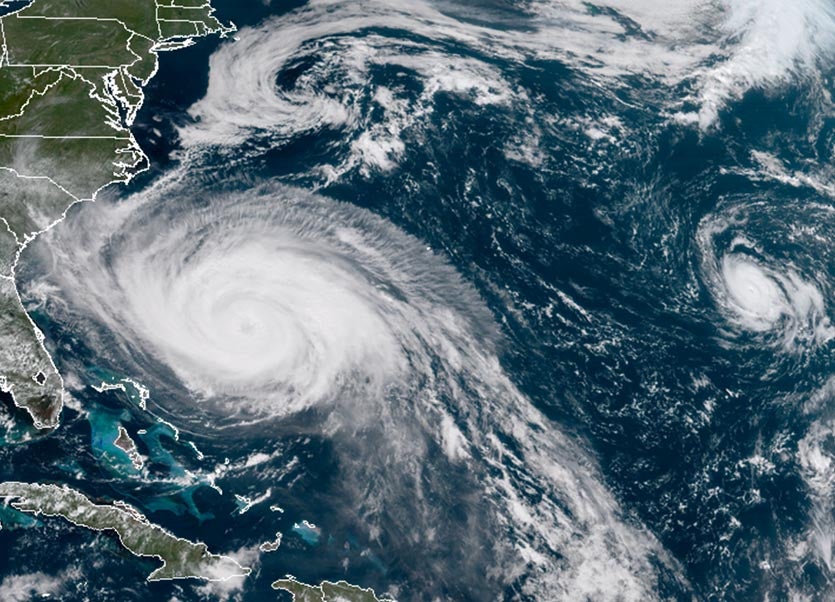
| Above: GOES-16 view of large Hurricane Maria (left) and small Hurricane Lee (right) at 12:45 pm EDT Sunday, September 24, 2017. The remains of Hurricane Jose can also be seen, just south of New England. Image credit: NOAA/RAMMB. GOES-16 imagery is considered preliminary and non-operational. |
Hurricane Maria was headed north at 9 mph on Sunday, shooting the gap between the Southeast U.S. coast to the west and the island of Bermuda to the east. Maria is expected to come within about 150 miles of North Carolina’s Outer Banks on Wednesday, then turn east-northeast, out to sea. Satellite imagery on Sunday afternoon showed that high cirrus clouds from Maria’s upper-level outflow were already streaming over South Carolina and North Carolina, but the heavy thunderstorms of the large hurricane remained well offshore. Maria had an impressive area of very intense thunderstorms surrounding a big 35-mile-diameter eye.
The Hurricane Hunters detected little change in Maria’s intensity on Sunday morning, with the pressure holding nearly steady at 947 - 948 mb, and the surface winds maintaining a Category 2 velocity, 105 - 110 mph. Maria was under light to moderate wind shear of 10 knots, due to upper-level winds out of the southwest. Sea surface temperatures were a warm 29.5°C (85°F).

| Figure 1. The 11 am Sunday NHC forecast for the probability of tropical-storm-force winds for the five days ending at 8 am Friday, September 29, 2017. The Outer Banks of North Carolina were given a 60 – 70% chance of tropical storm-force winds of 39+ mph, and the Norfolk, Virginia area was given a 30 – 40% chance. Image credit: NOAA/NWS/NHC. |
Intensity forecast for Maria
Maria will be moving into a region with cooler sea surface temperatures and a reduction in the total heat content of the ocean, and will continue to experience moderate wind shear. Our top intensity models predict a weakening trend as a result, with the storm being a tropical storm or Category 1 hurricane with 60 - 90 mph winds by Wednesday morning, when Maria will make its closest approach to North Carolina.
 |
| Figure 2. The 20 track forecasts for Maria from the 0Z Sunday, September 24, 2017 GFS model ensemble forecast; 10% of the solutions have a North Carolina landfall. Image credit: CFAN. |
 |
| Figure 3. The 50 track forecasts for Maria from the 0Z Sunday, September 24, 2017 European model ensemble forecast. The operational European model is the red line, adjusted by CFAN using a proprietary technique that accounts for storm movement since 0Z Sunday. The track of the average of the 50 members of the European model ensemble is the heavy black line. About 1/3 of the solutions show a North Carolina landfall. Image credit: CFAN. |
Track forecast for Maria
There hasn’t been a lot of change in the model track forecasts for Maria over the past day, with all of our top models predicting that the hurricane will make its closest approach to North Carolina on Wednesday, when the center is expected to come about 150 – 200 miles east of the Outer Banks. The 0Z Sunday runs of the GFS model and European model still had a number of ensemble members showing a landfall in North Carolina (Figures 2 and 3), so we cannot yet dismiss the possibility that Maria will make landfall. By Thursday, though, a trough of low pressure passing to the north of Maria will pull the storm rapidly east-northeastward out to sea.
Tropical storm-force winds are predicted to extend about 185 miles to the northwest of Maria’s center on Wednesday morning, so it is likely that the Outer Banks of North Carolina will experience sustained winds near 35 - 40 mph at that time. The counter-clockwise circulation of Maria will be capable of driving a storm surge of 2 - 4’ to the coast 50 miles on either side of Cape Hatteras. Heavy rains of 2 – 4” can also be expected along the Outer Banks on Wednesday.
 |
| Figure 4. MODIS visible satellite image of Hurricane Lee on Sunday morning, September 24, 2017. Image credit: NASA. |
Dinky Hurricane Lee not a threat to land
Hurricane Lee sprang back into life as a tropical storm on Friday night, emerging from the northern remnants of ex-Tropical Storm Lee. Lee 2.0 became a hurricane early Sunday morning, and appears poised to intensify into a major hurricane on Monday. Lee is a tiny storm, with hurricane-force winds that extend out 10 miles from the center, and tropical-storm-force winds that extend out 75 miles from its center. This small size gives it a greater potential to either intensify or weaken quickly. According to the 12Z Sunday analysis from the SHIPS model, Lee will have favorable conditions for development over the next two days, with wind shear a light 5 – 10 knots, and SSTs a warm 28°C (82°F)—about 1°C above average. The SHIPS model gave Lee a 22% chance of intensifying to a 120 mph Category 3 hurricane by Monday morning. By Tuesday, though, Lee will potentially encounter drier air with a mid-level relative humidity of 40%, and this dry air will likely interfere with intensification. Lee will remain far from land throughout the five-day forecast period, wandering through weak steering currents. Over time, Lee is expected to carry out a clockwise loop that will keep it in the central North Atlantic for the foreseeable future.
Lee is the eighth consecutive named storm in the Atlantic to reach hurricane strength, and brings this year’s tally so far to 13 named storms, 8 hurricanes, 4 intense hurricanes, and an Accumulated Cyclone Energy (ACE) of 179. A typical Atlantic season sees a total of 12 named storms, 6 hurricanes, 2 intense hurricanes, and an ACE of 92. We’re already in 12th place for most ACE on record for a season, and 6th place for major hurricane days (18.25), already beating out 2005.
 |
| Figure 5. Predicted precipitation for the 7-day period ending at 8 am Sunday, October 1, 2017. A moist flow of air associated with an upper-level low pressure system over the Western U.S., enhanced by moisture associated with the circulation of Tropical Storm Pilar, is expected to bring heavy rains to West Texas. Image credit: NOAA. |
Tropical Storm Pilar deluging Mexico, and will contribute to West Texas rains
In the Eastern Pacific, Tropical Storm Pilar formed on Saturday night, and is expected to bring heavy rains of 3 – 7” to the coast of Southwest Mexico near Puerto Vallarta. Pilar does not have long to live, as landfall on the coast a few hundred miles north of Puerto Vallarta is expected on Monday or Tuesday. A moist flow of air associated with an upper-level low pressure system over the Western U.S. will incorporate some of the moisture from Pilar and stream northwards into West Texas over the coming week. This moisture will interact with a slow-moving cold front to bring widespread heavy rains in excess of 5” to West Texas.


