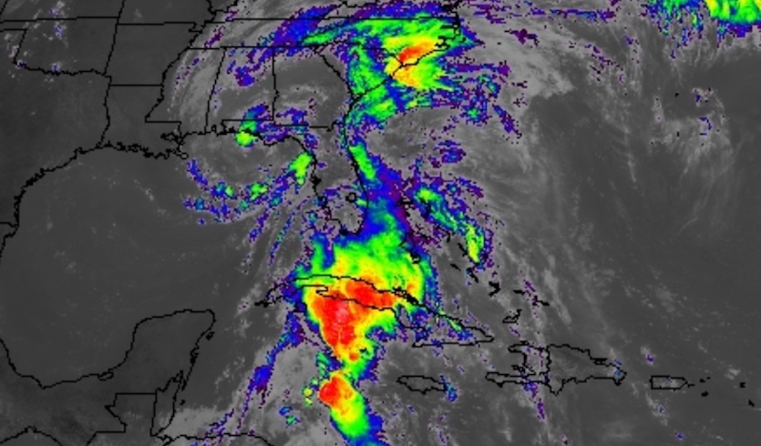
| Above: Visible satellite image of Subtropical Storm Alberto as of 1522Z (11:22 am EDT) Monday, May 28, 2018. Image credit: NASA/MSFC Earth Science Office. |
Heavy rains and gusty winds from Subtropical Storm Alberto pushed into the Florida Panhandle on Monday ahead of a Memorial Day landfall. Update (11 pm EDT Monday): Alberto made landfall around 5 pm EDT near Laguna Beach, FL. As of 11 pm EDT, Alberto had weakened to a subtropical depression, with top sustained winds of 35 mph. Alberto's center was located about 50 miles west-northwest of Dothan, Alabama. The depression was moving north at 12 mph. We'll have a new post on Alberto on Tuesday.
A tropical storm warning was in effect for the north Florida coast from the Alabama border eastward to the Suwanee River. A storm surge warning was in effect for the eastern portion of this area, from Mexico Beach to the Suwanee River. A storm surge of 2.8 feet was observed at Apalachicola just after 11 am EDT, and waters could hold steady or rise further between now and high tide in Apalachicola (around 3 pm EDT). High tide passed at Panama City around 10 am, where astronomical tidal levels will be dropping until Monday evening. The storm surge was running about 1.4 feet at Panama City at around 11 am.
As the center of Alberto approached from the south on Sunday night, a buoy located about 130 miles south-southeast of Pensacola (buoy 42039) reported top sustained winds of 45 mph and gusts to 58 mph. The buoy was reporting west winds below tropical storm force on Monday morning, suggesting that Alberto’s strongest winds are quite localized. At 10:37 am EDT, Apalachicola, FL, reported southeast winds sustained at 28 mph, gusting to 44 mph.
Looks like the center of #Alberto passed directly over the Pensacola South buoy (42039).... pic.twitter.com/OAcJdrBERa
— David Zierden (@FLClimateCenter) May 28, 2018
As is typical with a subtropical storm, Alberto had a highly asymmetric structure on Monday. A conveyor belt of rich moisture well east of its center was fueling strong thunderstorms from Cuba across South Florida, with the moisture channel extending north to the mid-Atlantic. Meanwhile, dry air from the western Gulf of Mexico had worked its way around the storm’s core and reduced the extent of showers and thunderstorms (convection) near the center.
With Alberto’s core convection weak and limited, and landfall only a few hours away, we can expect little if any significant change in the storm’s strength prior to landfall. The strongest winds will be east of Alberto’s center, with gusts above 40 mph and perhaps a few sustained winds in that range spreading across the Florida Panhandle and into far south Alabama and Georgia. Given the moist soil, there could be scattered tree damage and some power outages.
 |
| Figure 1. Infrared-wavelength satellite image of Alberto as of 1522Z (11:22 am EDT) Monday, May 28, 2018. The heaviest thunderstorms with Alberto are located well to the east of the storm center, along a channel of moisture extending from Cuba to North Carolina. Image credit: NASA/MSFC Earth Science Office. |
Heavy rains will be the main threat from Alberto over the next couple of days. As the storm moves northward through the Florida Panhandle and into Alabama on Monday night, it is expected to quickly decay into a subtropical depression. Its remnants will continue north, reaching the Ohio Valley by Wednesday and southeast Canada by Thursday. Rainfall could total 4-8”, with localized amounts in the 8-12” range, over the western Florida panhandle and parts of southern Alabama and Georgia. Widespread 2-4” amounts will extend across much of the Southeast, and localized totals could be well above that range. A concentrated area of heavier rains is expected over the Carolinas in association with the moisture channel to the east of Alberto.
The heaviest rains will continue to be in the moisture channel well east of Alberto’s center—especially across Cuba, where 5-10” of additional rain is possible. Storm totals of 25” in Cuba are not out of the question.
 |
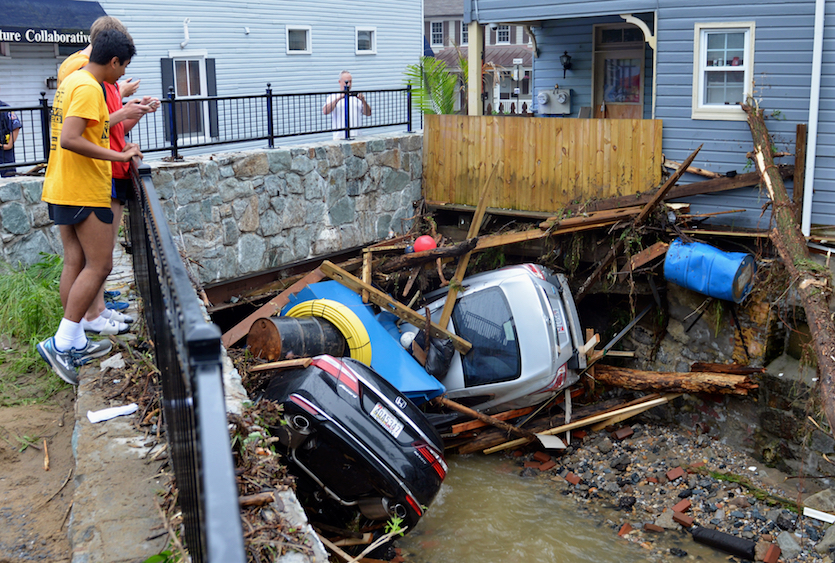
| Figure 2. Residents gather by a bridge on Monday, May 28, 2018, to look at cars left crumpled in one of the tributaries of the Patapsco River that burst its banks as it channeled through historic Main Street in Ellicott City, Maryland, on Sunday, May 27. Image credit: AP Photo/David McFadden. |
Exceptionally heavy rains in a small area fuel a high-impact flash flood
Instead of a setting for holiday festivities, the historic downtown of Ellicott City, Maryland, was a disaster scene on Monday following a devastating flash flood on Sunday—the town’s second in less than two years. A member of the National Guard who was helping to rescue people on Sunday was swept away and is missing in the wake of the flood, according to Howard County officials. Videos of the raging waters pouring through the town’s narrow main street were eerily reminiscent of the Ellicott City flood of July 30, 2016, which devastated the city’s compact downtown. It’s easy to imagine damages from Sunday potentially matching or exceeding the initial estimates of $22 million from the 2016 flood, which killed two people.
Radar-estimated rainfall of 5-10” in a small area from Ellicott City to Baltimore is supported by surface observations. Volunteers with the high-quality CoCoRaHS network (Community Collaborative Rain, Hail, and Snow Network) reported 9.47” at Catonsville (just east of Ellicott City) and 7.40” at Ellicott City for the 24 hours ending at 7 am EDT Monday. CoCoRaHS uses manual rain gauges that are old-school in style but ideal for heavy-rain measurement, assuming they are properly sited. A personal weather station at Catonsville reported a phenomenal 13.38” between 3 PM and 9 PM EDT Sunday, with 12.21” of that total measured between 3 and 6 PM. At least two other nearby PWSs reported double-digit rainfall amounts (thanks to Alex Lamers, @AlexJLamers, for tweeting this). PWS rain gauges can over- or under-estimate heavy rains by large amounts, so any PWS amounts would need to be confirmed before entering the official record. Still, very localized amounts greater than 10" are not out of the question for Sunday's storm, given the intense rainfall rates.
Maryland’s all-time precipitation record for a 24-hour period is 14.75”, recorded at Jewell (near the west side of Chesapeake Bay) on July 26-27, 1897.
How could this happen?
“They say this is a once-every-1,000-years flood, and we’ve had two of them in two years,” said Maryland governor Larry Hogan at a Sunday news conference. Scientists have plenty of time to carefully assess the influence of human-produced climate change on the occurrence of two extraordinarily heavy rains and devastating floods across this same small area within two years. Suffice it to say for now that (a) the most intense rain events are becoming more intense and frequent across the United States and in many parts of the world, a result that matches our understanding of the physics of heavy rainfall and global warming; and (b) the increase in development just upstream of Ellicott City over the past 20 years has almost certainly added to the town’s vulnerability to flash flooding (see this excellent Baltimore Sun analysis).
We’ll update this post late Monday and will return with our next full post on Tuesday. You’ll also find updates at the weather.com story on Alberto. Here’s wishing our U.S. readers a peaceful and meaningful Memorial Day!


