| Above: This infrared image from 0352Z Monday, May 28, 2018 (11:52 pm EDT Sunday night) shows that the core of Alberto was devoid of strong thunderstorms; the heaviest activity was well away from the storm’s center, over Cuba and the Bahamas. |
Subtropical Storm Alberto continues on track for a Monday encounter with the Florida Panhandle. Update: As of 8 am EDT Monday, Alberto was centered about 100 miles south-southeast of Destin, moving northwest at 9 mph. Alberto’s top sustained winds were holding at 65 mph. Tropical storm warnings were in place from the Mississippi/Alabama border to the Suwanee River in Florida. In addition, a storm surge watch was in effect from Navarre to the Suwanee River, FL. Inundations at high tide of up to 2-4 feet are possible within the watch area.
Still subtropical
It now appears that Alberto is unlikely to make the transition into a tropical storm. Subtropical storms gain their energy primarily from upper-level features rather than from a warm ocean. Alberto developed toward the east side of an upper-level trough, which gave the storm impetus for development but kept it under strong wind shear that pushed thunderstorms to the east end of Alberto’s center. Such asymmetry is typical for subtropical storms.
If you’ve ever wondered what a subtropical cyclone typically looks like, Alberto is it. Pronounced dry slot, involvement with an upper low or shortwave, Central convection lopsided downshear left, and a warm conveyor belt well displaced around its east side. Gorgeous. pic.twitter.com/wpUqaqFGxp
— David Roth (@DRmetwatch) May 27, 2018
As wind shear eased on Sunday, showers and thunderstorms (convection) clustered more tightly around Alberto’s west side. However, a strong dry slot arced around the storm just to its east, pinching off convection on that side and hindering Alberto’s ability to form a symmetric core. In addition, sea-surface temperatures (SSTs) along Alberto’s track through the eastern Gulf have been close to the minimum of 26°C (79°F) usually needed for tropical development. Together, these factors have kept Alberto from developing the shield of thunderstorms around a warm core needed to qualify as a tropical storm. By Sunday night, a ribbon of dry air had almost completely encircled Alberto, and the convection near the storm’s center had dwindled dramatically—not an auspicious sign for any last-minute strengthening.
At 12:50 am EDT Monday, buoy 42039 (located about 130 miles south-southeast of Pensacola, FL) reported north-northwest winds of minimal tropical storm strength—35 knots (39 mph), gusting to 47 knots (54 mph).
The forecast for Alberto
There has been no dramatic change to the track or intensity forecast for Alberto since Sunday morning. Alberto’s center is now swinging west of due north, around the north side of the upper-level low. That motion will bring Alberto onshore near the western end of the Florida Panhandle on Monday, most likely around midday to early afternoon. SSTs are slightly warmer between Alberto and the Florida coast, which in theory could help the storm gain some organization overnight. However, given Alberto’s lack of thunderstorms Sunday night, this prospect seems very unlikely.
The official NHC forecast as of 11 pm EDT Sunday has Alberto crossing the coast as a 65-mph subtropical storm between Pensacola and Panama City. Computer model guidance from 18Z Sunday is in strong agreement on this general track and timing; if anything, the guidance suggests a slight bit of weakening. The strongest winds on Monday can be expected from the point of landfall eastward to the Apalachicola area. Tropical-storm force winds (sustained at 40 mph) extended up to 115 miles from Alberto’s center on Sunday night, although Alberto’s peak winds will quickly weaken as the center moves inland from the coast.
 |
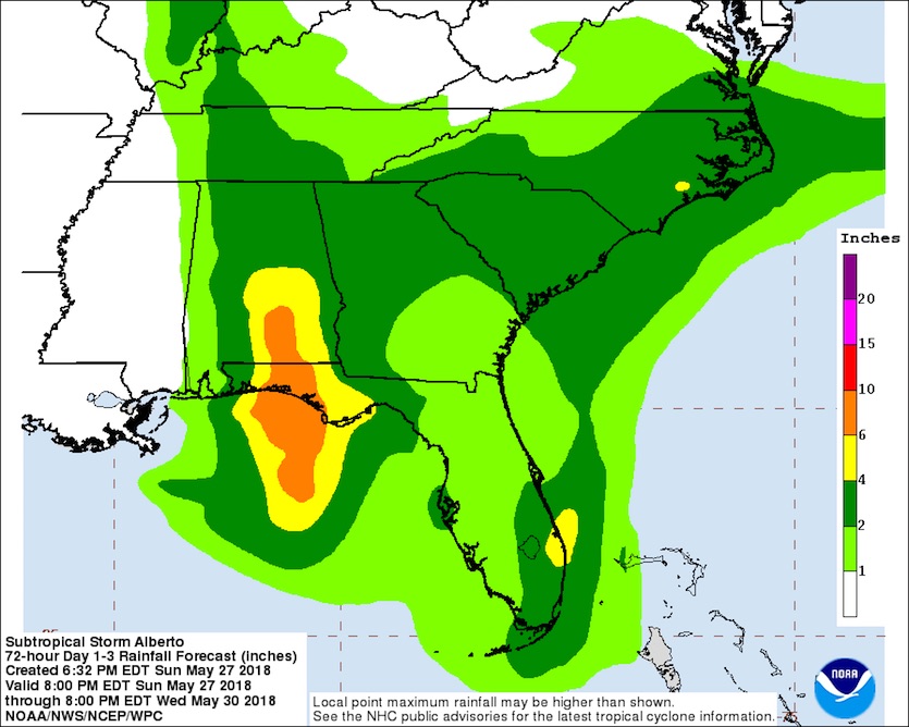
| Figure 1. Rainfall forecast from Alberto for the 72-hour period from 8 pm EDT Sunday, May 27, through Wednesday, May 30, 2018. Image credit: NOAA/NWS/WPC, via NHC. |
Heavy rains will be the main threat from Alberto. A swath of 4-10” totals is predicted close to the center of Alberto as it moves from south to north into central Alabama. The broad circulation associated with Alberto will also produce a second swath of widespread 2-4” rain, with larger totals locally, across South Florida as well as northern Georgia and the Carolinas.
Much heavier rains have been persisting across Cuba long after Alberto’s passage just west of the island on Saturday. Isolated rain totals could reach 25” in Cuba by the time Alberto’s influence is gone. Alberto’s remnants could also enhance pockets of heavy rain in parts of the Midwest and into southeast Canada later this week.
 |
| Figure 2. Water rushes through Main Street in Ellicott City, Md., on Sunday, May 27, 2018. After the floodwaters receded, emergency officials had no immediate reports of fatalities or injuries. But by nightfall first responders and rescue officials were still going through the muddied, damaged downtown, conducting safety checks and ensuring people evacuated. Image credit: Libby Solomon/The Baltimore Sun via AP. |
Flood devastation redux in a historic Maryland town
The broad channel of warm, moist tropical air feeding rains on Cuba and South Florida extends all the way to the mid-Atlantic. In northern Maryland, rich moisture intersecting with a weak frontal boundary on Sunday afternoon led to “training” thunderstorms, huge localized rain totals, and a colossal flash flood in downtown Ellicott City—the same scenic town battered by destructive flooding less than two years ago, on July 30, 2016. Videos of the raging waters pouring through the town’s narrow main street were eerily reminiscent of those from 2016. No fatalities or missing people had been reported as of late Sunday night, according to the Baltimore Sun, but it’s easy to imagine damages potentially matching or exceeding the initial estimates of $22 million from the 2016 flood, which killed two people.
It’s happening all over again. Main Street in @EllicottCity with devastating flooding. @CairnsKcairns @FOXBaltimore @wbaltv11 @wjz video courtesy my sister Kali Harris. (Explicit language) #EllicottCity #Maryland pic.twitter.com/IuwBRyPRzW
— Jeremy Harris (@JeremyHarrisTV) May 27, 2018
Exceptional rain totals in a small area
A personal weather station about three miles east of downtown Ellicott City at Catonsville, MD, reported a phenomenal 13.38” between 3 PM and 9 PM EDT Sunday, with 12.21” of that total measured between 3 and 6 PM. At least two other nearby PWSs reported double-digit rainfall amounts (thanks to Alex Lamers, @AlexJLamers, for tweeting this). Radar-estimated precipitation on Sunday was in the 5-10” range across an east-west strip that included the Ellicott City area. PWS rain gauges can over- or under-estimate heavy rains by large amounts, so I’ll be eager to see reports on Monday from CoCoRaHS volunteers. CoCoRaHS—the Community Collaborative Rain, Hail, and Snow Network—uses manual rain gauges that are old-school in style but ideal for heavy-rain measurement (assuming they are properly sited).
Maryland’s all-time precipitation record for a 24-hour period is 14.75”, recorded at Jewell (near the west side of Chesapeake Bay) on July 26-27, 1897.
It’s already obvious that the storms affecting Ellicott City were highly localized. As of 8 PM EDT, Baltimore Inner Harbor had picked up 3.08”, but Baltimore-Washington International Airport had received only 1.04”. The amounts were even more paltry at Dulles International Airport (0.01”) and Hagerstown (0.01”). Washington National Airport received only a trace.
“They say this is a once-every-1,000-years flood, and we’ve had two of them in two years,” said Maryland governor Larry Hogan at a Sunday news conference. Scientists have plenty of time to carefully assess the influence of human-produced climate change on the occurrence of two extraordinarily heavy rains and devastating floods across this same small area within two years. Suffice it to say for now that (a) the most intense rain events are becoming more intense and frequent across the United States and in many parts of the world, a result that matches our understanding of the physics of heavy rainfall and global warming; and (b) the increase in development just upstream of Ellicott City over the past 20 years has almost certainly added to the town’s vulnerability to flash flooding (see this excellent Baltimore Sun analysis).
We’ll have our next update on Alberto by midday Monday.


