| Above: 93L near the Cabo Verde Islands off the coast of Africa, as seen on Tuesday morning, August 29, 2017, by the MODIS instrument on NASA's Terra satellite. |
A tropical wave located near the Cabo Verde Islands on Tuesday morning has the potential to be Tropical Storm Irma late this week, and could pose a long-range threat next week to the Lesser Antilles Islands. Satellite images on Tuesday morning showed that 93L had a modest amount of heavy thunderstorm activity that was steadily growing in organization, with a prominent low-level spiral band on the south side and plenty of spin apparent in the cloud pattern. Conditions were favorable for development, with sea surface temperatures (SSTs) near 28°C (82°F)—more than 1°C (2°F) above average, moderate wind shear of 10 - 20 knots, and a moist surrounding atmosphere with a mid-level relative humidity of 70%. Wind shear was predicted to be in the low to moderate range, 5 – 15 knots, on Tuesday through Sunday, according to the 12Z Tuesday run of the SHIPS model. This should allow the wave to develop into a tropical depression by Friday over the central tropical Atlantic, as predicted by the 0Z Tuesday runs of our top three models for predicting tropical cyclone genesis--the European, GFS, and UKMET models. These models have been persistent in developing the new system over multiple runs, giving increased confidence that we will see a new tropical depression in the Atlantic late this week.
The wave is predicted to head generally west-northwest at 15 – 20 mph through Friday, then assume a more westerly or even west-southwesterly track over the weekend, as a strong ridge of high pressure builds to the north of 93L. This would potentially bring 93L into the Lesser Antilles Islands as early as Tuesday, September 5, as predicted by the 0Z Tuesday run of the European model and most of its 50 ensemble members. The GFS model was much less concerning, with its 0Z and 6Z Tuesday runs predicting that a strong trough of low pressure would turn 93L to the northwest early next week, resulting in 93L missing the Lesser Antilles Islands by more than 500 miles. It is too early to stress out about the European model’s solution until 93L consolidates into a tropical depression, though, as typical errors in a 7-day track forecast are well over 500 miles. In its tropical weather outlook issued at 8 am EDT Tuesday, the National Hurricane Center gave 93L 2-day and 5-day odds of development of 70% and 90%, respectively.
 |
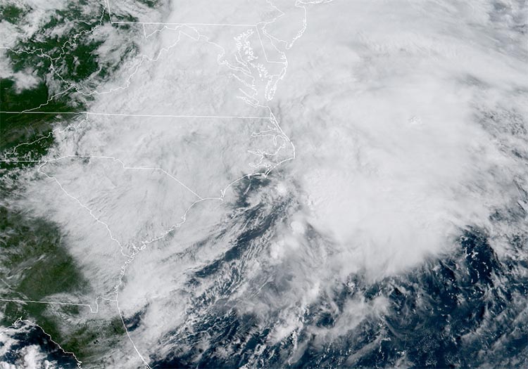
| Figure 1: Potential Tropical Cyclone 10 off the coast of Georgia and South Carolina, as seen by the GOES-16 satellite at 10:30 am EDT Tuesday, August 29, 2017. Image credit: NOAA/RAMMB. GOES-16 data are considered preliminary and non-operational. |
Tropical Storm Warning in North Carolina for PTC Ten
A Tropical Storm Warning was posted for portions of the coast of North Carolina late Tuesday morning for Potential Tropical Cyclone Ten (PTC 10), which was moving northeast at 17 mph along the coast of North Carolina. Satellite images on Tuesday morning showed that PTC 10 had a modest amount of heavy thunderstorm activity that was not changing much in intensity or organization. High wind shear of 30 - 40 knots was hindering development, and it is unlikely that the storm will organize into a named storm or generate any sustained winds in excess of 40 mph. The main threat from PTC 10 is isolated flooding issues, as 1 – 3” of rain is expected in coastal North Carolina, Virginia, Maryland, and Delaware through Wednesday. In its tropical weather outlook issued at 8 am EDT Tuesday, the National Hurricane Center gave PTC Ten 2-day and 5-day odds of development of 30%. The storm will merge with a cold front and become extratropical by Wednesday, becoming a hurricane-strength extratropical storm Wednesday night. The storm will bring some high surf to portions of the coasts of North Carolina and Virginia through Wednesday.
 |
| Figure 2. Projected total additional rainfall from PTC 10, from the 11 am EDT August 29, 2017 advisory from NHC. |
Southwest Mexico and the Baja Peninsula at risk from 94E
An area of low pressure located in the Eastern Pacific several hundred miles south of Manzanillo, Mexico (Invest 94E) is bringing a widespread area of heavy thunderstorms to the waters just offshore from the southwest Mexican coast, as seen on satellite images. Wind shear was moderate on Tuesday morning, at 15 - 20 knots, but is expected to fall to the low to moderate range, 5 – 15 knots, Tuesday afternoon through Friday, according to the 12Z Tuesday run of the SHIPS model. This should allow 94E to organize into a tropical depression over the warm 29.5°C (85°F) waters of the Eastern Pacific later this week. The system has an exceptionally moist atmosphere to work with, with a mid-level relative humidity near 85%. Our top three models for predicting tropical cyclone genesis--the European, GFS, and UKMET models—all developed 94E in their 0Z Tuesday runs, and predicted a north-northwesterly track that would take the storm close to the southern tip of the Baja Peninsula on Thursday and Friday. 94E will be capable of bringing torrential rains of 5 – 10 inches to coastal southwest Mexico and the southern end of the Baja Peninsula, resulting in life-threatening flash floods and mudslides. In their 8 am EDT Tuesday Tropical Weather Outlook, NHC gave 94E 2-day and 5-day odds of development of 80% and 90%, respectively.


