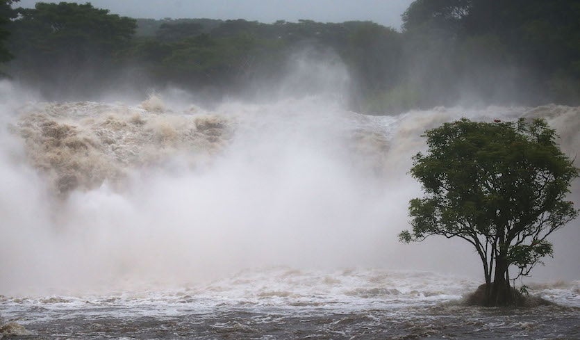
| Above: Floodwaters from the Wailuku River near Hilo run downstream on Hawaii’s Big Island on Thursday, Aug. 23, 2018. Image credit: Mario Tama/Getty Images. |
Even as its core was being pulled apart by strong wind shear on Friday, Hurricane Lane (demoted to a tropical storm on Friday evening) continued to trigger an array of havoc across the Hawaiian Islands. Torrential rains were spreading northward across Oahu to Maui after Lane’s outer rainbands dropped more than 30” on parts of the Big Island, where flooding was described by the Central Pacific Hurricane Center as “catastrophic”. Meanwhile, two fast-moving wildfires broke out on Friday in the drier downslope flow along Maui’s west coast, causing at least one injury.
As of 5 pm EDT (11 am HST) Friday, the poorly defined eye of Hurricane Lane was located about 150 miles south of Honolulu and about 130 miles west of Kailua-Kona, moving north at 5 mph. The storm’s top sustained winds were 105 mph, making Lane a Category 2 hurricane. A Hurricane Warning remained in effect for Oahu, Maui, Lanai, Molokai, and Kahoolawe, with a Tropical Storm Warning for the Big Island and a Tropical Storm Watch for Kauai and Niåihau. Update (noon EDT Saturday): As of 11 am EDT (5 am HST) Saturday, Lane's top sustained winds were down to 60 mph, making it a tropical storm. All hurricane watches and warnings were dropped; the entire state remained under a tropical storm warning, except for Kauai and Niihua, which were under a tropical storm watch, and Hawaii County (Big Island), where all warnings and watches had been dropped. Lane will continue to weaken and may be a tropical depression by Sunday. Radar loops showed heavy rains continuing to push across the islands from Oahu to Maui on Friday night, so there remains a significant flood risk.
.") |
| Figure 1. Infrared image of Hurricane Lane southwest of Hawaii’s Big Island at 3:15 pm EDT Friday, August 24, 2018 (9:15 am HST). Image credit: NASA/MSFC Earth Science Branch. |
On satellite imagery from Friday morning, Lane resembled a huge thunderstorm complex or a strong tropical storm more than a hurricane. Infrared imagery showed a near-circular blob of intense showers and thunderstorms (convection), with no eye evident. Officially, Lane was nearly stationary, but that net motion obscured two important trends: the mid-level circulation and most of the storms convection was being pushed toward the islands by 35 – 45 mph of southwesterly wind shear, while the low-level circulation was moving much more slowly. Over time, this strong shearing action will rip Lane apart, and the remnant low-level circulation will head west with the prevailing trade-wind flow, taking it away from the islands. Lane is predicted to weaken to Category 1 strength on Friday night and to tropical-storm strength on Saturday.
Before it falls apart, Lane will continue to spin large amounts of moisture across the islands, racking up the rainfall totals where the flow is heading upslope. Lane’s slight northward motion from Friday into Saturday could lead to intensified rains from Oahu to Maui, including the Honolulu area. A flash flood watch is in effect until Saturday afternoon for the entire state of Hawaii.
High surf will also batter the south-facing coasts of the islands. The latest marine forecasts on Friday afternoon called for waves as high as 29 feet across the leeward waters of Oahu, which extend southward from the Honolulu area.
The risk of hurricane-force sustained winds has become negligible with Lane, although there is still the potential for some areas to be affected by sustained tropical-storm-force winds (39 mph or stronger), especially from Oahu to Maui. These winds can be strong enough to topple trees and power lines, especially with saturated soils.
 |
| Figure 2. Floodwaters from Hurricane Lane made the intersection of Kamehameha Avenue and Pauahi Street impassable on Thursday, Aug. 23, 2018, in Hilo, Hawaii. Image credit: Hollyn Johnson/Hawaii Tribune-Herald via AP. |
Fire and rain
Lane has produced more than 30” of rain on parts of the eastern Big Island. As of 8 am HST, Hilo had racked up at least 3.08” on Friday, on top of 16.85” recorded on Wednesday and Thursday and 26.61” for the month of August through Thursday. Friday’s rains are pushing Hilo far beyond its previous all-time wettest August in 68 years of recordkeeping (26.92”, set in 1991). The 24-hour precipitation summary for Hawaii issued at 2:45 pm EDT Friday (8:45 am HST Thursday) included:
Hakalau (Big Island): 21.71”
Saddle Quarry (Big Island): 20.90”
Mountain View (Big Island): 12.38”
Kilohana (Kauai): 5.07”
In a bizarre twist, the breezy downlope conditions on Maui’s west coast boosted the spread of two brush fires about four miles apart. People were evacuated from about 100 homes in the town of Lahaina ahead of the first fire, which was reported around 1 am HST Friday. Officials from Maui County reported on Facebook that the fire had spread to roughly 300 acres by Friday morning. One woman was hospitalized because of burns, according to a county spokesperson quoted by Hawaii News Now. The second fire reportedly developed across the highway from a Hyatt resort south of Kaanapali.
No injuries had been reported from the widespread flooding across Hawaii as of Friday morning, although weather.com reported that at least five tourists were rescued from a rental home in Hilo.
I hope they get containment and the rain comes fast, these winds are not helping #Lahaina #Maui @Maui_EMA @mauipd @CountyofMaui pic.twitter.com/X3WUZWBbGj
— Stephen Lai (@slaiguy) August 24, 2018
 |
| Figure 3. The Ala Wai watershed, which runs from the Ko’Olau mountain ridge across densely populated Honolulu to Waikiki Beach. Image credit: U.S. Army Corps of Engineers. |
A major flood concern: the Ala Wai Canal in Honolulu
The biggest single threat to property and people from heavy rain in Hawaii may be in the Honolulu area, where Lane’s downpours run the risk of triggering flooding from the Ala Wai Canal. Nearly a century old, the state-controlled canal was built to drain nearby wetlands and facilitate the development of the Waikiki area. The canal runs parallel to the Waikiki beachfront. Three perennial streams flow into the canal from the higher terrain of the Makiki, Manoa, and Palolo Valleys, which sit just above the coastal Honolulu area. If moist winds blow from south to north against this steep terrain, it can lead to very heavy rains at elevation and floodwaters that pour into Honolulu in as little as 30 minutes.
The Ala Wai canal has overflowed on several occasions, including November 1965, December 1967, and September 1992 (during Hurricane Iniki, whose center passed about 100 miles west of Honolulu before striking Kauai from the south). In addition, an October 2004 storm flooded Manoa Valley and a March 2005 storm flooded Makiki. Winter-type storms are responsible for most of the major flooding events in Oahu. No hurricanes or tropical storms are known to have made landfall on the island.
Modeling studies by the U.S. Army Corps of Engineers indicate that a flood with an expected recurrence interval of 100 years (i.e., a “100-year flood”) could inundate much of the Waikiki area, damaging some 3000 structures and incur roughly $1.1 billion in damage. The embedded 4-minute video below, from the Corps of Engineers, gives an excellent overview of the canal and the flood risk.
The Hawaii Star-Advertiser reported on Friday that no efforts were in place to safeguard against the canal overtopping its banks, other than clearing debris from the canal. Along with the hundreds of thousands of housed residents and tourists packed into the densely populated Honolulu area, there are an estimated 2000-plus homeless residents on Oahu. Some reportedly intend to hunker in place rather than risk losing their few possessions.
 |
| Figure 4. Experimental output from a research version of the Weather Research and Forecasting model (WRF-ARW), based on a starting point of 0Z Friday, August 24, 2018, shows Hurricane Lane passing to the south of Oahu as winds turn to the southeast over the island at 17Z (1 pm EDT or 7 am HST) Saturday, August 25. Very heavy rainfall rates (greater than 3”/hr) are suggested over parts of northeast Oahu. This is not intended as a specific forecast; please consult the Central Pacific Hurricane Center and local authorities for official forecasts and guidance. Image credit: University of Hawaii at Manoa. |
Winds around Lane will be blowing from the east or east-northeast until Saturday, when they will likely shift to a more southeasterly direction as Lane begins to head west. This shift will increase the onshore component to the flow, which could exacerbate any rains that do develop on Saturday across southern Oahu. It is also possible, but by no means certain, that the north edge of Lane’s convective core will push onto one or more of the islands from Oahu to Maui from Friday night into Saturday. If so, this would significantly raise the odds of major flooding.
For more details on potential impacts from Lane, see the frequently updated weather.com feature story.


