| Above: An early-spring sunset over the icy Chukchi Sea near Barrow (Utqiaġvik), Alaska, documented during the OASIS field project (Ocean_Atmosphere_Sea Ice_Snowpack) on March 22, 2009. Image credit: UCAR, photo by Carlye Calvin. |
A tenacious weather pattern that led to the loss of great chunks of Bering Sea ice in February is now pushing ever-warmer air well into the Arctic. The result is a phenomenally strong and prolonged “warm wave” that’s vanquishing monthly temperature records across northwest Alaska.
At Utqiaġvik (Barrow), temperatures have hovered between 10°F and 30°F since Saturday. Similar readings are expected almost every day into next week. That may not sound like a balmy regime, but consider that the average high and low for March 25 are –5°F and –18°F.
In 99 years of recordkeeping at Utqiaġvik, no March has ever ended up with a mean temperature above zero. In the first 25 days of March 2019, the average has been 1.9°F. Given the forecast, this month is sure to leave the previous warmest March average (-0.7°F) in the dust—and that record was set just last year, in March 2018.
Kotzebue, about 300 miles southwest of Barrow on the Chukchi Sea, is overperforming even more. From March 1 to March 25, the town’s monthly average to date of 20.5°F was a full 20.1°F above the norm for that period! As is the case in Utqiaġvik, Kotzebue is already running far milder than its previous monthly average for any March (13.5°F in 1998). The forecast for the next week implies that this month’s average will climb even further above 20°F before the month is out.
Update (March 27): According to climatologist Brian Brettschneider, the biggest departure from a March average for any U.S. location is the 20.9°F above normal notched at Circle Hot Springs, AK, in March 1965 (relative to the 1931-1960 norm). It looks as if Koztebue and Eagle will exceed that margin, and Deadhorse may end up 23°F above normal, according to Brettschneider.
 |
| Figure 1. Temperatures are projected by the 12Z Tuesday run of the GFS model to run 20-28°C (36-50°F) above average early Sunday morning, March 31 (12Z Sunday), across far northern Alaska and the adjacent Chukchi and Beaufort seas. This corresponds to readings close to or just above the freezing mark, as opposed to typical temperatures that are near or below 0°F in late March. Image credit: tropicaltidbits.com. |
Unusually mild air has prevailed this month over much of Alaska, western Canada, and far northeast Russia, occasionally spiking to ludicrous levels. On March 19, as reported by weather.com’s Jon Erdman, temperatures soared to all-time March highs at six far-flung Alaska locations, including 67°F at Sitka. Less than 400 miles from the Arctic Circle in Canada, Yohin Lake hit 21.8°C (71.2°F), the earliest 20°C reading ever recorded in the Northwest Territories. In another all-time high for March, Tofino, British Columbia, rocketed to 24.5°C (76.1°F)—a reading that would also set a monthly record had it occurred in November, December, January, February, or April.
The warmth on March 19 extended all the way to Seattle, which hit 79°F, setting a record for its warmest March temperature on record.
This might put the Tofino stat in a better visual perspective, temperature approximately 5 standard deviations above normal for March 19th (CYAZ). This temperature would also beat a couple daily records in the month of June. (Graph: @datawithZ) #BCheat pic.twitter.com/BISMnDA1PG
— Tyler Hamilton (@50ShadesofVan) March 19, 2019
Why now?
Just as predicted by climate models, long-term warming associated with human-produced greenhouse gases has made its mark on the Arctic more than just about anyplace else—a phenomenon called polar amplification. The 2018 Fourth National Climate Assessment noted: "The rate at which Alaska’s temperature has been warming is twice as fast as the global average since the middle of the 20th century....Temperatures have been increasing faster in Arctic Alaska than in the temperate southern part of the state, with the Alaska North Slope warming at 2.6 times the rate of the continental U.S. and with many other areas of Alaska, most notably the west coast, central interior, and Bristol Bay, warming at more than twice the continental U.S. rate."
So perhaps it's no surprise to see temperatures soaring to such unprecedented heights in and around northern Alaska. But why have the last few weeks been such a standout?
The immediate culprit is the atmospheric pattern that’s brought very strong winter storms into the northwest Pacific Ocean. Ahead of the North Pacific storms, recurrent bouts of shrieking southerly winds have spread mild air far to the north across the Bering Sea and adjacent parts of Russia and Alaska. Further east, the southerly flow has pumped up strong atmospheric ridging along the west coast of Canada and the northern U.S., leading to unusual periods of sunny weather and record-warm air, as noted above. And on the east side of those recurrent upper ridges, strong northerly flow has pushed a series of unusually cold air masses across much of the U.S. during the last two months.
949mb low in the western Bering Sea Monday morning plowing north. Peak wind 77kt (89mph) at Adak Sunday evening. South to southeast winds ahead of the low center already chewing up sea ice near Alaska. Loop courtesy @NWSAlaska. #akwx @Climatologist49 pic.twitter.com/Up2erIFHHI
— Rick Thoman (@AlaskaWx) March 25, 2019
In early March, sea ice extent in the Bering Sea dipped below the all-time seasonal low that was set just last year, covering less than a third of the 1981-2010 median extent. Fringes of the reliable ice pack across the Chukchi and Beaufort Seas, which border Alaska’s northern coast, have also been affected by the pattern, according to researcher Zack Labe (University of California, Irvine).
“Southerly winds act to push the sea ice poleward, especially lifting it away from the landfast ice along the North Slope of Alaska,” said Labe.
It’s February, the coldest month of the year. We have open water in front of Utqiagvik. It is 30 F out at 11:20 at night. Strange days indeed. pic.twitter.com/9HZB6wbpna
— Dr. Anne Jensen (@ajatnuvuk) February 8, 2019
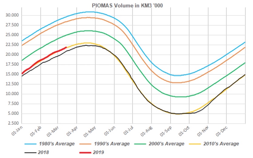
Sea ice extent in other portions of the Arctic has not been at record-low levels, however. For the Arctic as a whole, sea ice extent reached its apparent annual maximum on March 13, tying with 2007 for seventh lowest in the 40-year satellite record. "So far, the winter has been good for Arctic sea ice," said blogger Neven at the Arctic Sea Ice Forum in a February post.
 |
| Figure 2. Arctic sea ice volume as calculated by PIOMAS (the Pan-Arctic Ice Ocean Modeling and Assimilation System) shows that the volume for 2019 thus far has been closely following the average for the 2010s–which is an improvement over 2018, but far less than the ice volume calculated for previous decades. The values above are shown in thousands of cubic kilometers. Image credit: gerontocrat, via Arctic Sea Ice Forum. |
With sunlight still weak and temperatures not much above freezing, winds have been the main nemesis for sea ice in and near the Bering Sea, Labe added. “Although air temperatures can reach more than 20°C above average during these warm events, sea ice declines are still mostly wind-driven during this time of year."
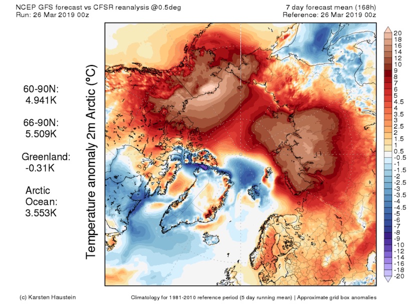
For at least the next week, there's little change in sight for extreme early-spring warmth throughout the western Arctic, with focal points centered on northern Alaska and north central Siberia (see Figure 3 below).
 |
| Figure 3. The 0Z Tuesday run of the GFS model predicts that temperatures over the next week (from 0Z Tuesday, March 26, to 0Z Tuesday, April 2) will average more than 18°C (32°F) above the 1981-2010 norm across large parts of the northern Alaska coast and adjacent Beaufort and Chukchi seas. Image credit: Karsten Haustein. |


