
| Above: True-color satellite image of Invest 95L east of The Bahamas at 1612Z (12:12 pm EDT) Wednesday, September 11, 2019. Image credit: tropicaltidbits.com. |
A tropical wave festering near the Southeast Bahamas may gradually organize as it heads toward Florida and the eastern Gulf of Mexico. In its 2 pm EDT Wednesday Tropical Weather Outlook, the National Hurricane Center gave 95L a 40% chance of becoming at least a tropical depression by Friday and a 60% chance by Monday.
Already, Invest 95L is producing a large area of strong thunderstorms (convection), stretching from near eastern Cuba into the Northwest Atlantic. Satellite imagery shows extensive upper-level outflow toward the east, but wind shear of about 20 knots is inhibiting outflow toward the west. The wave is embedded in a modestly moist atmosphere (mid-level relative humidity of around 55%). Although Hurricane Dorian churned up the waters as it tore through the Northern Bahamas, sea surface temperatures along 95L’s path—slightly south of Dorian’s—remain above 28°C (82°F), more than warm enough for tropical development.
The diffuse center of 95L will approach Florida by Friday, pushing heavy rain across the peninsula over the weekend. There is no closed circulation with 95L at midday Wednesday, and there is not much time for one to develop and intensify before reaching Florida, but a tropical depression is certainly possible, as noted by NHC.
The 0Z ensemble runs of the European and GFS models differ sharply on whether 95L will move across southwest Florida and reach the coast between Mississippi and the Florida Panhandle (the favored European track) or angle further westward across the Florida Straits or far south Florida and move inland between Texas and Mississippi (the GFS take). Among operational runs, the 0Z European takes 95L into the central Florida Panhandle by Sunday night, while the GFS brings it near the Alabama/Mississippi border on Monday. The 0Z UKMET model is the easternmost solution of the three, taking 95L along Florida’s east coast and into the southern Appalachians.
Almost half of the GFS ensemble members bring 95L to tropical storm strength, which makes sense given the longer GFS tracks over the very warm waters of the Gulf, while only about 15% of Euro members produce a tropical storm. Nearly all members of both ensembles yield at least a tropical depression in the next few days. If 95L takes the more southerly route suggested by the GFS, it could allow the center to remain offshore for most or all of the next few days, which would raise the odds of significant development.
95L is tangled up with an upper-level low to its west, which will bring wind shear and dry air to the system. In order to intensify, 95L would have to fight off not only land interaction but also the effects of the moderate to strong westerly wind shear (10-20 knots) and dry air from the upper low. Sea surface temperatures across the eastern Gulf of Mexico are toasty—about 30°C (86°F), roughly 1°C above average—so there is ample oceanic fuel to support any development.
Widespread heavy rain is the safest bet with 95L. Most of the Southeast can expect at least 1” over the next few days, and a large area of 2-5” amounts—with even higher localized totals—can be expected wherever 95L comes ashore.
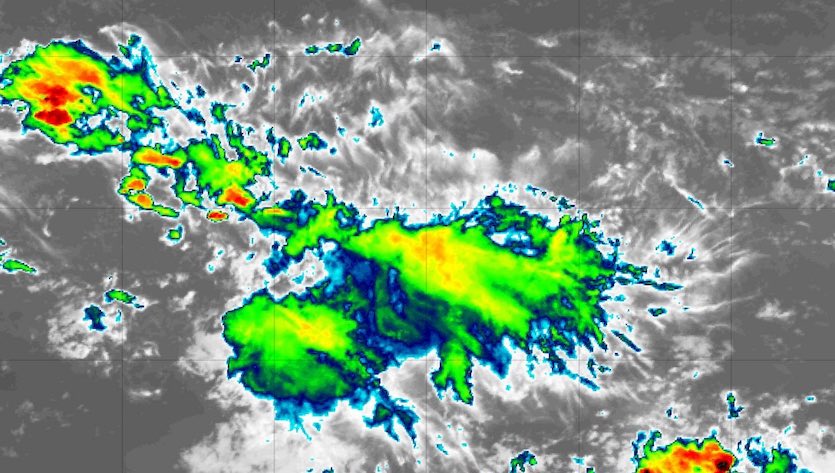 |
| Figure 1. Infrared satellite image of Invest 94L in the tropical Atlantic at 1655Z (12:55 pm EDT) Wednesday, September 11, 2019. Image credit: tropicaltidbits.com. |
Two other systems to watch
Elsewhere in the Atlantic, NHC is highlighting two Cape Verde-type waves in the Main Development Region of the deep tropics. One of these, Invest 94L, is located a few hundred miles east of the Lesser Antilles. Dry air had killed off nearly all convection around 94L on Tuesday. Thunderstorms managed to regenerate on Tuesday night, but an unfavorable pattern of upper level winds, together with strong wind shear (around 20 knots) will likely keep 94L from developing. The 0Z Wednesday GFS and European ensembles are unanimous in their lack of support for 94L, and NHC gives it only a 10% chance of development through Sunday.
The other wave, not yet tagged with an “invest” number, may be of more concern. Located in the eastern Atlantic south of the Cabo Verde Islands, this disturbance is fairly organized but has only a modest amount of convection. The 0Z run of the European model, and the 0Z, 6Z, and 12Z runs of the GFS model, show this wave intensifying into a tropical cyclone early next week after it passes the Lesser Antilles and enters the northeast Caribbean. The 0Z UKMET run did not show development.
It’s far too soon for a confident forecast that this wave will develop next week, but given the signals in the European and GFS models, we will need to keep an eye on it. NHC gives the wave a near-zero chance of development through Friday but a 20% chance through Monday.
Dr. Jeff Masters contributed to this post.


