| Above: Infrared image of Tropical Storm Barry at 1656Z (12:56 pm EDT) Thursday, July 11, 2019. Image credit: NASA/MSFC Earth Science Branch. |
A hurricane watch remained in effect Thursday from Cameron, Louisiana, east to the mouth of the Mississippi River, ahead of slow-moving, slow-organizing Tropical Storm Barry in the northeast Gulf. Although Barry may or may not reach hurricane strength before it comes ashore on Saturday, water will be its main threat, including the potential for 10” - 20” of rain, significant storm surge, and a riverine surge that could overtop some levees along the Mississippi south of New Orleans and approach levee tops in parts of the city itself.
A tropical storm warning is in effect from Morgan City east to the Pearl River, with a tropical storm watch eastward to the Mississippi/Alabama border. Also in a tropical storm watch are Lake Pontchartrain and Lake Maurepas, including the New Orleans metro area.
Mandatory evacuation orders were in place for parts of Plaquemines and Jefferson parishes, including Grande Isle. See the frequently updated weather.com article for more on evacuation orders as they are issued. People in the affected areas should consult local authorities for the latest on evacuations.
Barry's evolution
It's plain to see in satellite imagery that Barry is not the most organized tropical storm. Since moving offshore on Tuesday as a non-tropical disturbance, the system has struggled to morph into a tropical cyclone, with multiple low-level centers spinning amid a broad, diffuse circulation. Persistent northerly wind shear has driven dry air into the circulation at times, further impeding its organization.
On Thursday morning, a broad zone of thunderstorms (convection) was oriented east-west about 100 miles off the central Gulf Coast. The strongest thunderstorms were clustered just south of Louisiana, but another cluster of convection well to the east, about 200 miles south of Mobile, was closer to the low- and mid-level circulation features that appeared to be coalescing. It may take until Thursday night for convection to consolidate around this area, assuming that it does.
[#NerdTweet] Nowcasting this afternoon involves watching the next meso-vortex to rotate down into the southern semicircle. The last one did not get anchored to any deep convection & amplify. If the next one does, it could precede intensification and/or a SW tug on the circulation pic.twitter.com/abAVAJ9QZs
— Levi Cowan (@TropicalTidbits) July 11, 2019
At 11 am EDT Thursday, the National Hurricane Center placed the center of Barry about 95 miles south-southeast of the mouth of the Mississippi River, moving west at 5 mph. Barry’s top sustained winds were 40 mph, making it a minimal-strength tropical storm.
A cluster of intense storms on the fringe of Barry’s parent circulation swept through southeast Louisiana on Wednesday, dumping 4” – 8” rains across several parts of the New Orleans metro area with unofficial reports topping 10”. Widespread flooding hit the city core.
 |
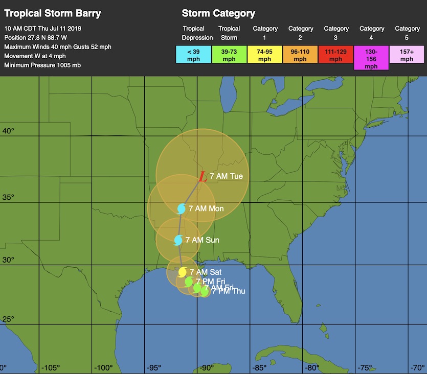
| Figure 1. WU depiction of official NHC forecast for Barry as of 11 am EDT Thursday, July 11, 2019. |
Forecast for Barry
Overall, there is high confidence that Barry will gradually arc west and then northwest toward the central Gulf Coast, coming onshore this weekend. At the same time, there is a good bit of uncertainty over the timing, location, and intensity of landfall. Possible landfall locations range from far northeast Texas (a scenario championed by the UKMET model for several runs) to the Mississippi coast (favored by the 06Z Thursday runs of the high-resolution HWRF and HMON models).
The European and GFS models, which tend to be the most reliable on track forecasts, have trended toward a middle-of-the-pack solution that brings Barry onshore in central or southeast Louisiana on Saturday. The official NHC forecast on Thursday morning was in line with this thinking, with Barry making landfall Saturday morning as a minimal Category 1 storm southeast of Lafayette and moving north toward the Mississippi Delta. Such a track would push the greatest surge, rain, and wind impacts across southeast Louisiana, to the right and ahead of of Barry's center.
It’s quite possible Barry will not reach hurricane strength, especially if it continues to struggle with a lack of consolidation. If we do see a period of significant strengthening, it will most likely be from Friday into Saturday, during the 24 hours or so before landfall, when Barry may be moving very slowly just off the southeast Louisiana coast over very warm sea surface temperatures of around 30°C (86°F). Strong wind shear of 20 - 25 knots may continue to inhibit Barry’s intensification, however.
 |
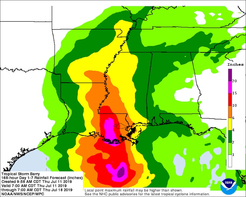
| Figure 2. Seven-day rainfall forecast showing the expected impact of Tropical Storm Barry from 7 am CDT Thursday, July 11, to 7 am July 18. Image credit: NOAA/NWS/WPC. |
The main threat from Barry: water
Regardless of its landfall strength, massive amounts of rainfall are likely from Barry, especially if it lingers for long near or just off the Louisiana coast. The latest seven-day rainfall forecast from the NOAA/NWS Weather Prediction Center (WPC) shows a corridor of 15-20” rains associated with Barry’s center tracking just west of the New Orleans area. Such a corridor could easily shift east or west depending on Barry’s exact track. These rainfall totals are from 7 am Thursday, so they do not include the rains that fell in New Orleans on Wednesday. Rains of 4-6” may extend as far north as southeast Arkansas.
Widespread flash flooding is very likely with this setup. In fact, WPC placed most of southeast Louisiana under a high-risk designation for excessive rains on Saturday. A high-risk rainfall outlook on Day 3 has only been issued in two other cases: with Hurricanes Harvey (2017) and Florence (2018), both of which produced multi-billion-dollar flooding.
Note that the biggest rainfall impacts may occur hours after Barry makes landfall.
Storm surge potential along the Gulf Coast and up the Mississippi
Barry is unlikely to intensify enough to generate a highly destructive storm surge, but significant and prolonged surge is still possible. As of midday Thursday, a storm surge warning is in effect for the Louisiana coast from the mouth of the Atchafalaya River to Shell Beach, where 3-6’ of inundation is possible at high tide. A storm surge watch, for a possible 2-4’ of inundation, flanks the warning area east to the Mississippi/Alabama border and west to Intracoastal City, LA. Also under a storm surge warning is Lake Pontchartrain, where 1-3’ of inundation is possible.
Storm surge is also expected to push up the Mississippi River toward New Orleans. The Mississippi has experienced record-prolonged flooding this year, and the arrival of an early-season tropical cyclone atop late-season flooding is an unusual and concerning prospect. See Jeff Masters’ post from Wednesday night on how even a Category 1 hurricane could produce a damaging storm surge in the New Orleans area.
As of Thursday morning, NOAA was predicting the Mississippi to crest at the New Orleans Carrollton Gage on Saturday at 19’, down from the forecast of 20’ on Wednesday. This forecast could change again depending on how Barry evolves, but the one-foot drop is a welcome shift, since the levees protecting the city are at least 20’ high (as confirmed Thursday by the U.S. Corps of Engineers). Some of the river levees south of Oakville and Caernarvon in Plaquemines Parish are at higher risk of being overtopped, according to the Corps, and intermittent overtopping could happen closer to the city due to wave action.
 |
| Figure 3. Visible satellite image of 93L at 12:05 pm EDT July 11, 2019. Image credit: tropicaltidbits.com. |
First tropical wave of 2019 worth watching: Invest 93L in Eastern Atlantic
It’s a little early in the season to be concerned about tropical waves coming off the coast of Africa, but we have our first tropical wave worthy of attention today. The wave, designated 93L by NHC on Thursday morning, was located in the far Eastern Atlantic several hundred miles southwest of the Cabo Verde Islands, and was headed west at 15 – 20 mph.
Satellite loops on Thursday afternoon showed that 93L had plenty of spin, and small area of heavy thunderstorms that were gradually increasing in areal extent and growing more organized. The SHIPS model diagnosed a moderate 10 – 20 knots of wind shear, and showed that the atmosphere surrounding 93L was quite dry, with a mid-level relative humidity of 50%. Sea surface temperatures (SSTs) were adequate for development, at 27°C (81°F).
Forecast for 93L
93L is caught up in a strong flow of easterly trade winds, and will continue to the west at 15 – 20 mph for the next five days. This will bring the disturbance into the Lesser Antilles Islands by Monday evening, and will also act to impede development, since fast-moving tropical waves have more difficultly aligning themselves vertically and getting organized.
As the system heads west, it will encounter a significant amount of dry air, as seen in the latest Saharan Air Layer Analysis. Though wind shear is predicted to be low to moderate and SSTs will be adequate for development, near 26.5 - 27°C (80- 81°F), this dry air will create hostile enough conditions that development into a tropical depression is unlikely over the next five days.
Approximately 20% of the 70 ensemble members of the 0Z Thursday runs of the European and GFS models showed 93L being a tropical depression or tropical storm on Monday as it moved through the Lesser Antilles. In their 8 am EDT Thursday Graphical Tropical Weather Outlook, the National Hurricane Center (NHC) gave 93L 2-day and 5-day odds of development of 10%. The next name on the Atlantic list is Chantal.
Jeff Masters co-wrote this post.


