| Above: New York City’s biggest snow of the 2018-2019 season occurred on November 15, 2018, when 6.4” accumulated. This was also the earliest 6”+ calendar day snowfall on record at the official Central Park observation site where snowfall records began in 1869. Image credit: Angela Weiss/AFP/Getty Images. |
Although the official snow season of 2018-19 doesn’t end until June 30, it is, by and large, over by the end of April for the vast majority of locations in the contiguous United States, aside from the high elevations of the Rocky Mountains and other mountainous sites in the country. Alaska, of course, will continue to see measurable snowfall through the month of May, so it is not included in this preliminary survey.
The season of 2018-2019 produced exceptional snowfall in the Upper Midwest, Sierra Nevada, and northern Rockies, all of which saw record to near-record accumulations. Northern Maine also experienced deep snowfall, while for the rest of the nation it was a more average season snow-wise. Here’s a brief roundup, tabulated as of April 26.
 |
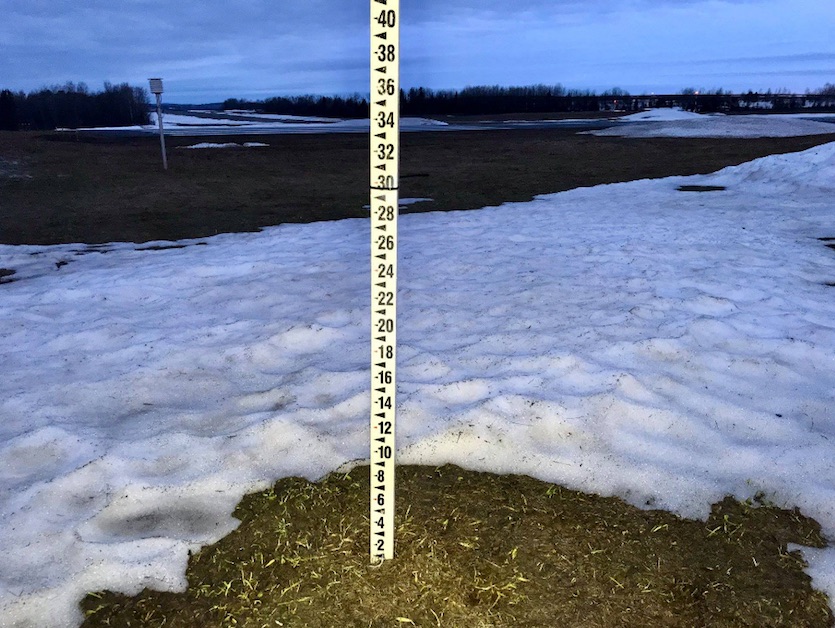
| Figure 1. On April 21, 2019, the last of the season’s epic snow accumulation in Caribou, Maine, finally disappeared after a record 163 consecutive days with an inch or more of snow on the ground, from November 10 until April 21. Pictured above is the snow stick used by the National Weather Service to measure the snow at its Caribou office. Image credit: NWS/Caribou. |
The Northeast and Mid-Atlantic
The relative absence of nor’easters this past winter resulted in a dearth of major snow events for the heavily populated I-95 corridor from Washington D.C. to Boston. Boston had an exceptionally snowless winter with only 27.4” accumulating, far short of its seasonal average of 43.8”, though a long way from its record low seasonal snowfall of just 9.0” in 1936-1937. Boston did have its slowest start on record for a snow season, receiving just 0.2” as of mid-January.
New York City came short of normal, but their most significant snow event occurred on November 15, when 6.4” fell. This was the earliest calendar day snowfall of 6” or greater on record for the city. Washington’s seasonal total was slightly above average.
Far northern New England had an exceptional snow season, as a seemingly never-ending stream of weak storms raked the region. Caribou, Maine received 59.8” of snowfall in January alone, just shy of its all-time record for any month of 59.9” set in December 1972. Caribou also endured 163 consecutive days with 1” or more of snow on the ground from November 10 to April 21, a new record for the site. The 164.7” seasonal total is Caribou’s third-greatest on record. That being said, Mt. Washington, New Hampshire, had picked up “only” 280.9” of snowfall as of April 26, just shy of its normal 281.2” seasonal total.
North Carolina and Virginia experienced an epic snow event on December 8-10. Asheville, NC, received its entire average seasonal total of 11.4”; Greensboro, NC had 12.0” on December 9its third-greatest calendar day total on record; and Roanoke, VA, picked up 15.0” (also on December 9), its greatest calendar day snowfall on record for the month of December and, like Greensboro, its third greatest for any month.
Here are the seasonal totals (as of April 26), the normals (for 1981-2010 POR), and the records for 10 cities in the mid-Atlantic and Northeast:
CITY 2018-2019 NORMAL RECORD
Caribou, ME 164.7” 109.0” 197.8” (2007-08)
Portland, ME 66.0” 61.8” 141.5” (1970-71)
Boston, MA 27.4” 43.8” 110.3” (2014-15)
Burlington, VT 103.6” 81.2” 145.4” (1970-71)
Buffalo, NY 118.7” 94.7” 199.4” (1976-77)
Pittsburgh, PA 36.6” 41.9” 80.0” (1950-51)
New York, NY 20.5” 25.1” 75.6” (1995-96)
Washington, DC 16.9” 14.5” 56.1” (2009-10)
Raleigh, NC 8.9” 5.9” 31.6” (1892-93)
Asheville, NC 11.4” 9.9” 48.2” (1968-69)
 |
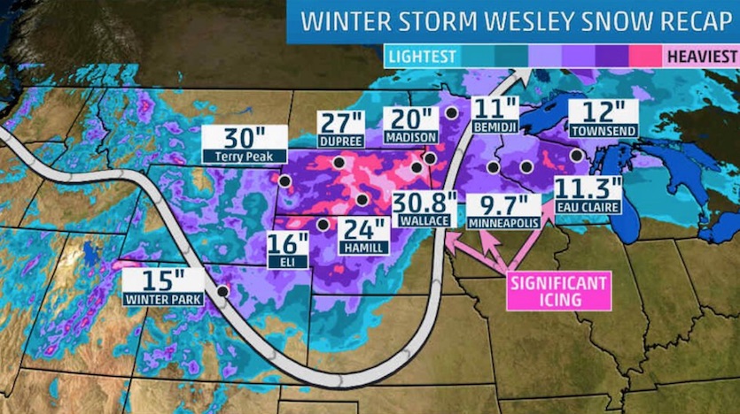
| Figure 2. Perhaps the most anomalous winter storm of the season was that which pounded the northern Plains on April 10-12. The blizzard (named Wesley by The Weather Channel) dropped up to 30” of snow at several locations in South Dakota. Watertown picked up 25”, its greatest single-storm snowfall on record. Image credit: weather.com, which provided a detailed recap of the storm in this post. |
Great Lakes, Midwest, and Plains
It was a very snowy winter for much of the Midwest and Plains. Eau Claire, Wisconsin, crushed its seasonal snowfall record with a 98.8” total (previous record was 89.3” in 1996-1997). Minneapolis logged its snowiest February on record with 39.0”. The city’s seasonal total of 77.1”, however, was far from its seasonal record of 98.6” established in 1983-1984, and actually an inch less than they received in the previous winter of 2017-2018.
A massive blizzard on April 10-12 dumped 25.0” of windblown snow on Watertown, South Dakota, its greatest single-storm snowfall on record. The snow pushed Watertown’s seasonal accumulation to an all-time record of 81.9” (previous record was 79.4” in 2010-2011). Aberdeen, South Dakota, experienced its second-snowiest winter on record with 81.1” (record is 110.8” in 1936-1937). The melting of the deep snowpack across Minnesota and the Dakotas resulted in major flooding along the rivers in the region.
The other notable storm of the season for the Plains states was the intense cyclone of March 13-14 that exploded over southeastern Colorado, bringing blizzard conditions to the region. This storm, however, was more notable for its high wind and very low barometric pressure than its snowfall. In fact, heavy rains atop snowpack in and near eastern Nebraska led to rapid melting and catastrophic floods, with more than 40 locations setting all-time-high river crests. For a detailed look at the storm see Jeff Masters’ post on the subject.
Chicago had a record late-season snowfall of 5.4” on April 14, a tie with the same amount on April 16, 1961, for its largest late-season calendar day snowfall. St. Louis received a trace of snow as well on April 14, followed by a daily record high of 86°F on the 16th!
Here are the seasonal totals (as of April 26), the normals, and the records for 10 cities in the Great Lakes, Midwest, and Plains:
CITY 2018-2019 NORMAL RECORD
Marquette, MI 221.7” 203.3” 319.8” (2001-02)
Detroit, MI 31.3” 42.7” 94.9” (2013-14)
Chicago, IL 47.0” 36.7” 89.7” (1978-79)
St. Louis, MO 24.2” 17.7” 67.6” (1911-12)
Minneapolis, MN 77.1” 50.6” 98.6” (1983-84)
Bismarck, ND 59.8” 51.2” 101.6” (1996-97)
Omaha, NE 52.7” 26.4” 67.5” (1911-12)
Kansas City, MO 29.1” 18.8” 67.0” (1911-12)
Oklahoma City, OK 5.8” 7.8” 25.2” (1947-48)
Rapid City, SD 68.6” 49.3” 90.2” (2008-09)
 |
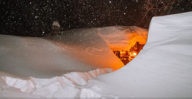
| Figure 3. Mammoth Ski Resort in the Sierra Nevada reported 132” (11 feet) of snowfall on the Upper Mountain and 89” at lodge level during the four-day period of February 2-5. Nearby June Mountain reportedly received 72” of snow in just a 24-hour period during the storm. If true, that would be close to the U.S. record for a 24-hour snowfall set at Silver Lake, Colorado on April 14-15, 1921 when 75.8” was measured. For the month of February, the resort claims that an incredible 548” of snow accumulated at its summit location (elevation 11,053’) and 207” at lodge level (elev. 9000’). Image credit: Mammoth Mountain Ski Area, via weather.com. |
The West
Tremendous snowfall in the central and northern Rockies as well as Sierra Nevada made for a superb skiing season but also resulted in a number of fatal avalanches as well. More than 500 avalanches were recorded in Colorado during the first ten days of March alone. Even some low-elevation sites, like Seattle, received unusually heavy accumulations.
Jackson, Wyoming, was buried under 55.9” of snow in February, just 0.1” shy of its all-time monthly record set in December 1969. The seasonal total for Jackson will never be known, since no measurements were made for three weeks in January as a result of the government shutdown. Local weather guru Jim Woodmencey estimates the total to have been between 90” and 100” (normal is 66.1”). The nearby Jackson Hole Mountain Ski Resort reported 505” at its Upper Mountain location (Rendezvous Bowl), including a monthly record of 193” in February.
The Sierra Nevada in California experienced its fourth-wettest (snowiest) winter season in modern records with an average of 60.6” of liquid equivalent as of April 20. Only the seasons of 2016-2017 (94.7”), 1982-1983 (88.5”), and 1997-1998 (82.4”) were wetter. Note that two of the three top seasons occurred during strong El Niño events, and this season was also likely influenced by El Nino conditions, albeit on the weak side.
Some ski resorts in the Sierra reported that their seasonal snow accumulations exceeded 600”, although snow depth reports from commercial ski resorts are not accepted as official measurements. Official snowfall statistics from Donner Summit or the Central Sierra Snow Laboratory will most likely not become available until sometime later this year.
Heavy snow in February resulted in an avalanche near Donner Summit that forced the closure of the rail line just west of Truckee for six days February 28-March 4, forcing Amtrak to halt service on its iconic California Zephyr line (Chicago to San Francisco). Almost 300 passengers were stranded in Reno, Nevada. Amtrak also suffered a major setback when snow and fallen trees closed the Coast Starlight line (Seattle-Los Angeles) south of Eugene near Oakridge on February 26, once again stranding hundreds of passengers.
February was the snowiest month of the season for virtually all the mountain locations in the West, including Flagstaff, Arizona, where 71.3” of its seasonal snowfall total of 117.2” occurred during the month. It was Flagstaff’s second-snowiest February on record (the record being 84.3” in 1901), and 35.9” of the 71.3” accumulated in just a single day on February 21, an all-time 24-hour (and calendar day) record for this very snowy site (POR since 1898).
Las Vegas picked up 0.8” of snowfall during the same storm and managed to see five days with snow during the month (trace amounts on February 10, 17, and 18, 0.5” on the 20th, and 0.3” on the 21st). The snowy stretch set a new record in Las Vegas for the most number of days with snowfall during any single month.
Here are the seasonal totals (as of April 26), the normals, and the records for 10 cities in the West:
CITY 2018-2019 NORMAL RECORD
Havre, MT 29.5” 38.5” 92.5” (2017-18)
Billings, MT 60.7” 55.0” 106.1” (2017-18)
Denver, CO 43.2” 53.8” 118.7” (1908-09)
Albuquerque, NM 9.5” 9.6” 37.4” (1972-73)
Boise, ID 18.0” 19.2” 50.0” (1916-17)
Salt Lake City, UT 46.3” 56.2” 117.3” (1951-52)
Seattle, WA 21.0” 6.8” 67.5” (1968-69)
Portland, OR 7.0” 4.3” 60.9” (1892-93)
Reno, NV 28.2” 21.8” 89.8” (2004-05)
Flagstaff, AZ 117.2” 103.6” 210.0” (1972-73)
Conclusion
Overall, it was a fairly normal snow season (punctuated by some extreme snow events) for the majority of the contiguous U.S. Only northern Maine, the Upper Midwest, northern Plains, and the high elevations of the Rocky Mountains and Sierra Nevada saw much above average snowfall. Most winters see one place or the other break a snowfall record of some type, and this winter was no exception. Widespread colder-than-normal temperatures in late winter and early spring, especially in February and March, may have added to the perception of a snowy winter, allowing the snow that did fall to stick around for long periods over large areas.
This being said, the snow season of 2018-19 seemed to be in no hurry to end, as measurable snow was in the forecast for the final weekend of April for parts of the upper Midwest. There have been many extraordinary late-season snowfalls in late April and May (and even June). You can read about some of these in a post I wrote back in April 2011.
Christopher C. Burt
Weather Historian


