| Above: MODIS visible satellite image of a tropical wave newly emerged from the coast of Africa on Monday morning, August 27, 2018. Image credit: NASA Worldview. |
It’s late August, the traditional beginning of the peak part of the Atlantic hurricane season. Historically, over 60% of all Atlantic hurricanes and 75% of all Atlantic major hurricanes have formed between August 20 and October 10. Over the next six weeks, we will see a steady parade of strong tropical waves emerging from the coast of Africa, and some of these waves will be capable of acting as the seeds for the most dangerous type of Atlantic hurricanes--the Cape Verde storms.

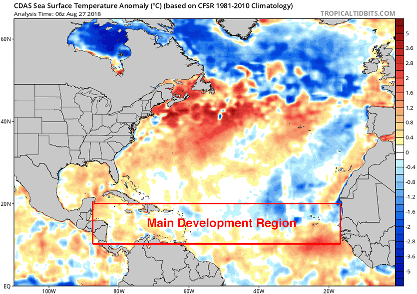
The Cape Verde storm season has been slow to start this year, though, thanks to high wind shear as well as sea surface temperatures (SSTs) in the tropical Atlantic that have been among the coolest we’ve seen since the mid-1990s. However, SSTs have rebounded to near-average levels over the past few weeks, thanks to a relaxation of the strong easterly trade winds that had been acting to stir up and cool the waters. Wind shear is still higher than average over much of the tropical Atlantic, but we could nevertheless see the development of our first Cape Verde-type system late this week. The Madden-Julian Oscillation (MJO), a pattern of increased thunderstorm activity near the Equator that moves around the globe in 30 - 60 days, is currently weak and disorganized, and is in a configuration that favors weakly sinking air and suppressed tropical cyclone activity in the Atlantic, but rising air and increased tropical cyclone activity in the Pacific. The MJO may become more supportive of Atlantic tropical cyclone activity by next week, though.The next name on the Atlantic list of storms is Florence.
 |
| Figure 1. Departure of SST from average for August 27, 2018. SSTs were near average in the hurricane Main Development Region (MDR), the tropical Atlantic from Central America to the coast of Africa. Image credit: Levi Cowan, tropicaltidbits.com. |
Two African waves to watch
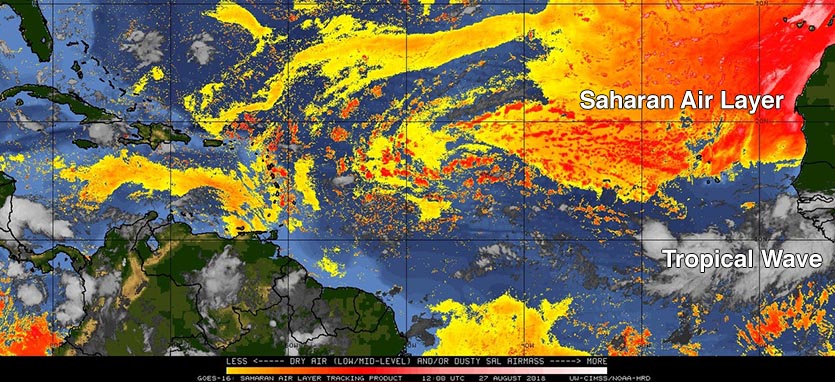
This week, we will have two African waves capable of developing into tropical depressions to watch. The first of these waves emerged from the coast of Africa on Sunday. The wave was generating a large amount of heavy thunderstorms on Monday morning, from a few hundred miles south of the Cabo Verde Islands to the coast of Africa, but did not have much spin. Favoring development were warm sea surface temperatures (SSTs) near 29°C (82°F), and the fact that the dry air and dust of the Saharan Air Layer (SAL) lay well to the north of the tropical wave. However, high wind shear of 15 – 25 knots was unfavorable for development, and the wave is expected to continue to battle high shear this week as it moves westward at 10 – 15 mph. None of the operational versions of our top three models for predicting tropical cyclone genesis--the European, GFS, and UKMET models--predicted in their 0Z Monday runs that this wave would develop into a tropical depression, and the National Hurricane Center (NHC) did not mention it in their 8 am EDT Monday Tropical Weather Outlook.
 |
| Figure 2. Saharan Air Layer (SAL) satellite analysis from 8 am EDT Monday, August 27, 2018. The dry air and dust of the SAL (orange colors) was located over the tropical Atlantic to the north of a vigorous tropical wave that had emerged from the coast of Africa on Sunday. Image credit: University of Wisconsin CIMSS. |
Thursday’s tropical wave: the one to watch?
According to the 0Z Monday runs of the GFS and European models and their ensembles, as well as the UKMET model, the best chance for an African wave to develop this week will occur from a tropical wave expected to emerge from the coast of Africa on Thursday night or Friday morning. Wind shear over the eastern tropical Atlantic is predicted to be lower by this weekend, and all of the models show some development of this wave in the waters near the Cabo Verde Islands off the coast of Africa, as early as Saturday.
Resilient Lane not long for this world
In the Central Pacific, Tropical Storm Lane continues to battle against high wind shear of 40 knots, and is expected to dissipate by Monday night, according to the Central Pacific Hurricane Center. See Bob Henson’s post on Saturday for a summary of Lane’s remarkable records. The highest rainfall amount from Lane received thus far, as reported by weather.com, was at Mountain View, located in the higher elevations of the Big Island, which received 51.53 inches of rain from noon Wednesday, August 22, to 4 am Sunday, August 26 local time (HST).
The #USCRN station's rain gauge in Hilo, HI was drained twice throughout the 4-day event totaling 47.59" or ~4ft of rain due to hurricane #Lane. Peak precipitation intensity was 8.6mm/5min or ~4.06" per hour. The 4-day rain total according to #NOAA Atlas-14 was a 500 year event. pic.twitter.com/zwHWEl2aNw
— Ronald D Leeper (@rleeperd) August 27, 2018
The Eastern Pacific also has Tropical Storm Miriam, which is expected to intensify into that basin’s next hurricane by Monday night. Miriam is not expected to threaten any land areas. Of more concern in the Eastern Pacific may be Invest 90E, which is likely to become a Tropical Storm Norman late this week. This system may be a long-range threat to Hawaii by late next week.
TD 25W forms in Northwest Pacific
In the Northwest Pacific, Tropical Depression 25W has formed, and appears destined to become the season’s next typhoon. The depression is expected to intensify into a major typhoon by Thursday, when it will be passing about 400 miles northeast of Guam in the Northern Mariana Islands. Both the GFS and European models predict that TD 25W could threaten Japan by the middle of next week. However, the models have little skill at making track forecasts so far in the future. It would not be a surprise if this system became a super typhoon with 150+ mph winds by this weekend.


