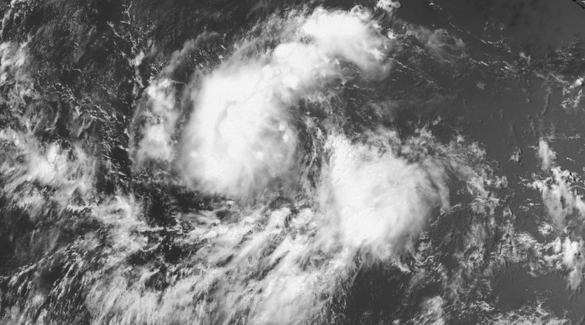
| Above: Infrared image of a strong tropical wave passing over the Lesser Antilles at 1920Z (3:20 pm EDT) Sunday, July 28, 2019. Showers and thunderstorms associated with the wave will be heading toward Puerto Rico (top left) and other parts of the Greater Antilles over the next several days. Image credit: NASA/MSFC Earth Science Branch. |
Hurricane season has kicked into gear this weekend, just as we’re about to enter the climatological peak period of activity from August through October. As of Sunday afternoon, we have Tropical Storm Erick intensifying in the Northeast Pacific, with a new depression following close behind. Both of these systems could pass near Hawaii in the next 6 to 10 days. Meanwhile, a strong tropical wave now affecting the Lesser Antilles will be arcing toward the Florida Straits later this week. Another strong wave is moving off the African coast, heralding the advent of Cape Verde season.
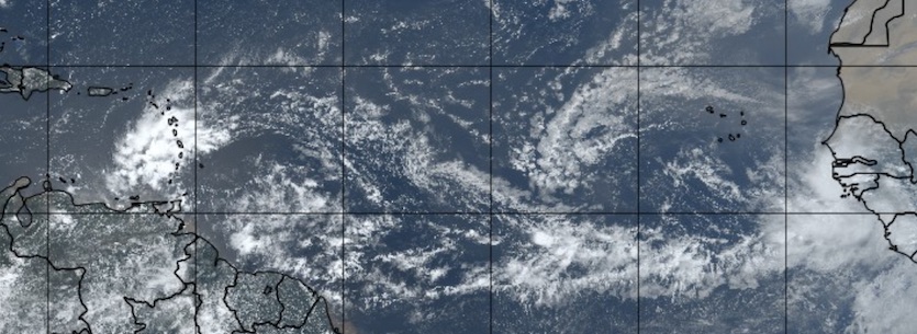 |
| Figure 1. This natural-color satellite image from 1535Z (11:35 am EDT) Sunday, July 28, 2019, shows the active wave train across the tropical Atlantic, as well as the dusty Saharan air layer in the eastern Atlantic just to the north of the wave train. Image credit: tropicaltidbits.com. |
Invest 95L brings squally weather to the Lesser Antilles
Thunderstorms were expanding across the far eastern Caribbean on Sunday in conjunction with a strong tropical wave dubbed Invest 95L. This wave has managed to fight off the influence of wind shear and dry Saharan air, maintaining integrity along its westward trek through the deep Atlantic tropics. The wave likely benefited from rising motion at upper levels provided by a large-scale feature called a convectively coupled Kelvin wave (CCKW) moving across the region, as noted by Philippe Papin (Naval Research Laboratory) on Friday.
The AEW wave train has really gotten a convective boost from the convectively coupled kelvin wave moving overhead currently (map from @MJVentrice).
— Philippe Papin (@pppapin) July 27, 2019
Would not shock me to see a brief window for TC genesis in MDR over the next 24-48 hrs from one of the waves in the MDR. https://t.co/Te3trPdcVW pic.twitter.com/ZrSdm7gHRC
The expansion of thunderstorms on Sunday over and near the Lesser Antilles, and the associated upper outflow, indicate the vigor of 95L. Strong upper-level divergence was evident atop 95L Sunday morning, a sign of the strengthening outflow. ASCAT scatterometer data at midday Sunday showed north winds of 25-30 knots on the west side of the wave, with southerly winds well to the south. No closed circulation was evident. It wouldn’t take much more organization for 95L to close off a surface center and become a tropical depression, but interaction with the islands will likely quash that potential.
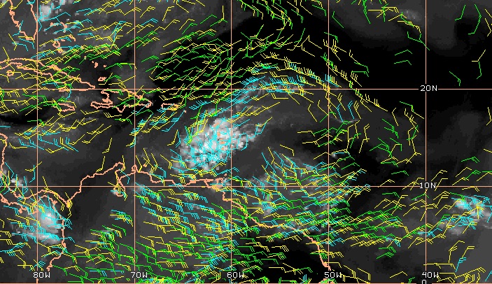 |
| Figure 2. Upper-level winds at three levels show anticyclonic flow near and to the east of Invest 95L as of 11 am EDT Sunday, July 28, 2019, indicating an upper-level high near the system that would favor development. The levels shown are 100-250 mb (blue), 251-350 mb (yellow), and 351-500 mb (green). Image credit: CIMSS/SSEC/UW-Madison. |
Over the next couple of days, 95L will be moving northwest across the eastern Caribbean—a region so notorious for strong wind shear and dry air, especially early in the season, that it’s sometimes called a hurricane graveyard. At first, a small upper ridge building over the eastern Caribbean could give 95L enough support to maintain itself over this hostile region. As the wave approaches the Greater Antilles around midweek, it will encounter strong westerly shear, and interaction with the larger islands will disrupt any circulation. Heavy thunderstorms can be expected to spread westward from Puerto Rico across Hispaniola toward Cuba, and some localized flash flooding will be possible.
On its continued northwest path, 95L is projected to move over the very warm waters of the Florida Straits late this week at the same time a large upper ridge is projected to sharpen there. Together, these may give 95L its best shot at intensification. The 2 pm EDT Sunday tropical weather outlook from the National Hurricane Center (NHC) gives 95L a 10% chance of becoming at least a tropical depression by Tuesday, and a 20% chance by Friday.
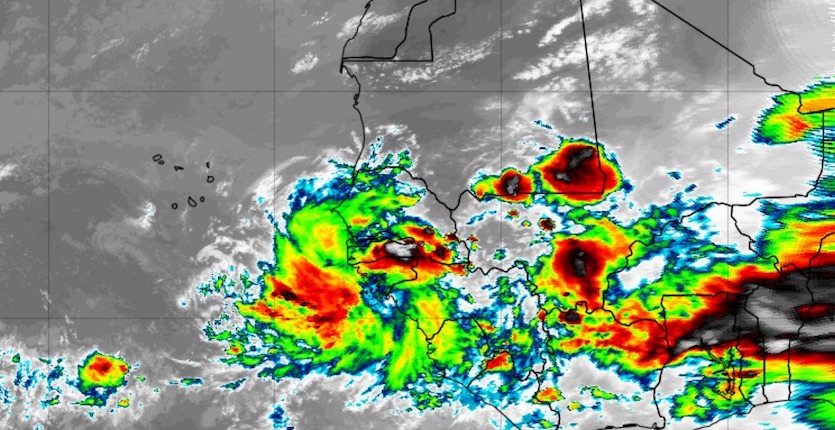 |
| Figure 3. Thunderstorms associated with a strong tropical wave moving off Africa can be seen in this infrared-wavelength satellite image from 1915Z (3:15 pm EDT) Sunday, July 28, 2019. Another strong wave is heading westward from central Africa (far right). Image credit: tropicaltidbits.com. |
Another wave to watch in the eastern Atlantic
Late July is usually a bit too soon to worry about Cape Verde-type waves developing in the eastern Atlantic, but we have a potential candidate on our hands. A very potent easterly wave, with plenty of spin already evident on satellite imagery, is now moving off the African coast into the deep Northeast Atlantic tropics, centered near latitude 10°N.
About 10% of GFS ensemble members from 0Z Sunday, and about 20% of European ensemble members, develop this wave into a tropical cyclone over the central Atlantic toward the latter half of this week. If it develops, this system could affect the Lesser Antilles about a week from now.
 |
| Figure 4. Infrared image of Tropical Storm Erick (left) and Tropical Depression 7-E (right) at 1935Z (3:35 pm EDT) Sunday, July 28, 2019. Image credit: tropicaltidbits.com. |
Tropical Storm Erick gaining strength in the East Pacific
Christened on Saturday, Tropical Storm Erick is slowly organizing about 1800 miles east-southeast of Hilo, Hawaii. Erick’s top sustained winds were only 40 mph as of 11 am EDT Sunday, but Erick’s envelope of showers and thunderstorms was expanding. Strengthening is likely over the next several days as Erick moves west to west-northwest, driven by steady, well-established steering currents in the upper atmosphere. Wind shear is predicted to be light (less than 10 knots) through Tuesday and moderate (10-15 knots) on Wednesday and Thursday, and sea surface temperatures along Erick’s track will be around 28°C (82°F). These factors all point toward Erick intensifying. Moderately dry mid-level air (relative humidity 55-60%) is the main countervailing factor.
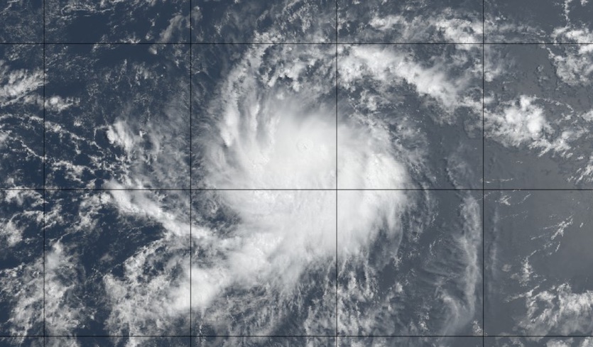 |
| Figure 5. Natural-color image of Tropical Storm Erick at 1845Z (2:45 pm EDT) Sunday, July 28, 2019. Image credit: tropicaltidbits.com. |
The SHIPS intensity model on Sunday morning gave Erick a 36% chance of rapid intensification—gaining 25 knots of strength in 24 hours, which would bring it near hurricane strength early Monday. NHC predicts that Erick will become a hurricane by late Monday and peak at Category 2 strength by Wednesday. The 12Z Sunday runs of the HWRF and HMON high-resolution models agree on the diagnosis that Erick will peak at Category 2 strength. I wouldn’t be surprised to see Erick intensify even more quickly and dramatically, given its current health, the favorable conditions ahead, and the compact size of its core. Update (12:30 am EDT Monday): In its 11 pm EDT Sunday forecast discussion, NHC increased their prediction of Erick's peak strength to Category 3 (115 mph) and said, "This is one of these rare forecasts where it is difficult to find a reason not to predict rapid intensification."
Erick will likely embark on a slow weakening trend later this week, as wind shear increases and the storm moves toward slightly cooler but still-warm-enough waters of 26-27°C (79-82°F), which are up to 1°C (1.8°F) warmer than average for this time of year. Current long-range models show Erick passing well south of Hawaii around Saturday, though the track forecast will bear watching. At a minimum, Erick will send high surf toward Hawaii later this week, and a period of squally weather is possible on its closest approach.
 |
| Figure 6. Visible satellite image of developing Tropical Depression 7-E in the eastern Pacific as of 1930Z (3:30 pm EDT) Sunday, July 28, 2019. Image credit: NASA/MSFC Earth Science Branch. |
TD 7E on track to become Flossie
A tropical depression following in Erick’s wake will likely become Tropical Storm Flossie late Sunday or early Monday. Centered about 600 miles south-southwest of Manzanillo, Mexico, TD 7E was hustling west-northwest at 21 mph with top winds of 35 mph as of 11 am EDT Sunday. Thunderstorms were focused in a large band on the north side of TD 7E at midday Sunday, but the depression as a whole was becoming more organized.
Conditions ahead of TD 7E are quite similar to those ahead of Erick, except that TD 7E will benefit from a moister mid-level atmosphere (relative humidity 70-75%). Thus, we can expect at least steady intensification, which could make TD 7E a hurricane as soon as Tuesday. TD 7E’s track by midweek should be running parallel to Erick’s but about 100-150 miles to the north, which may be far enough to reduce any negative impact from cooler waters churned up by Erick. The 12Z Sunday run of the HWRF model suggests that Category 3 strength is possible by Wednesday; other models are a bit more conservative. Update (12:30 am EDT Monday): According to the 11 pm EDT Sunday forecast discussion from NHC, 7E will be in a "nearly ideal environment for strengthening" for up to three days, with a chance of rapid intensification. The center adds: "It should be noted that once rapid intensification starts, the system could strengthen faster than currently forecast and reach category 3 or higher intensity."
Longer-range models—including the 12Z runs of the GFS and European models—have been agreeing that TD 7E could pass over or near Hawaii in about 8-9 days, but a forecast that far out is subject to large errors. As is common with systems approaching Hawaii, TD 7E would almost certainly weaken before reaching the vicinity of the islands.


