| Above: Natural-color satellite image of the Atlantic tropics and subtropics at 1755Z (1:55 pm EDT) Friday, August 2, 2019. A cluster of showers and thunderstorms north of the Lesser Antilles was associated with a tropical wave not expected to develop. A less dramatic-looking wave to the east could become a tropical depression this weekend or early next week. Image credit: tropicaltidbits.com. |
If you were betting on one or more named storms to pop up in the Atlantic this week, you may be counting your losses. So far, none in a parade of energetic tropical waves has managed to develop into a full-fledged tropical cyclone, although one may still emerge near the Leeward Islands in the next several days. Meanwhile, Hawaii is getting mostly minor impacts from a pair of tropical storms, and Japan may be dealing with a typhoon next week (and perhaps another to follow).
Conditions in the Atlantic have been marginally supportive for tropical cyclones the last few days, thanks in part to rising motion fostered by the leading edge of a convectively coupled Kelvin wave (CCKW). Now, though, the back side of the CCKW is bringing downward motion that will help inhibit development for at least a few days.
The suppressed Kelvin wave that is shutting down convection over the Atlantic's main development region is predicted to bring an unfavorable environment for developing tropical cyclones. Expecting things could stay quiet until Aug 18, when another CC Kelvin wave moves in. pic.twitter.com/YdJSWh2BYz
— Michael Ventrice (@MJVentrice) August 2, 2019
The only area of interest in the Atlantic spotlighted by the National Hurricane Center in its 2 pm EDT tropical weather outlook is Invest 96L, located in the central Atlantic a few hundred miles east of the Lesser Antilles. 96L will be moving into an area of moderate wind shear (10 – 20 knots) and increasingly warm sea surface temperatures (27-28°C or 81-82°F), so if the wave can fend off dry mid-level air and form a closed center, it has some chance of developing. Wind shear will increase markedly as the wave moves toward the northern Leeward Islands, however, so any development may be short-lived.
About half of European and GFS model ensemble members from Friday morning generate a depression from 96L east of the Leewards. Only about 20% of the ensemble members maintain 96L as a tropical cyclone beyond that point, with great uncertainty over where such a system might move. NHC gives 96L a 20% chance of development through Sunday and a 40% chance through Wednesday.
With model support consistently much lower for development of 96L since yesterday, and its continuing elongated structure, the risk of a tropical storm approaching the Antilles is decreasing. However, it is not zero, and heavy weather could occur early next week, regardless. pic.twitter.com/IKiVjYAqbl
— Levi Cowan (@TropicalTidbits) August 2, 2019
Erick and Flossie losing interest in Hawaii
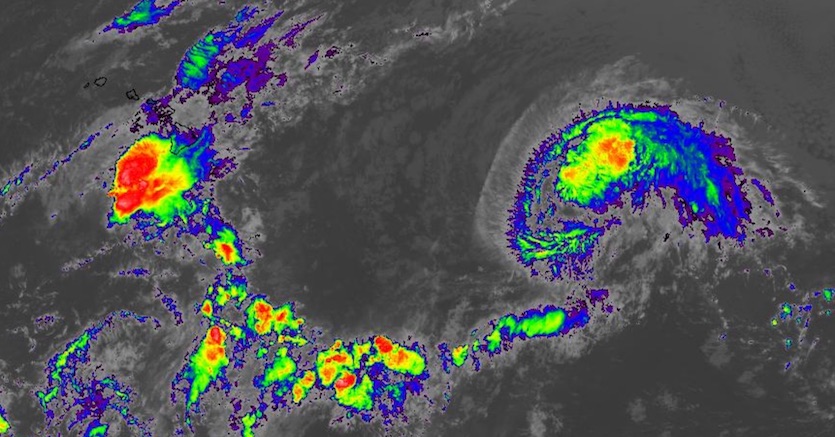
Just two days after its peak as a Category 4 hurricane, weakening Tropical Storm Erick is heading away from Hawaii, having passed about 170 miles south of the Big Island on Thursday night. Erick was already below hurricane strength by that point, and impacts on Hawaii have been minimal apart from high surf, gusty winds, localized heavy rain, and a couple of mudslides, according to Hawaii News Now. Strong wind shear—a frequent bane to hurricanes near Hawaii—will continue to plague Erick as it pulls west-northwest. Erick could become a remnant low as soon as Sunday, according to the Central Pacific Hurricane Center.
 |
| Figure 1. Infrared image of tropical storms Erick (left) and Flossie (right), linked by a belt of weak thunderstorms, at 2130Z (5:30 pm EDT) Friday, August 2, 2019. Image credit: NASA/MSFC Earth Science Branch. |
Likewise, Tropical Storm Flossie should go easy on Hawaii. Located about 1000 miles east of Hilo at 5 pm EDT Friday, Flossie is moving west-northwest with top winds of 65 mph. Models are in strong agreement that recurvature toward the north will kick in as Flossie passes just north of Hawaii around Monday. Such a track would keep Hawaii on Flossie’s weaker left-hand side. Much like Erick, Flossie is already suffering the impacts of wind shear, and sea surface temperatures (SSTs) of 26-27°C (79-81°F) are only minimally supportive, so the storm should weaken throughout the weekend. Swells and high surf may be the only impacts from Flossie on Hawaii.
 |
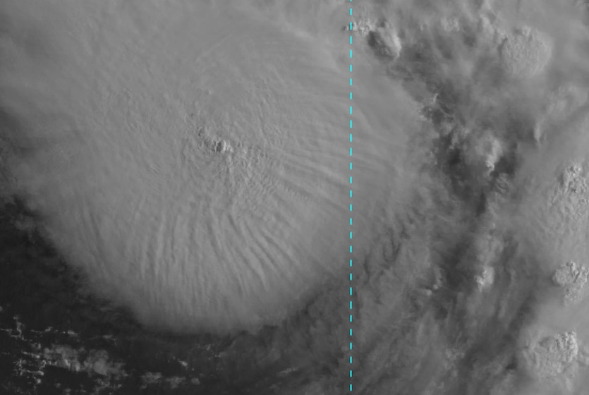
| Figure 2. Himiwari-8 visible satellite imagery of Tropical Storm Francisco at 2100Z (5 pm EDT) Friday, August 2, 2019. Image credit: RAMMB/CIRA/CSU.= |
Japan watches what could be its first typhoon of 2019
Farther west, Tropical Storm Francisco may become the Northwest Pacific’s first typhoon in more than five months. The year’s only typhoon so far was a humdinger—Wupit, the only Category 5 super typhoon on record in February—but otherwise, it’s been an uncommonly quiet typhoon season. The amount of accumulated cyclone energy in the Northwest Pacific was only a little over half of average for the date as of August 2, according to data compiled by CSU.
Satellite imagery showed that Francisco was developing a strong core of convection (showers and thunderstorms) on Friday night local time. The Joint Typhoon Warning Center predicted that Francisco would intensify to the equivalent of Category 1 strength before reaching the southernmost of Japan’s large islands, Kyushu, around Tuesday local time. The storm might hit other parts of southern Japan depending on the exact trajectory it takes. Another system in the Northwest Pacific, Invest 94W, could become a typhoon next week and might end up posing a threat to Japan as it heads mainly north and northwest.
Japan is accustomed to typhoons. In a typical year, three typhoons strike Japan, according to data from the Japan Meteorological Agency analyzed by nippon.com. Landfalls are most common in August, but the most destructive typhoons tend to be in September, the report noted.


