| Above: Infrared image of Tropical Storm Imelda along the Texas coast at 1812Z (2:12 pm EDT) Tuesday, September 17, 2018. Image credit: tropicaltidbits.com. |
Mid-September is behaving very much in line with the climatological peak of hurricane season in the Atlantic, as the National Hurricane Center launched advisories on several new systems in the space of just two hours at midday Tuesday. Of most immediate concern to the United States is Tropical Storm Imelda, a newly designated system along the central Texas coast that could bring several days of flooding rains to the Houston area. Update: NHC issued its last advisory on Imelda at 11 pm EDT Tuesday, as the storm—by that point a tropical depression—was gradually moving inland and will soon become a remnant low. The heavy rain threat from Imelda continues, as detailed below.
Meanwhile, a hurricane watch and a tropical storm warning have been hoisted for Bermuda ahead of Hurricane Humberto, now a Category 2 storm with an expansive field of damaging winds. Humberto will move near or just northwest of Bermuda late Wednesday or early Thursday. Update: NHC upgraded Humberto to Category 3 strength at 11 pm Tuesday, with top sustained winds of 115 mph.
On top of all this, the system known as 97L became Tropical Depression 10 on Tuesday morning, and it’s likely to become a hurricane before it approaches the Lesser Antilles late this week.
Not to be outdone, the Eastern Pacific has one hurricane, one tropical storm, and one tropical depression, plus another system that could develop later this week.
Ok September 2019- I give. Storms forming all over the place- this is uncommon even for the peak of the season to have so many TCs and close-to-TC disturbances. pic.twitter.com/qDNz4Q1LSx
— Eric Blake (@EricBlake12) September 17, 2019
Imelda to bring flooding rains to southeast Texas
In an exceptionally busy morning, NHC started advisories on Tropical Depression 11 just two hours after Tropical Depression 10 (more on that system below), then quickly upgraded TD 11 to Imelda just 45 minutes later. As of 1:45 PM EDT Tuesday, the center of Imelda was near Freeport, Texas, about 40 miles southwest of Galveston. Imelda made landfall at 2:30 PM EDT near Freeport with top sustained winds of 40 mph, according to NHC. A large cluster of convection was mostly offshore to the east of Imelda’s center, with some thunderstorms pushing onshore into southeast Texas.
TD 11 will move inland shortly over Brazoria County #houwx #txwx pic.twitter.com/b1Glj9jBiN
— Jeff Lindner (@JeffLindner1) September 17, 2019
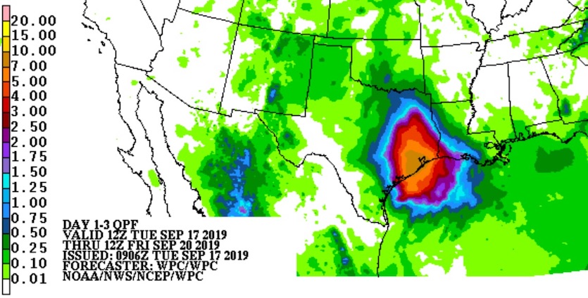
A tropical storm warning is in effect from Sargent to Port Bolivar, Texas. The main threat from Imelda will be heavy rains and flooding, as the system will only gradually work its way into central Texas over the next several days. More than 2” of rain fell between Houston and Galveston overnight Monday night. Rainfall is expected to remain focused just east of Imelda’s center, which will put the massive, flood-prone Houston metropolitan area at risk of flooding episodes over the next several days. A moderate risk of excessive rains leading to flash floods is in effect for a patch of southeast Texas in and near the Houston area from Tuesday through Thursday.
 |
| Figure 1. Rainfall forecast for the three days from 8 am EDT Tuesday, September 17, 2019, through Friday, September 20, 2019. Image credit: NOAA/NWS/WPC. |
Some of the high-resolution models that successfully conveyed the risk of torrential rains from Hurricane Harvey as it lingered near the Texas coast are again warning of a significant threat from Imelda. Note that a Harvey-scale event is not expected with Imelda. However, keep in mind that an event considerably weaker than Harvey could still produce major flood-related complications across the Houston area.
As Imelda inches its way northward, the heaviest rainfall is likely to shift from the coastal zone between Houston and Corpus Christi on Tuesday toward the greater Houston area on Wednesday, although torrential rains and flash floods will be possible across the region at any point during this event. The 12Z Tuesday run of the HRRR model indicates that more than 10” of rain could fall southwest of the Houston area on Tuesday night. The 3-km NAM model suggests that 10 – 20" could accumulate across large parts of the metro area by Thursday, with much of that falling on Wednesday night.
 |
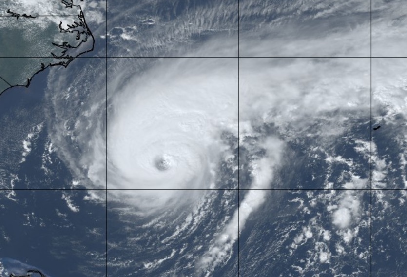
| Figure 2. GeoColor image of Hurricane Humberto at 1807Z (2:07 pm EDT) Tuesday, September 17, 2019. Image credit: tropicaltidbits.com. |
Humberto continues to strengthen as it heads toward Bermuda
Hurricane Hunters found flight-level winds of 110 mph on Tuesday morning in Hurricane Humberto, prompting the National Hurricane Center to upgrade Humberto to a Category 2 storm with top surface winds of 100 mph. As of 11 am EDT, Humberto was just over 500 miles west of Bermuda, moving east-northeast at 8 mph. Humberto’s central pressure was 961 mb, which would typically correspond to stronger peak surface winds. However, the pressure gradient driving the winds was spread out over a larger area than usual. Hurricane-force winds now extend up to 50 nautical miles (57 miles) southeast of Humberto’s center, with tropical-storm-force winds extending up to 150 nm (172 mi). This zone of high winds will affect Bermuda even though Humberto’s center and eyewall will likely pass well northwest of the territory. The latest NHC forecast brings Humberto’s center to within about 60-70 miles northwest of Bermuda. Large swells will affect the island as well as much of the Southeast U.S. coast.
The 0Z ensemble runs of the GFS and European models agree that Humberto will continue out to sea later next week, with a slight northward jog on Thursday and Friday. As it passes over unusually warm waters for its latitude and gets a boost from upper-level jet dynamics, Humberto could reach major hurricane status on Wednesday, as consistently predicted by the HWRF model, one of the best tools for intensity prediction in the 24- to 48-hour range.
 |
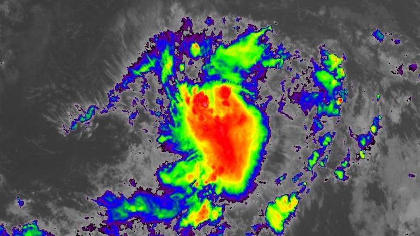
| Figure 3. Infrared image of TD 10 at 1810Z (2:10 pm EDT) Tuesday, September 17, 2019. Image credit: NASA/MSFC Earth Science Branch. |
Tropical Depression Ten forms east of the Leeward Islands
NHC launched advisories on Tropical Depression Ten (formerly Invest 97L) at 11 am EDT Tuesday. TD 10 is a fairly classic Cape Verde-type system, gradually organizing as it cruises through the Main Development Region of the deep Atlantic tropics between the Caribbean and Africa. TD 10 already has a robust core of convection (showers and thunderstorms) and excellent upper-level outflow, so it will likely become a tropical storm later Tuesday or early Wednesday. The next name on the Atlantic list is Jerry.
Located about 1165 miles east-southeast of the Leeward Islands, TD 10 will continue heading west-northwest over the next several days as it gathers strength. Wind shear will be light to moderate (around 10 knots), which should allow the depression to wall off a pocket of moisture and fend off moderately dry air at mid-levels (relative humidity around 50%). Sea surface temperatures of 28-29°C (82-84°F) are more than warm enough for development, and TD 10 may also encounter one or more pockets of elevated oceanic heat content. The 12Z Tuesday run of the SHIPS model gives TD 10 a relatively high one-in-three chance of approaching major hurricane strength by Friday, when the system will be nearing the northern Leeward Islands.
Looking further out, the 0Z Tuesday GFS and European ensemble runs suggest that TD 10 is likely to recurve before threatening the U.S. East Coast. All but about 5% of GFS ensemble members and 10-20% of Euro ensemble members show such a recurvature. It’s too soon to count on such an outcome, though, as steering currents could easily change between now and then.
Meanwhile, a new tropical wave that will come off the coast of Africa later this week has a 20 percent chance of developing into at least a tropical depression between about Thursday and Sunday, according to NHC’s 2 pm EDT Tuesday Tropical Weather Outlook.
 |
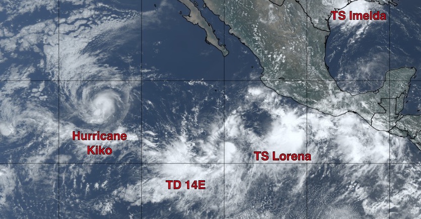
| Figure 4. From left to right, Hurricane Kiko, Tropical Depression 14E, Tropical Storm Lorena, and Tropical Storm Imelda (upper right, near the Texas coast) at 1815Z (2:15 pm EDT) Tuesday, September 17, 2019. Image credit: tropicaltidbits.com. |
Eastern Pacific in a nutshell
Tropical storm watches are up from Zihuatanejo to Cabo Corrientes, Mexico, ahead of Tropical Storm Lorena, which developed on Tuesday morning more than 200 miles south of Acapulco. Lorena is likely to remain below hurricane strength, due mainly to wind shear of 15-20 knots, as it moves on a steady northwest track that’s expected to bring it fairly close to the Mexican coast from Wednesday through Thursday. The main problem from Lorena will be 3-6” rains along and near the coast, with localized totals of 10” or more, bringing a threat of flash floods and mudslides.
About 500 miles west of Lorena, newly designated Tropical Depression 14E is expected to become a tropical storm by tonight and a hurricane by Thursday, although interactions with Lorena may hinder its strengthening. Given the short distance between them, TD 14E and Lorena may engage in a Fujiwhara dance, rotating around each other, as depicted in several runs of the GFS model. Such interaction would complicate the forecast of both systems, so we’ll have to see how things sort out. Update: TD 14E became Tropical Storm Mario at 5 pm EDT Tuesday. Following Imelda and Lorena, Mario became the third storm to be assigned a name by NHC in a six-hour period.
Even further west, Hurricane Kiko may go through multiple rounds of weakening and strengthening over the next several days as it carries out an unusual snake-like westward path well away from land.


