| Above: Visible GOES-16 satellite image of Potential Tropical Cyclone 9 (PTC 9) over The Bahamas at 10:40 am EDT September 13, 2019. Image credit: NOAA/RAMMB. |
Long-suffering residents of the Northwest Bahamas—still coming to grips with the human and physical toll from catastrophic Hurricane Dorian—now face a tropical storm warning for a system predicted to develop into a tropical storm by Saturday. Update: A disturbance in the Southeast Bahamas, designated Potential Tropical Cyclone 9 (PTC 9) by the National Hurricane Center on Thursday, became Tropical Depression 9 with a 5 pm advisory from NHC. It is predicted to become Tropical Storm Humberto tonight or Saturday. The tropical storm warning for the Northwest Bahamas includes all areas except Andros Island. Tropical storm watches are up for a portion of the central east coast of Florida, as well. There is little change to the overall prognosis outlined below.
PTC 9 was bringing heavy rain showers and gusty winds to the east coast of Florida and The Bahamas on Friday morning, including the islands of the Northwest Bahamas hardest-hit by Hurricane Dorian earlier this month. Settlement Point, on the western end of Grand Bahama Island, which was devastated by Dorian, recorded sustained winds of 28 mph, gusting to 32 mph, at 2 am EDT Friday morning. As of 11 am EDT Friday, the top surface winds found by the Hurricane Hunters in PTC 9 were just 25 mph, though the plane had not sampled the entire circulation yet. Update: The Hurricane Hunters found a weak center of circulation near the heaviest showers and thunderstorms (convection), prompting the upgrade to a tropical depression.
Satellite loops and data from the Bahamas radar and the Hurricane Hunters on Friday morning showed that PTC 9 did not have a well-defined surface circulation, but heavy thunderstorm activity was steadily growing in intensity, areal coverage, and organization. The system was tangled up with an upper-level trough off the west coast of Florida, and the upper-level winds associated with this trough were bringing dry air and moderate wind shear of 15 – 20 knots to the west side of PTC 9, inhibiting development. Sea surface temperatures (SSTs) in The Bahamas, though depressed by the passage of Hurricane Dorian, were still plenty warm for development--near 29°C (84°F).
The main threat from PTC 9 to the Northwest Bahamas is heavy rain and perhaps tropical-storm-force winds, as the system will have little time to intensify further before reaching the islands. Widespread rainfall of 2” to 4” is expected, with pockets of up to 6” possible. These conditions will hamper post-Dorian relief efforts, but will provide much-needed rain to the cisterns used to provide fresh water to the islands.
Recon already found the little surface center near Cat Island, but we may see an attempt at relocating beneath the mid-level center to the east. Recon winds do suggest at least an extension towards that location. #PTC9 pic.twitter.com/7Vdq3HiKbd
— Levi Cowan (@TropicalTidbits) September 13, 2019
Forecast for PTC 9
The forecast models for PTC 9 have come into better agreement than on Thursday. The consensus is now that PTC will not cross into the Gulf of Mexico; fewer than 10% of the 70+ members of the 0Z Friday GFS and European model ensemble forecasts now have that solution. Instead, the models now agree upon a slow motion to the northwest bringing PTC 9 very close to the northeast coast of Florida on Saturday. By Sunday, a trough of low pressure to the north of PTC 9 is expected to pull the storm to the northeast, putting it well to the southeast of North Carolina by the middle of next week. At this time, it is very uncertain how much rainfall the Carolinas might get from PTC 9.
The main factor keeping PTC 9 in check is strong southerly wind shear and dry air from an upper-level low in the eastern Gulf of Mexico. Forecast models show this low retreating toward the western Gulf over the next couple of days, with upper-level high pressure building over PTC 9. This shift will make it easier for PTC 9 to strengthen over the weekend, assuming that the disturbance can consolidate around a well-defined surface low.
The 12Z Friday SHIPS model predicted that wind shear would drop to about 10 knots on Saturday and Sunday from the current 15 - 20 knots, then rise to the high range, 15 – 30 knots, beginning on Monday afternoon. The high wind shear expected early next week is a key reason why less than 10% of the 70+ members of the 0Z GFS and European model ensemble forecasts predicted that PTC 9 would eventually become a hurricane.
Despite the passage of Hurricane Dorian, which churned up vast amounts of water around the Northwest Bahamas, PTC 9 will have ample oceanic fuel. Sea surface temperatures (SSTs) cooled by 2-3°F along Dorian’s path, but SSTs along the projected path of PTC 9 will still be near 29°C (84°F), which is very supportive of development.
Longer-range ensemble tracks from the GFS and European models suggest that steering currents may collapse later next week, which could leave PTC 9 close enough to the East Coast to require continued monitoring.
 |
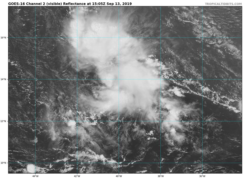
| Figure 1. Visible satellite image of 96L at 11:05 am EDT September 13, 2019. Image credit: tropicaltidbits.com. |
96L headed towards the Lesser Antilles a threat to develop
A tropical wave located on Friday morning near 13.5°N, 39°W, midway between the Lesser Antilles Islands and the coast of Africa, was headed west at about 20 mph. This wave was designated Invest 96L by NHC on Friday morning. The system had a good deal of spin and a modest amount of heavy thunderstorm activity, which was slowly increasing in intensity and areal coverage on Friday morning, as seen on satellite imagery. Conditions appeared favorable for development, with the SHIPS model diagnosing light wind shear of 5 – 10 knots and warm SSTs near 28°C (82°F). However, 96L was encountering dry air from the Saharan Air Layer (SAL), and this dry air was likely slowing development.
The tropical wave is predicted to take a track to the west and then west-northwest over the coming five days, and may spread heavy rains into the Lesser Antilles Islands as early as Sunday night. The core of 96L will likely pass through the islands on Monday. Wind shear is expected to be low through Sunday, then rise to a moderate 10 – 20 knots on Monday, once 96L reaches the Lesser Antilles Islands. This would likely slow development.
The 0Z and 6Z Friday runs of our three top models for predicting tropical cyclone genesis—the GFS, European and UKMET—did not show 96L developing over the coming five days. In their 8 am EDT Friday Tropical Weather Outlook, NHC gave the wave 2-day and 5-day odds of development of 10% and 50%, respectively.
 |
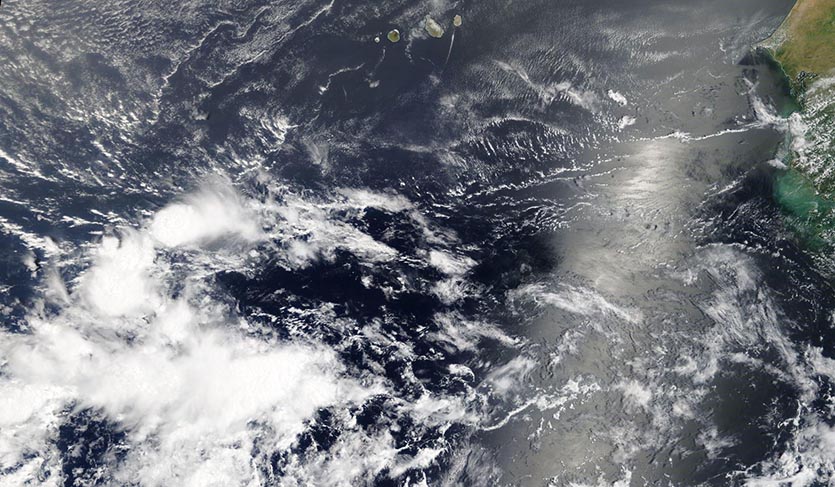
| Figure 2. MODIS satellite image of a tropical disturbance located a few hundred miles south-southwest of the Cabo Verde Islands on Friday morning, September 13, 2019. This system was being given 5-day development odds of 20% by NHC. Image credit: NASA |
New tropical wave off the coast of Africa a threat to develop
A tropical wave located on Friday morning near 10°N, 25°W—a few hundred miles south-southwest of the Cabo Verde Islands—was headed west at about 10 - 15 mph. This wave had not yet been assigned an “Invest” designation by NHC. The system had a modest amount of spin and a small amount of disorganized heavy thunderstorm activity on Friday morning, as seen on satellite imagery. Conditions appeared favorable for slow development, with light wind shear of 5 – 10 knots and warm SSTs near 28°C (82°F). The wave was located far to the south in the Intertropical Convergence Zone (ITCZ), away from the dry air from the Saharan Air Layer (SAL), so dry air should be less of an impediment for development than for 96L.
The tropical wave is predicted to take a track to the west then west-northwest over the coming week, and may spread heavy rains into the Lesser Antilles Islands as early as Thursday. The 0Z and 6Z Friday runs of our three top models for predicting tropical cyclone genesis—the GFS, European and UKMET—had two of them, the GFS and UKMET models, predict that development into a tropical depression would occur by Wednesday. In their 8 am EDT Friday Tropical Weather Outlook, NHC gave the wave 2-day and 5-day odds of development of 0% and 20%, respectively. The models discussed above suggest that this wave may ultimately have a better chance of development than 96L, but perhaps just beyond the five-day window of the Tropical Weather Outlook.
Bob Henson contributed to this post.


