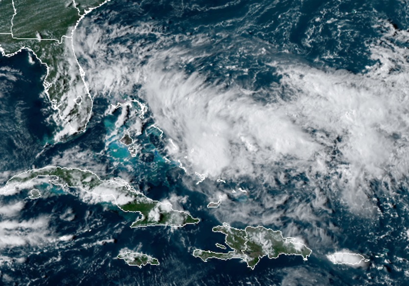
| Above. Infrared image of PTC 9 as of 2249Z (6:49 pm EDT) Thursday, September 12, 2019. Image credit: NASA/MSFC Earth Science Branch. |
Long-suffering residents of the Northwest Bahamas—still coming to grips with the human and physical toll from catastrophic Hurricane Dorian—now face warnings for a system predicted to develop into a tropical storm as soon as Friday night. A disturbance in the Southeast Bahamas was designated Potential Tropical Cyclone 9 by the National Hurricane Center at 5 pm EDT Thursday. The PTC label, introduced in 2017, refers to a disturbance that is not yet a tropical cyclone (typically because it lacks a closed center of circulation) but that could bring tropical storm or hurricane conditions to land areas within 48 hours. The tropical storm warning for the Northwest Bahamas includes all areas except Andros Island.
 |
| Figure 1. GeoColor image of PTC 9 as of 2230Z (6:30 pm EDT) Thursday, September 12, 2019. Image credit: RAMMB/CIRA/CSU. |
PTC 9 consists of a large, disorganized area of showers and thunderstorms (convection) sprawling northeastward from the Southeast Bahamas along a trough of low pressure. The ill-defined center of rotation was located near Rum Cay, about 300 miles southeast of Freeport. However, this has not yet evolved into a closed center of circulation, according to data gathered by Hurricane Hunters late Thursday afternoon.
The main threat from PTC 9 to the Northwest Bahamas is heavy rain and perhaps tropical-storm-force winds, as the system will have little time to intensify further before reaching the islands. Widespread rainfall of 2” to 4” is expected, with pockets of up to 7” possible. These conditions will only add to the misery now being experienced by those who survived Dorian.
New updating radar loop added from the #Bahamas to cover #PTC9 (future #TD9? #Humberto?) at https://t.co/O5tXQxz93p @UMiamiRSMAS @capitalweather pic.twitter.com/xFx689DHhc
— Brian McNoldy (@BMcNoldy) September 12, 2019
Long-term outlook for PTC 9
PTC 9 is tucked within a complex upper-level circulation pattern, and its future is highly uncertain. The main factor now keeping PTC 9 in check is strong southerly wind shear related to an upper-level low across the eastern Gulf of Mexico. Forecast models show this low retreating toward the western Gulf over the next couple of days, with upper-level high pressure building over PTC 9. This shift will make it easier for PTC 9 to strengthen, assuming that the disturbance can consolidate around a well-defined surface low. The 18Z Thursday SHIPS model indicates that wind shear will drop slightly by Friday, from the current 15-20 knots to the 10-15 knot range.
Despite the passage of Hurricane Dorian, which churned up vast amounts of water around the Northwest Bahamas, PTC 9 will have ample oceanic fuel. Sea surface temperatures (SSTs) cooled by 2-3°F along Dorian’s path, but SSTs along the projected path of PTC 9 will still be in the 29-30°C range (84-86°F), which is very supportive of development.
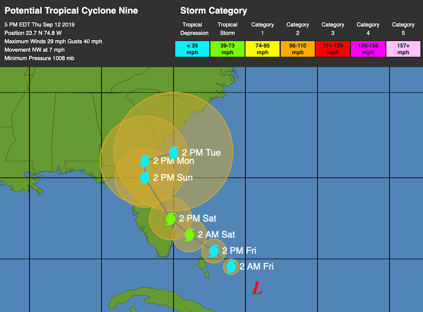
The biggest questions around PTC 9 are track-related. High pressure will predominate at upper levels around PTC 9, with little in the way of strong steering currents. In its late-afternoon forecast Thursday, NHC predicted that PTC 9 would reach the central Florida coast on Saturday as a tropical storm, then arc inland over the weekend and move back offshore near Savannah as a tropical depression by Tuesday. If this forecast holds, tropical storm watches might soon be issued for parts of Florida’s Atlantic coast.
 |
| Figure 2. WU depiction of NHC track forecast for PTC 9 as of 5 pm EDT Thursday, September 12, 2019. |
There are many more question marks in the long-term track forecast for PTC 9 than one might assume from the standard cone of uncertainty, which is based on five years of historical track errors rather than the particulars of PTC 9. Consider the 50-plus European model ensemble members from Thursday morning (12Z): they show PTC 9 making landfall anywhere from the Yucatan Peninsula to Newfoundland! The members largely agree on a northwestward track for the next several days before the paths start to diverge. Some members favor a track near the U.S. East Coast, as in the 0Z and 12Z operational runs of the Euro. Meanwhile, the bulk of GFS ensemble members from 12Z Thursday bring PTC 9 across Florida, with an eventual landfall along the U.S. Gulf Coast. The operational 12Z and 18Z GFS runs bring PTC 9 into the Gulf as an open wave.
“When the GFS and European disagree this starkly, it’s hard to fully believe one over the other, and often a solution more in the middle comes true,” noted Levi Cowan in a video update posted Thursday afternoon at tropicaltidbits.com.
The westward lean of the GFS ensemble is partly because it predicts a weaker system, one that would be driven more by low-level easterly winds. All but one of its 20 members make PTC 9 a tropical storm, but none show hurricane strength. About 80% of the Euro ensemble members bring PTC 9 to tropical storm strength, though only about 20% suggest hurricane strength, mostly after Tuesday. A track that drifts offshore, as suggested near the end of the official NHC forecast, could allow for strengthening well into next week.
PTC 9’s intensity will depend in large part on where a low-level center consolidates and how closely it tracks to land, which adds to the overall uncertainty with this system. The next name on the Atlantic list is Humberto.
The 6-day forecast from the GFS and the ECMWF.
— Sam Lillo (@splillo) September 12, 2019
I don't envy operational forecasters this week. pic.twitter.com/FnLkMo4OkW
Tropical wave headed towards the Lesser Antilles is a threat to develop
As noted in our Thursday morning post, a tropical wave located on Thursday morning a few hundred miles west of the Cabo Verde Islands is headed west at about 20 mph. This wave, which had not yet been given an “Invest” assignment by NHC, had a good deal of spin and a modest amount of heavy thunderstorm activity that was slowly increasing in intensity and areal coverage on Thursday morning, as seen on satellite imagery. Conditions appeared favorable for slow development, with moderate wind shear of 10 – 15 knots, marginally warm SSTs near 27°C (81°F), and a moist atmosphere.
Recent runs of our three top models for predicting tropical cyclone genesis—the GFS, European and UKMET—continued to predict that the system could develop 4 – 7 days from now, after reaching the Caribbean Sea. In their 2 pm EDT Thursday Tropical Weather Outlook, NHC gave the wave 2-day and 5-day odds of development of 0% and 40%, respectively. It is also possible that this system could help spur development a bit further south, within a broad swath of disturbed weather along the Intertropical Convergence Zone.
Dr. Jeff Masters contributed to this post.


