| Above: Visible image of Tropical Storm Kirk at 2:35 pm EDT September 27, 2018. Image credit: Levi Cowan, tropicaltidbits.com. |
Tropical storm warnings were flying on Thursday afternoon for the Lesser Antilles islands of Barbados, St. Lucia, Dominica, Martinique, and Guadeloupe as Tropical Storm Kirk cruised west-northwest at 14 mph through the island chain. With top winds of just 50 mph at 2 pm EDT Thursday, Kirk was primarily a heavy rain threat, with 4 – 6” of rain expected across much of the region. Kirk’s center will pass over or very near the island of Martinique by late afternoon Tuesday. The storm’s heaviest thunderstorms, located on its north side, will affect Martinique, as well as Dominica--the island lying just to the north of Martinique. Up to 10” of rain may fall in these islands, creating a dangerous flash flood and landslide threat. Heavy rains of 2 – 4” are also expected over eastern Puerto Rico from Kirk. Dominica can ill afford serious damage from Kirk rains, as the island suffered catastrophic damage from Category 5 Hurricane Maria last year--$1.4 billion, which was 267% of their GDP. Lesser Antilles radar on Tuesday afternoon showed that Kirk’s heaviest thunderstorms were on track to push into the islands by late Tuesday afternoon.
Satellite loops show that Kirk’s center has been exposed to view, with all of the storm’s heavy thunderstorms pushed to the east side of the center, thanks to strong winds out the west creating high wind shear of 30 knots. The shear should increase even higher by Friday--above 35 knots--leading to the steady dismantlement of Kirk and a death in the Eastern Caribbean over the weekend.
 |
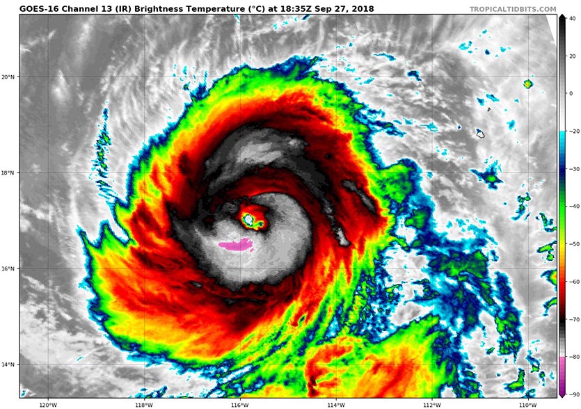
| Figure 1. Infrared image of Hurricane Rosa at 2:35 pm EDT September 27, 2018. Image credit: Levi Cowan, tropicaltidbits.com. |
Hurricane Rosa poised to bring heavy rains to Baja and Southwest U.S.
It’s been a busy hurricane season in the Eastern Pacific, where 17 named storms, 10 hurricanes, and 6 intense hurricanes have formed. An average season has 15 named storms, 8 hurricanes, and 3 intense hurricanes, so we are well past those benchmarks with several more weeks of prime hurricane season remaining.
The tenth hurricane of the season of 2018 is Rosa, which is rapidly strengthening about 550 miles southwest of the southern tip of Mexico's Baja Paninsula. With top sustained winds of 105 mph as of 11 am EDT Thursday, Rosa is feeding on very warm waters (SSTs of around 29°C or 84°F) and a moist surrounding atmosphere (mid-level relative humidity around 70%) amid light wind shear less than 10 knots. These conditions favor Rosa becoming the seventh major hurricane of the season by Thursday. In classic Northeast Pacific fashion, Rosa should begin to weaken as it recurves to the north, encountering cooler waters, dryer air, and high wind shear.
Mexico has been very fortunate this season, with only one landfalling tropical storm so far—Tropical Storm Bud, with made landfall near the tip of the Baja Peninsula on June 14. That luck will change on Tuesday morning, when a weakening Rosa is expected to hit northern Baja California, bringing rainfall amounts of 3 – 6” and the threat of flash flooding and mudslides. Models indicate a large slug of rich moisture will shoot into Arizona beginning on Monday, then spread into much of the Desert Southwest on Tuesday. This moisture will be capable of generating heavy rains of 2 – 3”. Some of this moisture may get all the way to the Midwest by midweek, where it could help stoke yet another round of heavy rains from Minnesota to Michigan.
I’ll have an update on Typhoon Trami in the Western Pacific in our next post.


