| Above: GeoColor satellite image of Tropical Storm Humberto at 0350Z Saturday, September 14, 2019 (11:50 pm EDT Friday). Image credit: RAMMB/CIRA/CSU. |
A loosely organized disturbance just east of The Bahamas gained enough strength late Friday night to become Tropical Storm Humberto, the eighth named system of the 2019 Atlantic hurricane season. A tropical storm warning is in effect for the Northwest Bahamas, except for Andros Island. The tropical storm watch for the east-central Florida coast has been cancelled.
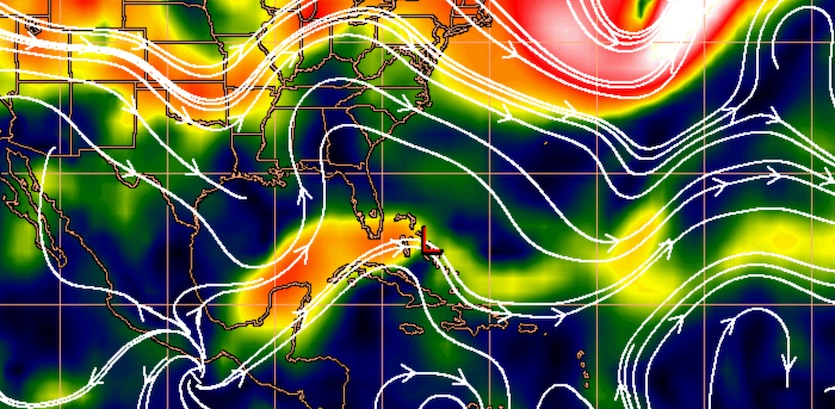
Sustained surface winds in Humberto, as estimated by radiometer from a Hurricane Hunter flight, were around 35 knots (40 mph), which is right at minimal tropical storm strength. Strong wind shear on the north and west sides of Humberto—provided mainly by a persistent upper low in the central Gulf of Mexico—has been tapping the brakes on the storm’s intensification. The most intense showers and thunderstorms (convection) on Friday night were popping along a band well south and east of the center of circulation. A broad shield of weaker convection extended to the north of the center. Only a few stray cells were scattered near the Northwest Bahamas, where residents are still in the early stages of recovery from catastrophic Hurricane Dorian.
Humberto will be slow to intensify until its shear-tilted structure becomes more vertically stacked. As the upper low in the Gulf moves west, wind shear may decrease enough for Humberto to intensify over the weekend while it traverses the warm waters near and north of The Bahamas. Sea surface temperatures (SSTs) decreased by 2-3°F along Dorian’s path as the hurricane churned up cooler subsurface water, but SSTs along the projected path of Humberto will still be near 29°C (84°F), which is very supportive of development. NHC predicts that Humberto will gradually intensify to hurricane strength by Monday.
 |
| Figure 1. Strong southwest winds emanating from an upper low in the Gulf of Mexico have been impinging on Tropical Storm Humberto (the "L" near the Northwest Bahamas), as shown in this mid-level shear analysis from 8 pm EDT Friday, September 13, 2019. Image credit: CIMSS/SSEC/UW-Madison. |
Track forecast for Humberto
Computer models are now in close agreement that Humberto will move slowly northwest over the next couple of days, then get pulled sharply toward the east-northeast by Monday as a strong midlatitude trough passes by. NHC’s forecast track would keep Humberto about 200 miles away from the Southeast U.S. coast. The storm will move past the Northwest Bahamas on Saturday and Saturday night; Great Abaco Island is more likely to experience tropical storm winds than Grand Bahama Island. Widespread rainfall of 2” to 4” is expected across these islands, with pockets of up to 6” possible. These conditions will hamper post-Dorian relief efforts. but will provide much-needed rain to the cisterns used to provide fresh water to the islands.
Rainfall across the Southeast U.S. from Humberto will mostly be under 2”, mainly in areas within 50 to 100 miles of the coast.
Humberto’s expected swing to the east greatly reduces the odds of any major impacts to the Southeast U.S. coast in the short term. There is more track uncertainty late next week, when the trough hauling Humberto eastward could leave the storm behind. A small minority of model ensemble members suggested on Friday that Humberto might try to loop back toward the U.S. East Coast, but the much more likely outcome is a continued path out to sea.
We’ll have a full tropical update on Saturday.
Dr. Jeff Masters contributed to this post.


