| Above: Tropical Storm Alvin as seen at 10:40 am EDT June 26, 2019. At the time, Alvin was a minimal-strength tropical storm with 40 mph winds. Image credit: NOAA/RAMMB. |
The Eastern Pacific finally has its first tropical cyclone of 2019: Tropical Storm Alvin, which formed Wednesday morning in the waters about 450 miles southwest of Manzanillo, Mexico. At 11 am Wednesday, Alvin was a minimal-strength tropical storm with 40 mph winds and was headed west at 14 mph, away from Mexico.
Alvin’s formation date of June 26 comes unusually late for the season’s first named storm. According to CSU hurricane scientist Dr. Phil Klotzbach, only two prior Eastern Pacific seasons in the satellite era (since 1966) have had a later first storm: 1969 and 2016. On average, the Eastern Pacific sees two named storms and one hurricane by June 26. The lack of activity this year is somewhat surprising, since El Niño years typically cause more active-than-usual Eastern Pacific hurricane seasons, and there is an ongoing weak El Niño event.
Tropical Storm #Alvin has formed in the eastern North Pacific (ENP) - the 1st named storm of the 2019 ENP #hurricane season to date. Only 1969 and 2016 had a later 1st named storm formation date in the ENP than has 2019 (in the satellite era - since 1966). pic.twitter.com/7b5wMg7d1G
— Philip Klotzbach (@philklotzbach) June 26, 2019
Forecast for Alvin
Alvin is expected to continue a west to west-northwesterly motion, away from Mexico, and is not a threat to any land areas. Alvin will be over warm waters, under moderate wind shear of 10 – 20 knots, and will have adequate mid-level moisture through Thursday night, which should allow modest intensification to 50 mph winds. By Friday, increasing wind shear and cooling sea surface temperatures should induce a weakening trend, and Alvin will likely dissipate over the weekend.
Long range runs of the GFS model show the possibility of another Eastern Pacific named storm appearing late next week and following a track similar to that of Alvin.
NOAA predicts an above-average hurricane season in the central and eastern Pacific
In their May 23 seasonal forecast, NOAA predicted a 70% chance of an above-normal 2019 hurricane season in both the Eastern Pacific (for storms affecting Mexico) and the Central Pacific (for storms affecting Hawaii). The eastern Pacific outlook calls for a 70% probability of 15 to 22 named storms, of which 8 to 13 are expected to become hurricanes, including 4 to 8 major hurricanes. If we take the midpoint of these ranges, NOAA is calling for 18.5 named storms, 10.5 hurricanes, and 6 major hurricanes--well above the 1981-2010 averages of 15 named storms, 8 hurricanes, and 4 major hurricanes.
The Mexican weather service, Conagua, is also predicting an above-average Eastern Pacific hurricane season. Their May 2019 seasonal forecast called for 19 named storms, 11 hurricanes, and 6 major hurricanes—almost identical to NOAA’s forecast.
NOAA's Central Pacific outlook calls for a 70% probability of 5 to 8 tropical cyclones, which includes tropical depressions, tropical storms, and hurricanes. A near-normal season there has four to five tropical cyclones, and an above-normal season has six or more tropical cyclones. El Niño conditions typically lead to more active hurricane seasons in both the eastern and central Pacific, due to warmer-than-average ocean temperatures.
 |
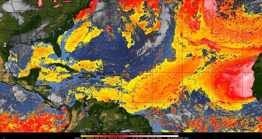
Figure 1. The Saharan Air Layer (SAL) analysis for June 26, 2019, showed dry Saharan air (yellow and orange colors) dominating the tropical Atlantic. Saharan dust was also present over Florida and the Gulf of Mexico. Image credit: University of Wisconsin CIMSS. |
 |
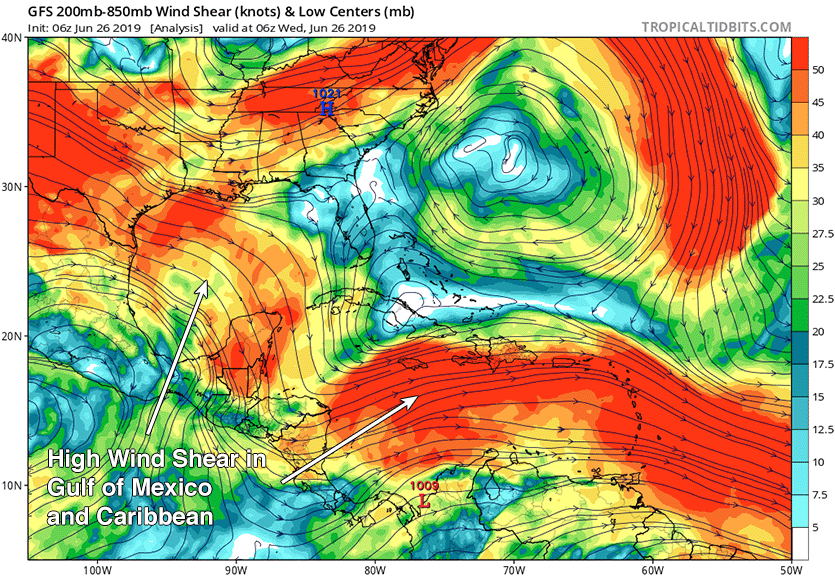
| Figure 2. Wind shear at analyzed by the GFS model at 2 am EDT Wednesday, June 26, 2019. High wind shear of 30 – 50 knots was present over the Gulf of Mexico and Caribbean. Image credit: tropicaltidbits.com. |
Quiet in the Atlantic
The Atlantic has been quiet for all of June, and the 8 am EDT Wednesday Tropical Weather Outlook from NHC called for no new tropical cyclones in the coming five days. High wind shear continues to dominate the usual breeding grounds for June tropical storms, the Caribbean and Gulf of Mexico. Lower wind shear is present in the waters from Florida through the Bahamas, where June activity is also common. Ocean temperatures are above average through much of the tropical Atlantic, but a large outbreak of dry air and African dust is creating hostile conditions for tropical storm formation. Long-range Wednesday morning runs of the GFS and European models and their ensembles were not showing any areas of concern for the Atlantic during the coming ten days.


