|
| Above: California’s Camp Fire as seen by the Landsat-8 satellite on November 8, 2018. Image credit: U.S. Geological Survey, processed by Pierre Markuse. |
Dangerous climate change is here now. That’s the take-home message from 2018’s extraordinary series of extreme weather events—including at least 37 billion-dollar weather disasters—which demonstrated that dangerous climate change is not a distant future threat, but today’s reality. This year’s preliminary tally of 37 billion-dollar weather disasters would be the third most on record, according to insurance broker Aon Benfield. The only years with more were 2010 and 2013, which both had 41.
The high number of disasters was due, in part, to an unusually persistent and extreme summertime jet stream pattern that brought extended periods of extreme weather to parts of the Northern Hemisphere. Research published in October blamed “stuck” jet stream patterns like this on human-caused climate change, and predicted that our future climate is likely to bring a significant increase in such destructive jet stream patterns.
Here, then, is our pick of the top ten weather and climate events of 2018:
 |
| 1. Another top-five warmest year on record. The year-to-date period of January – November ranks as the fourth warmest such period on record, and 2018 is a virtual lock to be the fourth-warmest year on record once the numbers from December come in. This means that the five warmest years on record globally will be the last five years—2014 through 2018. If an El Niño event develops and extends into early 2019, as predicted, it is likely that 2019 will end up even warmer than 2018. Above: departure of Earth’s temperature from average between 1880 – 2018, for the year-to-date period of January - November. Image credit: NOAA. |
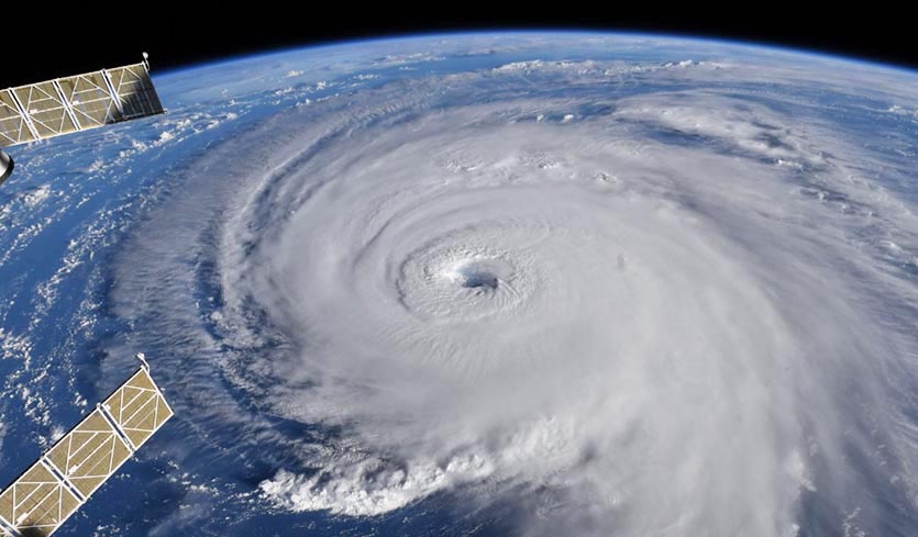 |
2. Hurricane Florence. For the second year in a row, a very slow-moving hurricane smashed all-time record rainfall records in the U.S., as Hurricane Florence’s rains broke the U.S. rainfall records for North Carolina and South Carolina. The three largest U.S. rainfall events, when measured by how much rain fell over an area of 14,000 - 20,000 square miles over a 4-day period, have all occurred in the past three years--Hurricane Florence in the Carolinas in 2018, Hurricane Harvey in Texas/Louisiana in 2017, and a March 2016 storm in Louisiana. This is the type of behavior one might expect to see with global warming putting more moisture into the atmosphere and increasing the frequency and intensity of heavy precipitation events. A "pre-attribution" study carried out prior to landfall estimated that, because of climate change, Florence’s most intense rains over North Carolina would be more than 50% heavier than they would have been otherwise. Above: ISS image of Hurricane Florence at 9 am EDT Wednesday, September 12, 2018. Image credit: Ricky Arnold. |
 |
3. Hurricane Michael. The most expensive weather-related disaster of 2018 was Hurricane Michael, which made landfall on October 10, 2018, near Mexico Beach, Florida, with top sustained winds of 155 mph and a central pressure of 919 mb. Hurricane Michael’s landfall pressure was the third lowest for a continental US hurricane landfall on record, and its landfalling winds were the fourth highest for a continental U.S. landfall on record. Catastrophic damage in excess of $15 billion resulted, along with at least 49 direct and indirect deaths. Above: Homes and businesses along U.S. 98 are left in devastation by Hurricane Michael on Friday, Oct. 12, 2018, in Mexico Beach, Fla. Image credit: Mark Wallheiser/Getty Images. |
 |
4. Year of the deadly mega-wildfire. Two of the top twelve deadliest wildfires in world history hit in 2018: the November 9 Camp Fire in and near Paradise, California which killed 86, and the July Attica wildfires in Greece which killed 126 (EM-DAT). Below is the top twelve list of deadliest wildfire events globally, according to EM-DAT and other official and unofficial data sources. It is sobering to note that we have seen a resurgence in very deadly fires in the 21st century, after seeing a notable absence in the middle and late 20th century. The recent resurgence is largely due to our increased vulnerability (more people living in the wildland/urban interface) plus more extreme fire weather (hotter, drier heat waves due to human-caused climate change), plus bad luck. - 1200 - 2500 deaths, 1871 (Peshtigo Fire, Wisconsin)
- 1200 deaths, 1936 (Kursha-2 Fire, Soviet Union)
- 453 deaths, 1918 (Cloquet Fire, Minnesota)
- 418+ deaths, 1894 (Hinkley Fire, Minnesota)
- 282 deaths, 1882 (Thumb Fire, Michigan)
- 240 deaths, 1997 (Indonesia forest fires)
- 223 deaths, 1916 (Great Matheson Fire, Ontario, Canada)
- 191 deaths, 1987 (Black Dragon Fire, China and Soviet Union)
- 180 deaths, 2009 (Black Saturday bushfires, Australia)
- 160 deaths, 1825 (Miramichi Fire, New Brunswick, Canada)
- 126 deaths, 2018 (Attica, Greece)
- 86 deaths, 2018 (Camp Fire, California)
Also worth noting: An unprecedentedly powerful EF3 "fire tornado" struck near Redding, California as part of the Carr Fire. That fire killed 8, cost over $1 billion, and was the seventh largest fire in California history. California also suffered its largest fire on record in 2018—the 459,000-acre Mendocino Complex Fire of July through August—and the Camp Fire was the state's most destructive on record, with more than 18,800 structures lost. Above: Firefighters try to extinguish flames during a wildfire at the village of Kineta, near Athens, Greece, on July 24, 2018. Image credit: Valerie Gache/AFP. |
 |
| 5. Multiple deadly heat waves. An incredibly intense and long-lasting heat wave hit East Asia during late July and early August, breaking the all-time heat records for Japan (106.0°F) and South Korea (105.8°F). The heat is being blamed for 119 deaths in Japan and 28 in South Korea. A high death toll was almost certainly experienced in North Korea, where 21 out of 24 major weather stations set all-time heat records during the heat wave, according to weather records expert Maximiliano Herrera. North Korea has very little air conditioning, and most households outside Pyongyang don't even have electricity, and thus no fans. Other heat waves with high deaths tolls hit Quebec, Canada in July (70 killed), and Pakistan in May (180 killed). Above: Electric fans are displayed for sale on a street in the Myeongdong shopping district in Seoul on August 1, 2018. Temperatures in Seoul reached 39.6°C (103.3°F) on August 1, marking the highest for the city in 111 years of recordkeeping. Image credit: Ed Jones/AFP/Getty Images. |
 |
| 6. Monsoon flood in India. The deadliest weather disaster of 2018 was catastrophic monsoon flooding in southwest India’s Kerala state in August, which left 500 people dead or missing in the state’s worst flooding since 1924. More than 23,000 homes were damaged or destroyed, 2.24 million acres of cropland were inundated, and nearly 4,000 miles of roadway segments and 134 bridges were washed away or damaged. Total damage was estimated at $5.5 billion. Above: Volunteering members of the Kerala Adventure Sports Club carry flood relief material for marooned villages on the outskirt of Kozhikode district, north of Trivandrum, Kerala, on August 17, 2018. Troop reinforcements stepped up desperate rescue attempts in India's flood-stricken Kerala state on August 17 after more than 100 bodies were found in a day and a half. Image credit: Manjunath Kiran/AFP/Getty Images. |
 |
| 7. Ten Category 5 storms. Ten Category 5 storms were observed globally in 2018, the second highest number of Cat 5s on record (since 1990). The only year with more was 1997, with twelve. Yutu, Willa, Kong-rey, Walaka, Trami, Marcus, Maria, Lane, Jebi, and Mangkhut were this year’s Cat 5s, and it’s possible that post-season analysis will give us two more: Hurricane Hector in the Central Pacific just missed making Category 5 status, topping out with 155 mph winds, and Hurricane Michael in the Atlantic also had 155 mph winds. Above: A rare atmospheric event—simultaneous Cat 5s. Super Typhoon Kong-rey (left) and Hurricane Walaka (right) roil the Pacific Ocean at 10 pm EDT October 1, 2018. This was just the seventh time in recorded history that Earth had simultaneous Cat 5s. Image credit: NOAA/RAMMB. |
 |
| 8. Super Typhoon Yutu hits U.S. Northern Mariana Islands. Earth's strongest storm of 2018, Super Typhoon Yutu, hit Tinian Island in the U.S. Northern Mariana Islands on October 25 with sustained winds of 180 mph. Winds this strong at landfall are rarely observed, and Yutu is tied for fifth place for strongest tropical cyclone at landfall in world history, according to data from the National Hurricane Center (NHC) and Joint Typhoon Warning Center (JTWC). Ominously, 7 of the 10 strongest landfalls in recorded history have occurred since 2006. The only stronger landfall in the U.S. or its territories was the 1935 Labor Day hurricane in the Florida Keys, with 185 mph winds. Above: Infrared Himawari image of Super Typhoon Yutu at 10:10 am EDT October 24, 2018. At the time, Yutu was a Category 5 storm with 180 mph winds, and its northern eyewall was affecting Tinian Island in the Northern Marianas. Image credit: NOAA/RAMMB. |
 |
9. Seven billion-dollar droughts. Seven billion-dollar droughts hit Earth in 2018: Northern and Central Europe ($7.5 billion), Argentina/Uruguay ($3.9 billion), China ($3.5 billion), U.S. ($2 billion), South Africa ($1.2 billion), Australia ($1.2 billion), and India ($1.1 billion). The northern European drought was made at least 2 – 5 times more likely at some locations by climate change, according to a preliminary analysis by the World Weather Attribution network.The drought in South Africa was so severe that the city of Cape Town came within a few weeks of running out of water. Fortunately, waters in the city’s reservoirs have rebounded in recent months, thanks to draconian conservation measures and timely rains. Above: Sad, dried sunflowers in a field near Magdeburg, eastern Germany on July 26, 2018. Image credit: Tobias Schwarz/AFP/Getty Images. |
 |
10 (Tie). Japan flood. Historic rainfall from June 29 to July 8 led to catastrophic flash flooding and mudslides across Japan, leaving at least 230 people dead—their deadliest flood event since 1982. More than 40” (1,015 millimeters) of rain fell across parts of Kochi, Gifu, and Nagano prefectures and Tokushima. The rains, which were heaviest from July 4 to 7, were spawned by the presence of a stationary seasonal frontal boundary enhanced by remnant moisture from Typhoon Prapiroon. Floodwaters of up to 5.0 meters (16.4 feet) in height led to catastrophic inundation in some areas, with nearly 50,000 homes and other structures damaged or destroyed. Total damage was estimated at $7 billion. According to a preliminary analysis released by the World Weather Attribution network, the disaster was made more likely by climate change, but the data was too noisy to compute by how much. Above: An emergency crew works at the site after a train derailed due to landslides caused by heavy rain in Karatsu city, Saga prefecture on July 7, 2018. Image credit: STR/AFP/Getty Images. |
 |
| 10 (Tie). Record-low tornado deaths. Tornadoes have been responsible for 10 deaths in the United States as of December 29. This is lower than the year-end total of tornado-related deaths for every prior year dating back to 1875. In an average year, 69 people are killed by tornadoes in the U.S. Furthermore, there have been no violent EF4 or EF5 tornadoes in the U.S. in 2018. This is the first year since accurate record-keeping began in 1950 that has not featured at least one violent tornado. As detailed by the Captial Weather Gang's Ian Livingston, 2018 is also on pace to have the fewest EF3 or stronger tornadoes (12). The previous record was 15 in 1987. The notable lack of strong and violent tornadoes this year was due, in part, to higher than normal atmospheric pressures during the peak months for our worst tornadoes, April and May. In addition, research shows that the last several decades have seen a trend toward increased variability of tornadoes on both monthly and yearly time scales. Above: A group from Puget Sound, Washington, caught this dramatic photo of a large wall cloud in central Kansas on Tuesday, May 1, 2018. Image credit: Courtesy Michael Snyder, @guyinjeep16. |
For more details on the top climate-related stories of 2018, check out Bob Henson's roundup at weather.com.
Bob Henson contributed to this post.


