| Above: GOES-16 visible image of TD 17 at 11:20 am EDT October 25, 2019. Image credit: NOAA/RAMMB. |
Tropical Depression 17 formed in the western Gulf of Mexico on Friday morning, and is expected to make landfall in Louisiana on Friday night after merging with a cold front and becoming a very rainy non-tropical low pressure system. Heavy rains were already affecting the coast of Louisiana on Friday morning, as seen on New Orleans radar. A Flash Flood Watch and Flood Advisory were in effect for New Orleans, where up to an inch of rain had fallen by 9:13 am CDT Friday, with another 2 – 3” expected. NOAA’s Storm Prediction Center has placed coastal southeast Louisiana and Mississippi in their “Slight Risk” area for severe weather on Friday, and a tornado watch was posted for portions of coastal southeast Louisiana, Mississippi, and Alabama.
Friday afternoon satellite images of TD 17 showed a well-defined surface circulation with a modest-sized area of heavy thunderstorms along the northeast side of its circulation. Wind gusts as high as 38 mph were reported on Friday morning at buoy 42055, located about 50 miles to the northwest of the center of TD 17. Interestingly, even stronger winds were reported Friday morning in the Gulf of Mexico waters between TD 17 and the coast of Texas, where a strong cold was advancing eastwards. In this region, buoy 42019 reported sustained winds of 40 mph, gusting to 51 mph, at 5:30 am CDT. Winds at the Brazos 133 Oil Platform (located at 30 feet altitude) were sustained at 48 mph, gusting to 60 mph, at 4:35 am CDT Friday.
Conditions were marginal for further development of TD 17, due to high wind shear near 25 knots. However, TD 17 had favorable ocean temperatures near 29°C (84°F), and a very moist atmosphere with a mid-level relative humidity near 70%. The sea surface temperatures were about 1.5 – 2.0°C (2.5 - 3.6°F) above average for this time of year.
A hurricane hunter aircraft will investigate TD 17 on Friday afternoon to see if TD 17 is a tropical storm; the next name on the Atlantic list of storms is Olga. The most recent named storm to form this late in the calendar year in the Gulf of Mexico is Juan, which became a tropical storm on October 26, 1985.
 |
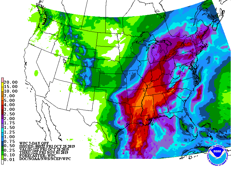
| Figure 1. Predicted 7-day precipitation amounts ending at 8 am EDT Friday, November 1, 2019. These totals include additional rains later next week following the rains associated with TC 17 and a cold front this weekend. Image credit: NOAA. |
Forecast for TD 17
The strong cold front advancing towards TD 17 will overtake it by Friday night, converting the system to a non-tropical low pressure system. This transition will do little to alter its heavy rains, which are expected to be 2 – 4”, with isolated areas up to 8”, over the central Gulf Coast. The trough of low pressure associated with the cold front approaching TD 17 will force the system on a north-northeasterly track, bringing the center ashore on Friday night over Louisiana. Another heavy dose of rain is expected across the region next week, which could push 7-day rainfall totals into the 5 – 7" range (see Figure 1).
 |
| Figure 2. GeoColor image of Invest 98L at 1510Z (11:10 am EDT) Friday, October 25, 2019. Image credit: RAMMB/CIRA/CSU. |
Subtropical or tropical storm could form near the Azores
NHC is also keeping an eye on Invest 98L in the Northeast Atlantic. The area of interest is a compact core of showers and thunderstorms (convection), within a much larger circulation linked to an upper-level low. Sea surface temperatures are well below the 26°C (79°F) threshold typically associated with tropical development. The convective core is not especially strong but is quite distinct and well-organized on satellite. ASCAT scatterometer data on Friday morning showed a large area of winds exceeding tropical storm strength on the western side of the broad circulation, with a separate pocket of winds close to tropical storm strength near 98L’s center.
At 9:45 am EDT, the National Hurricane Center issued a special Tropical Weather Outlook noting the organization of 98L and stating that a tropical or subtropical cyclone could form later on Friday. Given the cool waters, and the presence of the upper low and its strong wind shear (30-35 knots), any development of 98L is more likely to be subtropical than tropical. Either case would result in a new named storm. Forecast models take 98L southeast, then northeast, on a track that could pass over parts of the Azores this weekend. The compact size of 98L suggests that its core could both intensify and weaken quickly, in tandem with upper-level dynamics. Conditions do not favor it reaching much more than minimal tropical- or subtropical-storm-strength, if that.
 |
| Figure 3. GeoColor image of Invest 98L at 1510Z (11:10 am EDT) Friday, October 25, 2019. An eye-like feature was apparent, though the heavy thunderstorms surrounding it were relatively shallow with warm cloud tops. Image credit: RAMMB/CIRA/CSU. |
Rare eastern-Mediterranean “medicane” heading for Egypt
A system bearing many hallmarks of a tropical cyclone is bearing down on the northern coast of Egypt late Friday. This low pressure center had a symmetric warm core, according to analyses by Florida State University. The cyclone was traveling over waters in the easternmost Mediterranean north of Egypt with sea surface temperatures of 26-28°C (79-82°F). That’s warm enough for tropical development, and about 2°C (3.6°F) warmer than average for late October.
What a name for a #Medicane... #MedicaneScott is about to make landfall in Egypt. Weather models are unlikely to capture local high rainfall totals and damaging winds.
— Scott From Scotland (@ScottDuncanWX) October 25, 2019
Managed to sneak some ASCAT wind obs valid one hour ago... This warm-cored storm shouldn't be underestimated. pic.twitter.com/y3bT2YA0BP
The cyclones informally known as “medicanes” typically spin up across the central and western Mediterranean. Limited to a compact basin, these are typically hybrid-type systems and rarely exceed low-end tropical storm strength. This example is further east than any of the cases in a 2014 long-term climatology of medicanes produced by Leone Caviccia (Centro Euro-Mediterraneo sui Cambiamenti Climatici) and colleagues. As noted by Tomer Burg (University of Oklahoma), this system developed from an upper-level low that’s been lingering over the region for days. Moisture pushed into Egypt by this pattern contributed to flash floods in Cairo and elsewhere that killed at least 11 people earlier this week.
The medicane will be moving onshore across far northeast Egypt late Friday, bringing unusually heavy rains of 1-2” to the Sinai Peninsula and Israel’s southern Negev desert. Some of these places could receive a year’s worth of rainfall (or more) in a day or two.
 |
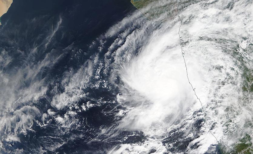
| Figure 4. MODIS image of Tropical Cyclone Kyarr on Friday morning, October 25, 2019. Image credit: NASA. |
Tropical Cyclone Kyarr forms off the west coast of India
The India Meteorology Department (IMD) and Joint Typhoon Warning Center (JTWC) are issuing advisories on Tropical Cyclone Kyarr, which formed on October 24 off the west coast of India. At 11 am EDT Friday, Kyarr was a strong tropical storm with 65 mph winds, moving slowly north-northeast at 4 mph. Both IMD and JTWC predict that a ridge of high pressure will build in to the north of Kyarr this weekend and force the storm westwards towards Oman. Kyarr is expected to take advantage of moderate wind shear near 15 knots and favorable ocean temperatures near 29°C (84°F) and intensify to Category 3 hurricane strength by Monday. Thereafter, entrainment of dry air from the Middle East may be able to weaken the storm before it makes landfall on the Arabian Peninsula.
Bob Henson co-wrote this post.


