| Above: GOES-16 image of Florence at 10:45 am EDT September 11, 2018. Image credit: NOAA/RAMMB. |
A Hurricane Watch and a Storm Surge Watch are up for the entire coast of North Carolina and most of the coast of South Carolina as Category 4 Hurricane Florence heads west-northwest towards an expected Thursday night/Friday morning landfall. Florence weakened to a borderline Category 3/Category 4 hurricane on Tuesday morning, but is likely to strengthen again Tuesday evening through Wednesday. The odds continue to increase that Florence will stall on Friday and meander near or over the coast for several days, making the hurricane a devastating rainfall and coastal flooding threat.
View from inside the eye of category 4 #HurricaneFlorence today onboard the NOAA P-3 #NOAA42. (Video credit: Heather Holbach) pic.twitter.com/eEYOI2PBnh
— HRD/AOML/NOAA (@HRD_AOML_NOAA) September 10, 2018
The Hurricane Hunters and microwave satellite imagery this morning showed that Florence’s weakening was due to an eyewall replacement cycle (ERC). During this phenomenon, common in intense hurricanes, the eye shrinks to such a small diameter (typically around 10 – 15 miles) that the eyewall becomes unstable and collapses. The hurricane then creates a new larger-diameter eyewall out of a spiral band. During this process, the peak winds typically fall by 10 – 15 mph, and the central pressure can rise 10 – 15 mb.
The Hurricane Hunters measured top surface winds of 130 mph at 6:47 am EDT Tuesday, down from the 140 mph peak winds of Monday, and Florence’s central pressure had risen to 951 mb, up from the 939 mb value measured on Monday. The aircraft noted that the north side of Florence’s eyewall was missing, and the eye had expanded from 12 miles in diameter on Monday to a diameter of to 35 miles on Tuesday morning. The University of Wisconsin/CIMSS has an animation of microwave satellite imagery that shows the process quite well.
The eyewall replacement cycle predicted earlier today by the ARCHER-ERC, a statistical-dynamical model for #eyewall structure, is currently occurring, as seen in this #MIMIC PW loop. Expect a very different-looking #Florence tomorrow when the sun comes up. pic.twitter.com/SrRGIgqoa7
— Jonathan Vigh (@skywatcher77) September 11, 2018
Unfortunately, Florence has plenty of time to recover from this eyewall replacement cycle, and hurricanes usually begin to re-intensify within 12 hours of closing off their new eyewall. Florence had closed off its new eyewall as of 8:32 am EDT Tuesday, according to data from the Air Force hurricane hunters. After an ERC is complete, a hurricane’s wind field will expand, subjecting a larger area of the ocean to strong winds and allowing a larger storm surge to build. At 11 am EDT Tuesday, Florence was a medium-to-small-sized hurricane, with tropical storm-force winds that extended out up to 150 miles from the center. Hurricane-force winds extended out 40 miles from the center. These numbers will increase today as the hurricane recovers from the ERC.
At 11 am EDT Tuesday, Florence was about 390 miles south of Bermuda, moving west-northwest at 16 mph. Sea surface temperatures (SSTs) were a warm 29° - 29.5°C (84° - 85°F), which is about 2°- 4°F above average. Florence was embedded in an atmosphere with dry air (a mid-level relative humidity of 50%). However, with wind shear a light 5 - 10 knots, the hurricane has successfully walled off this dry air, and has been minimally affected by it. Satellite images on Tuesday morning showed that the hurricane had a less impressive appearance than on Monday, with the eye less distinct and partially filled with clouds. The intensity of Florence’s eyewall thunderstorms had also decreased, with warmer cloud tops.
 |
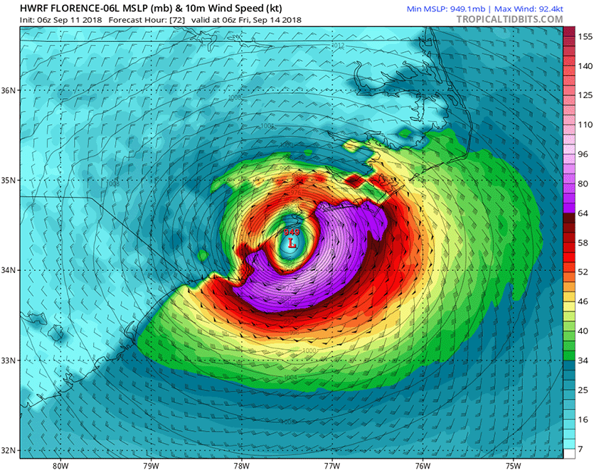
| Figure 1. HWRF model winds and pressure forecast for 2 am EDT Friday, September 14, from the 6Z Tuesday run of the model. The HWRF model was our top intensity model from 2017, and predicted that Florence would make landfall near the South Carolina/North Carolina border as a Category 2 hurricane with winds of 105 mph. Image credit: Levi Cowan, tropicaltidbits.com. |
Intensity forecast for Florence: expect a strong Cat 4 by Wednesday
Florence’s environment is very conducive for intensification. The SHIPS model predicts shear will remain low through Wednesday night. SSTs will remain near 29°C (84°F) during this period, and ocean heat content will be high, near 35 - 50 kilojoules per square centimeter. Satellite imagery shows that Florence has developed two upper-level outflow channels, one to the NW and one to the east, and this configuration should allow the hurricane to steadily intensify until Thursday.
Our top three intensity models unanimously predict strengthening of Florence into a Category 4 hurricane with 140 mph winds by Wednesday night, and the storm is also expected to increase in size. Florence will still be embedded in a relatively dry atmosphere, so it is possible the storm could suffer from dry air intrusions that would interfere with the intensification process, but this will likely not occur until Thursday, when wind shear is expected to increase to a moderate 10 – 15 knots. The top three intensity models all predicted that Florence would weaken on Thursday as it approached landfall, hitting as a Category 3 storm with 115 – 125 mph winds. This weakening is to be expected, since the hurricane will be moving slowly over shallower waters with low heat content, providing less energy to the storm.
 |
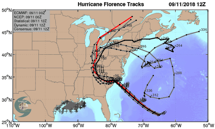
| Figure 2. The 0Z Tuesday, September 11, 2018 track forecasts by the operational European model for Florence (red line, adjusted by CFAN using a proprietary technique that accounts for storm movement since the time of the model run), along with the track of the average of the 50 members of the European model ensemble (heavy black line), and the track forecasts from the “high probability cluster” (grey lines)—the four European model ensemble members that have performed best with Florence thus far. These forecasts were very unified on a landfall Image credit: CFAN. |
Track forecast for Florence: expect a North Carolina or South Carolina landfall
All of the forecasts from our top five models agreed on Tuesday morning that Florence would hit North Carolina or South Carolina on Thursday evening or Friday morning. The exact location of Florence’s landfall is still fuzzy, as the average error in a 3-day NHC forecasts is about 100 miles. While the GFS model predicts a more northeastly track than the European model, the European model likely has a better handle than the GFS on Florence's approach to the U.S. Coast, according to this highly technical but fascinating series of tweets by researcher Philippe Papin (U.S. Naval Research Laboratory). Basically, the GFS uses an older microphysics scheme that may be overdeveloping the northeast side of Florence, pulling the hurricane a bit more in that direction prior to landfall. The model that will soon replace the GFS, the GFS FV3, does a better job on this feature, and its track is closer to the European model track.
 |
| Figure 3. Predicted 7-day rainfall amounts from Florence. Image credit: NHC. |
Overnight Euro painting a very grim picture for the #Carolinas with flooding rainfall. There is a real threat that #Florence can slow on its approach and even stall inland bringing catastrophic rainfall to the region. Widespread 10-15", locally 20-40" if Euro verifies #scwx #ncwx pic.twitter.com/twAnErzljL
— John Kassell (@JPKassell) September 11, 2018
Overnight Euro painting a very grim picture for the #Carolinas with flooding rainfall. There is a real threat that #Florence can slow on its approach and even stall inland bringing catastrophic rainfall to the region. Widespread 10-15", locally 20-40" if Euro verifies #scwx #ncwx pic.twitter.com/twAnErzljL
— John Kassell (@JPKassell) September 11, 2018Florence: an extreme rainfall threat
Our top five models all agree that the trough of low pressure that was expected to turn the hurricane to the north late this week will be too weak to do so, as a strong ridge of high pressure builds over the Mid-Atlantic. This “blocking ridge” is likely to block Florence’s forward progress. Florence is expected to stall and wander near or over the coast for as many as four days, dumping prodigious amounts of rain. If a significant portion of the storm’s circulation remains over water, as occurred last year with Hurricane Harvey’s stall over Southeast Texas—or even if Florence were to move into the higher terrain of western North Carolina and then stall—the rain from Florence may break all-time state records for rainfall from a hurricane or tropical storm. North Carolina’s state rainfall record from a hurricane is 24.06” from Hurricane Floyd of 1999, South Carolina’s is 18.51” from Tropical Storm Jerry of 1995, Virginia’s is 27.00” from Hurricane Camille of 1969, and West Virginia’s is 7.94” from Hurricane Agnes of 1972. As we discussed in yesterday’s post, soils are near saturation in some areas of Florence’s likely heavy rain zone, thanks to a record-wet summer. Heavy rains run off of wet soils and create bigger floods. There is also the danger that Florence could make landfall, then emerge back over water and re-intensify, increasing its rainfall potential.
 |
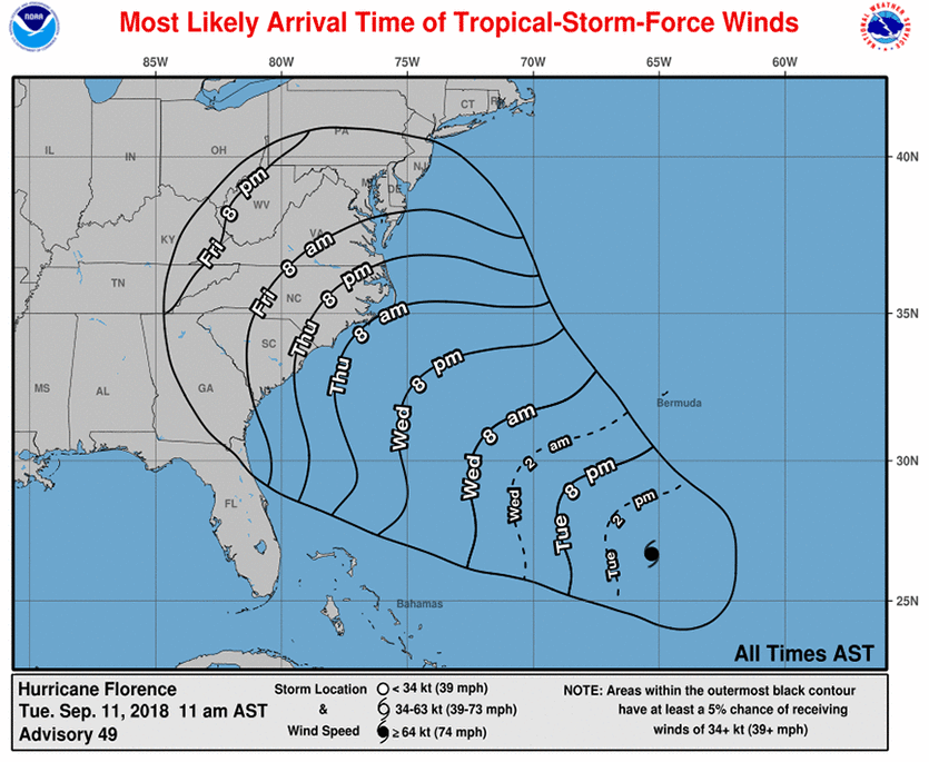
| Figure 4. Predicted arrival time of tropical-storm-force winds from Florence. Image credit: NHC. |
Expect a storm surge of 6 - 12 feet near and to the right of where the eye makes landfall
Although Florence is only a medium-small hurricane right now, the hurricane is expected to increase in size, creating a large storm surge that will likely bring a 6 – 12 foot inundation of the coast along an 80 mile-wide stretch near and to the right of where the eye comes ashore, according to the 11 am EDT NHC advisory. The highest surge will come over a 10 – 40 mile-wide stretch where the right-hand eyewall makes landfall. As I discussed in detail in yesterday’s post, Expect a Storm Surge of 15 - 20 Feet in a Landfalling Category 4 Storm in the Carolinas, two of the three historical Category 4 hurricanes that have hit the Carolinas have generated a storm tide of 18 - 20 feet: Hugo of 1989 and Hazel of 1954. If Florence expands in size to become a large hurricane, and hits as a Category 4, it could potentially bring a 15 – 20’ maximum storm tide to the coast. The storm tide is the combination of the storm surge and the normal lunar tide, measured in height above sea level. The National Hurricane Center uses the terminology “height above ground level” when discussing the storm tide, meaning the height the surge (plus tide) gets above the normal high tide mark. Storm surge expert Dr. Hal Needham has an excellent discussion of why we might expect Florence to have a lower storm surge than Hugo or Hazel.
It matters critically when the storm surge hits in relation to the tidal cycle, since the range between low and high tide along much of the coast of North Carolina is 4 – 5 feet. In Wilmington, NC, the worst time for the surge to arrive would be within an hour of one of their high tides: 1:24 pm Thursday, 1:38 am Friday, or 2:16 pm Friday. The difference between high and low tide is about five feet there. As I discussed in Friday’s post, Friday: Increased Storm Surge Damage From Florence Due to the Moon’s Phase, the tides on Thursday are higher than usual, due to the phase of the moon. In Morehead City, the high tides peak about two hours earlier than at Wilmington, and tidal range between low and high tide is about four feet.
If you are under a storm surge watch and are asked to evacuate for the storm surge, get out! Tropical storm-force winds may begin along the coast as early as Thursday morning, making it difficult or impossible to evacuate.
Bob Henson contributed to this post.


