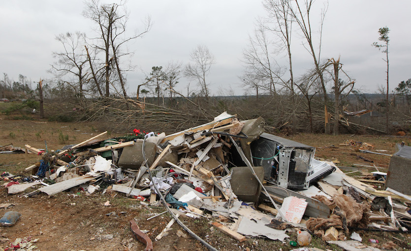
| Above: Damage at the Buck Wild Saloon, located on U.S. Highway 280, east of Smiths Station, Alabama, Sunday, March 3, 2019. Image credit: Kara Coleman Fields/Opelika-Auburn News via AP. |
At least 23 people were killed on Sunday by a rapid-fire tornado outbreak focused on southern Alabama and Georgia and the adjacent Florida Panhandle. Sunday’s was the largest single-day U.S. tornado toll since at least May 20, 2013, when 24 people were killed in a tornado that struck central Oklahoma. Much of the damage from Sunday's tornadoes occurred in rural areas. The hardest-hit areas included Lee County, AL, and the town of Cairo, GA. Update: The deadly tornado that struck Lee County, Alabama, Sunday afternoon was given a preliminary rating of EF4 on the Enhanced Fujita Scale, the National Weather Service confirmed Monday. It is the first EF4 or stronger tornado in the United States in nearly two years; the last EF4 touched down in Canton, Texas, April 29, 2017.
The death toll may rise further. The Lee County Sheriff’s Office said a number of people had not been accounted for as of Monday morning, as reported by weather.com. All of the 23 deaths reported as of that point were in Lee County.
 |
| Figure 1. Approximate locations of tornadoes on Sunday, March 3, 2019. Image credit: weather.com. |
The Lee County tornado crossing US 280 yesterday near Smiths Station. You can see the cell tower collapse at the beginning of the video. From Louis Bridges pic.twitter.com/YIYuZn5XnB
— James Spann (@spann) March 4, 2019
Sunday’s round of tornadoes fits the climatological and geographic template for a late-winter/early-spring outbreak. Tornado season typically gets under way by now in the Deep South, where some of the worst twisters on record have occurred in February and March.
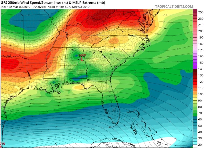
The outbreak on Sunday developed from several intense supercell thunderstorms, including one that formed just ahead of a powerful cold front plowing through the Southeast. Very warm, humid surface air for early March was in place ahead of the front. The surface low associated with the pattern was not especially strong (only about 1005-1007 mb), but an approaching jet streak—a corridor of especially strong wind within the polar jet stream—helped foster upward motion and strong vertical wind shear. For more on the factors leading up to Tuesday's tornadoes, see the analysis by Chris Dolce at weather.com.
 |
| Figure 2. Winds at the jet-stream level (250 mb, or about 34,000 feet) analyzed by the GFS model at 1 pm EST Sunday, March 3, 2019, just before damaging thunderstorms erupted in southern Alabama. A strong jet streak with winds topping 110 knots (125 mph) was approaching the South. The deadly tornadic supercell in Lee County, AL, formed in the warm sector just southeast of the 1007-mb low in central Alabama. Image credit: tropicaltidbits.com. |
As of mid-morning Monday, the NOAA/NWS Storm Prediction Center had compiled 39 tornado reports, all from between 2:30 and 9:00 pm EST Sunday. The final number of tornadoes for the outbreak is likely to change as duplicate reports are filtered out and tornado paths are analyzed more closely. Survey teams organized by the NWS offices in Birmingham and Mobile, Alabama, and Tallahassee, Florida, were at work Monday morning in chilly conditions behind a strong cold front.
A total of 97 tornado warnings were issued on Sunday—the most on a single day since Dec. 23, 2015, according to The Weather Channel's Greg Diamond.
The region hit hardest by Sunday's outbreak has a large number of manufactured homes in rural areas, which most likely contributed to the day's tragic death toll. For the period 1985-2005, about 44% of the 1091 U.S. tornado deaths were in mobile homes. That percentage dropped to 35% for the 1162 U.S. tornado deaths in the period 2006-2018. However, if we remove the catastrophic 2011 death toll (which was driven by a large number of intense, structure-damaging tornadoes), then some 48% of the remaining 609 deaths in 2006-2018 were in manufactured homes.
Quick maps today with the @NOAANSSL MRMS low-level rotation tracks and mobile/manufactured housing locations (from https://t.co/JOxCkCDJqL). Bad situation with already many fatalities. I suspect many of these occurred in mobile homes... #alwx #tornado #LeeCounty #SmithsStation pic.twitter.com/qeN9PC2PZF
— Stephen M. Strader (@StephenMStrader) March 4, 2019
A startling end to a record-quiet period for tornado fatalities
The disaster comes near the end of a decade when U.S. tornado deaths had been largely on the decrease. After the catastrophic tornadoes of 2011, which caused 553 fatalities, each year except for 2017 had fewer tornado-related deaths than the year before. A total of 10 people died in U.S. tornadoes in 2018, which is the lowest annual toll in records going back to 1875. Another unprecedented aspect: in 69 years of recordkeeping, 2018 was the first year that failed to produce a single tornado rated EF4 or EF5 in the United States, although there was an EF4 twister on August 10, 2018, in southern Manitoba, Canada. (Note that the switch from the Fujita to the Enhanced Fujita Scale in 2007 only changed the estimated winds associated with a given F- or EF-level rating, so F4 and F5 damages are comparable to EF4 and EF5 damages, respectively.)
There’s been no significant trend in the number of violent U.S. tornadoes (EF4 or stronger) in recent decades. However, tornado seasons are becoming more variable, with the activity increasingly concentrated into active years, active months, and individual outbreaks (see Jon Erdman’s roundup of research on tornado variability at weather.com). On top of this, ongoing research led by James Elsner (Florida State University) indicates that longer tornado paths may have led to a dramatic increase in the total destructive power of U.S. tornadoes since 1994.
 |
| Figure 3. Damage from a tornadic storm that killed at least 23 people in Beauregard, Alabama, on March 4, 2019. "The devastation is incredible," Lee County Sheriff Jay Jones told the local CBS affiliate late Sunday. "I cannot recall at least in the last 50 years... a situation where we have had this loss of life that we experienced today." Image credit: Tami Chappell/AFP/Getty Images. |
Another weekend outbreak on the way?
The sultry air mass that fed Sunday’s tornadoes has been pushed well into the Gulf of Mexico, but it will be returning late this week across the Southern Plains, while the polar jet stream remains active and progressive. A compact, intense wave within the jet stream will push across the nation Friday through Sunday, raising the threat of another round of significant severe weather.
Large hail could fall over parts of Texas and Oklahoma on Friday night, as the unstable air mass flows northward atop a residual pool of cooler air. The 12Z Monday run of the GFS model indicates a surface low will quickly intensify on Saturday over Kansas, pulling warm, humid surface air rapidly northward. If this setup unfolds, intense thunderstorms are likely to be racing east from eastern Oklahoma and Texas toward Arkansas, Louisiana, and the lower Mississippi Valley by late Saturday. The area had not yet been highlighted in SPC's Day 4-8 severe weather outlook, mainly because the parent storm system was weaker and further north on the operational and ensemble runs of the European model versus the GFS model on Sunday night.
“The dynamics of this cyclone appear to be very favorable for severe storms,” said Victor Gensini (Northern Illinois University). “Moisture in the Gulf is well above average (we think in part due to the Loop Current). Obviously, everything has to come together, but it does have analogue characteristics of past outbreaks.”
This week, Gensini has launched a fifth year of Extended Range Tornado Activity Forecasts (ERTAF), which extend out to three weeks. Issued each Sunday, ERTAF attempts to predict whether tornado activity will be above, below, or near average for the second and third week following each outlook. The ERTAF outlook issued Sunday night calls for above average activity during Week 2 (March 10-16), mainly due to the prospect of activity from this weekend’s powerful storm system extending into Sunday and Monday. ERTAF is calling for near-average odds for tornado activity during Week 3 (March 17-23).
 |
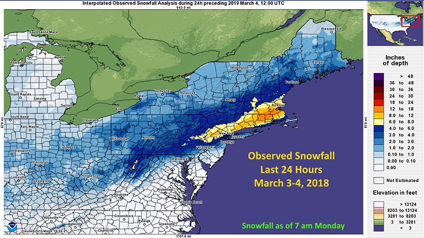
| Figure 4. Observed snowfall during the 24-hour period from 7 am EST Sunday, March 3, to 7 am Monday, March 4, 2019. Map does not include snow that fell after 7 am Monday. Image credit: NWS. |
Major snowstorm wallops Northeast U.S.
The same storm system that spawned Sunday’s deadly Alabama tornadoes also brought one of the heaviest snowfalls of the winter to portions of the Northeast U.S. Over a foot of snow fell over Connecticut, northern Rhode Island, and southeast Massachusetts. Officially, 9.8” was recorded at Boston’s Logan Airport, with many outlying areas of Boston receiving 15”. New York City received 5”. On Monday morning, nearly 60,000 customers in the Northeast were without power, including more than 14,000 in Massachusetts.
The storm also brought heavy snow to Colorado over the weekend, where a 12-mile stretch of Interstate 70 west of Frisco was closed for several hours on Saturday after multiple accidents, some with injuries, KUSA reported. The station said the Denver Police Department reported 20 crashes in one hour Saturday night. On Sunday, an avalanche sent a plume of snow over a section of I-70 between Frisco and Copper Mountain (see tweet below). Fortunately, no one was injured in the avalanche. Loveland Pass on I-70 recorded 20” of snow from the storm.
WOW! This is terrifying! Just got this video from the view of a car going eastbound on I-70 yesterday around 5 p.m. Thankfully, no cars were buried. No one was hurt. #cowx pic.twitter.com/OOiy5mEvN9
— Marshall Zelinger (@Marshall9News) March 4, 2019
In an unusual twist, Denver saw its coldest day of the winter three days after the end of meteorological winter. Denver’s high of 6°F on Sunday was the city’s first single-digit high since Jan. 5, 2017.
Dr. Jeff Masters wrote the snow-related portion of this post.


