| Above: Simulated radar reflectivity and surface pressure at 20Z (3 pm CDT) Saturday, April 13, 2019, as projected by the 12Z Friday run of the 3-km NAM model, which has high enough resolution to allow for thunderstorms to emerge in the model. Multiple lines of storms and supercells, some severe, are expected to cover a large area by Saturday afternoon. Image credit: tropicaltidbits.com. |
Fast-moving supercell thunderstorms could produce strong, long-track tornadoes on Saturday across northern and central Louisiana, far northeast Texas, southern Arkansas, and western Mississippi. In its midday Friday outlook valid Saturday, the NOAA/NWS Storm Prediction Center placed this region in a moderate risk for severe weather, the second highest of SPC’s five risk categories.
Update (11:40 AM CDT April 13): SPC's late morning Day 1 outlook on Saturday keeps roughly the same area in a moderate risk, as shown in the updated Figure 1 below. The biggest concern for strong tornadoes is with supercell storms that develop on Saturday afternoon, especially over northern and central Louisiana. See the weather.com article for frequent updates on Saturday's volatile weather situation.
 |
| Figure 1 (updated). A large part of the south central U.S. is at a moderate risk of severe weather, the second highest of the risk categories, on Saturday, April 13, 2019. Shown here is the outlook for Saturday issued at 11:12 am CDT. Image credit: NOAA/NWS/SPC. |
The setup has many hallmarks of a dangerous tornado outbreak. Two of the biggest:
Very strong wind shear. The southwest end of the upper-level trough that led to this week’s intense Midwest blizzard was hanging back across the Southwest on Friday. This bundle of energy will evolve into a potent upper low that will move quickly across Texas on Saturday, providing atmospheric uplift to help generate severe storms. Just ahead of the upper low, strong southwest winds at upper levels will rip across the tornado threat area. Near the surface, a rapidly developing surface low will charge across Texas on Saturday morning and through southern Arkansas by Saturday night.
The contrast between southerly surface winds and much stronger southwest winds just aloft will lead to strong wind shear and very high helicity (a measure of how changes in wind speed and direction with height might allow a thunderstorm to rotate).
Unstable low-level air. A tropical air mass will surge across far east Texas and Louisiana on Saturday morning. Precipitable water (the amount of moisture in a column of air, if squeezed to the surface) is predicted to soar as high as 1.50”- 1.75”, not far from record territory for April. Surface dewpoints near 70°F and temperatures of 75-80°F will make for high relative humidity and a very unstable air mass, especially as colder air aloft sweeps in above the warm, humid surface air.
Especially concerning from the tornado standpoint is the high low-level humidity, as this means rising air will condense to form thunderstorm bases at very low heights. The enhanced updrafts at cloud base will coincide with strong helicity to enhance rotation that could help spawn tornadoes.
The best-case outcome for Saturday afternoon would be that enough thunderstorms develop quickly enough ahead of the squall line to inhibit the formation of tornadic supercells, as the numerous storms would tend to compete with each other. The lack of a strong “cap” of warm, dry air several miles high will allow storms to develop more readily than is sometimes the case. Even in this scenario, we would still expect widespread severe weather, including torrential rain, very strong bursts of wind, large hail, and the potential for tornadoes.
The severe storms will likely morph into a powerful squall line by late Saturday, moving across Mississippi and western Tennessee and into Alabama by early Sunday. Tornadoes may still be embedded in segments of this line well into the night, and damaging straight-line winds could be widespread.
Another round of severe weather is expected on Sunday from large parts of the Ohio Valley southward. SPC has outlooked an area straddling the Appalachians with an enhanced risk (the third of the five risk categories). High winds are expected to be the main threat, but tornadoes will be possible, perhaps just west of the Appalachians across eastern Ohio, Kentucky, and Tennessee on Sunday afternoon.
 |
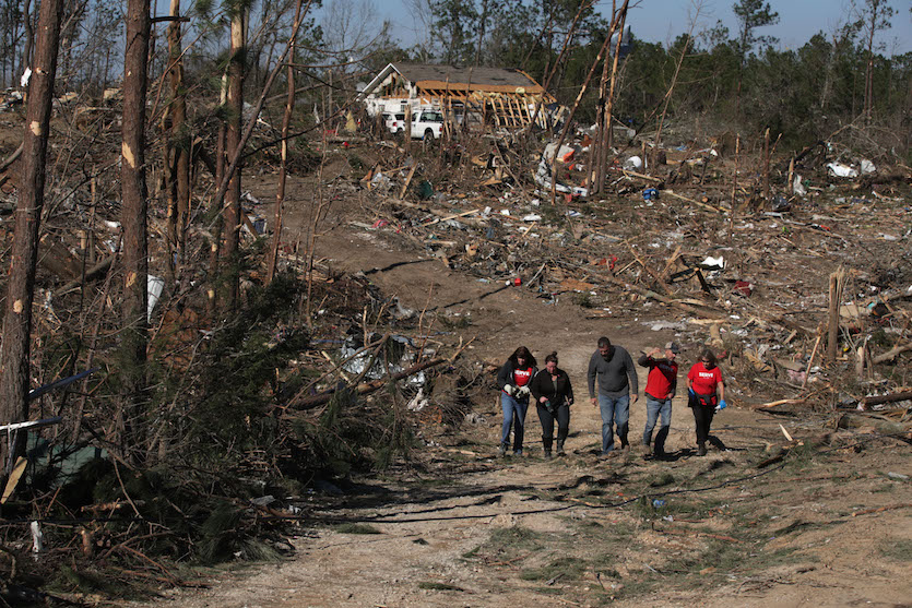
| Figure 2. On March 6, 2019, volunteers and residents walk through one of the areas near Beauregard, Alabama, that was hard hit by a March 3 tornado that killed 23 people. Image credit: Alex Wong/Getty Images. |
The risk to mobile and manufactured homes in a tornado outbreak is very real
As we discussed in a post on April 5, mobile and manufactured homes are especially dangerous places to be during a severe weather outbreak like this weekend’s—especially if their anchors to the ground are insufficient, corroded, or entirely absent, as was the case for the homes involved in 19 of the 23 fatalities in a March 3 tornado that hammered southeast Alabama. If you or a loved one lives in a mobile or manufactured home in the risk areas for Saturday and Sunday, especially in and near northern Louisiana, now is the time to consider an alternate place of shelter.


