| Above: Evacuees from Tropical Storm Imelda who were housed in the First Baptist Church in Hamshire are moved by the Cajun Army to Fannett on September 20, 2019, in Beaumont, Texas. As Imelda weakened to a tropical depression, the storm and its remnants dumped more than 40” of rain across parts of far southeast Texas. Image credit: Thomas B. Shea/Getty Images. |
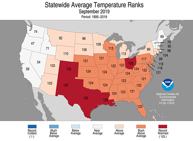
Stoked by record-dry conditions in the Southeast, last month was tied as the second warmest September in records for the contiguous U.S. going back to 1895, NOAA reported on Tuesday. The month was on par with September 2015 and came in behind only the warmth of September 1998.
The heat was widespread, with no states significantly cooler than average. Five states had their hottest September on record—Colorado, Louisiana, New Mexico, Ohio, Texas—and 24 states had a top-five hottest September, covering most of the nation east of the Rockies and south of the Great Lakes and mid-Atlantic.
 |
| Figure 1. Statewide rankings for average temperature for September 2019, as compared to each September since records began in 1895. Darker shades of red indicate higher rankings for heat, with 1 denoting the coldest month on record and 125 the warmest. Image credit: NOAA/NCEI. |
In NOAA data available through September 26, the month had seen a preliminary total of 2655 daily record highs broken or tied across the 50 states, compared to 85 daily record lows—a ratio of roughly 31 to 1. Many more heat records were set in the final four days of the month, as exceptional warmth covered much of the central and eastern U.S. leading into October.
Evening temperatures were consistently high in many of the hardest-hit areas. The temperature at Dallas-Fort Worth International Airport stayed at or above 72 degrees for the entire month, except for the first day of the month, which hit a low of just 71 degrees. The typical daily low at DFW by the end of September is 62 degrees.
More than 100 cities nationwide had a top-three-warmest September, and more than 50 U.S. locations—ranging from Utqiagvik (Barrow), Alaska, and Hilo, Hawaii, to Colorado Springs, Colorado, and Tupelo, Mississippi—experienced their warmest September on record, as detailed by weather.com.
 |
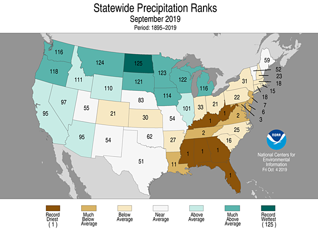
| Figure 2. Statewide rankings for precipitation for September 2019, as compared to each September since records began in 1895. Darker shades of green indicate higher rankings for moisture, with 1 denoting the driest month on record and 125 the wettest. Image credit: NOAA/NCEI. |
Stark moisture contrasts from northwest to southeast
An upper-level pattern that ruled most of September brought unusually wet conditions from the West to the Northern Plains and Great Lakes, while keeping the Southeast and mid-Atlantic starved for moisture. Last month was the driest September on record in six states—Alabama, Florida, Georgia, Kentucky, Mississippi, and West Virginia—and a top-five driest in nine states, including Maryland, Tennessee, and Virginia.
A number of cities from the Southern Plains to the Southeast had both their hottest and driest Septembers on record, including Dallas–Fort Worth and New Orleans. The extremely dry weather in much of the South allowed the ground to dry out and heat up more easily, which helped record heat to build and persist.
In contrast, North Dakota had its wettest September on record, and a total of five states—including Montana, South Dakota, Minnesota, and Wisconsin—had a top-five wettest September.
Ironically, the red-letter rainfall event of the month, Tropical Storm Imelda, occurred in what was otherwise the drier half of the nation. Although its winds only reached 40 mph, slow-moving Imelda brought torrential rains and massive flooding to southeast Texas, especially along and near the heavily populated corridor from Houston to Port Arthur. Several storm totals exceeded 40”, including 43.39” at North Fork Taylors Bayou—the fifth heaviest total on record from any tropical cyclone in the contiguous United States. Though Imelda’s rain footprint was almost as intense as Hurricane Harvey's, it was fortunately much smaller.
Storms like Imelda are becoming more common in our warming climate, as landfalling U.S. hurricanes move more slowly and dump ever-larger amounts of rain onto heavily developed areas.
 |
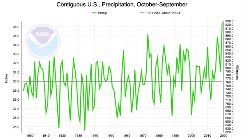
| Figure 3. Precipitation totals for 12-month spans from October to the following September, going back to 1895. The span from October 2018 to September 2019 trounced the previous record for all Oct-to-Sept. periods. Image credit: NOAA/NCEI. |
The last 12 months were by far the wettest October-to-September period on record, with 36.45” far outpacing the old record of 35.15” from 1972-73. This is mainly due to the extreme wetness that characterized the period from fall 2018 through spring 2019. The period from October 2018 to September 2019 ranks fifth among the 1486 overlapping 12-month spans going back to January 1895:
37.86" July 2018–June 2019
37.73” August 2018–July 2019
37.68” June 2018–May 2019
37.55” September 2018–August 2019
36.45” October 2018–September 2019
36.20” May 2018–Apr. 2019
35.95” May 2015–Apr. 2016
35.78” Apr. 2015–Mar. 2016
35.73” Mar. 2018–Feb. 2019
35.63” Feb. 1973–Jan. 1974
Amazingly, the nine wettest of these 12-month spans have all occurred in the last six years. Even given the fact that a very wet span of a few months will be factored into such listings more than once, this is still remarkable testimony to the power of our warming climate to make extreme rain events even more extreme.


