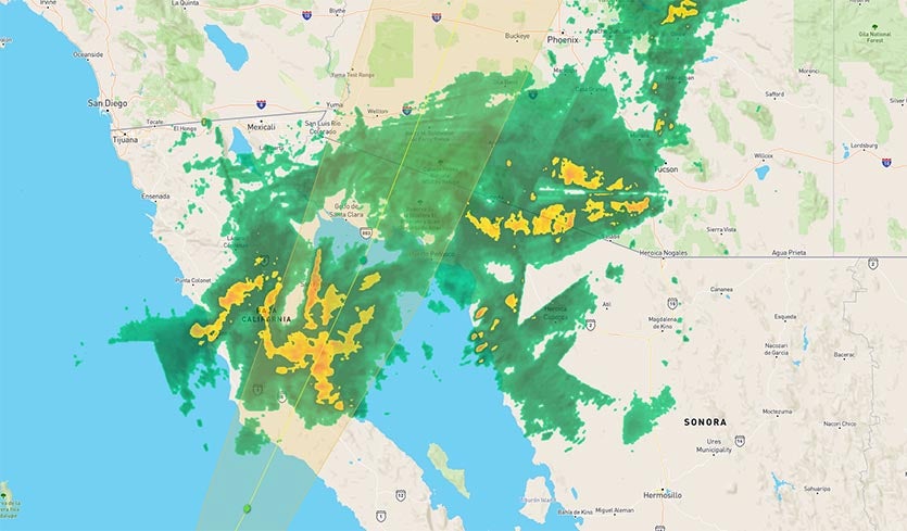
| Above: Radar image of Tropical Storm Rosa at 11:45 am EDT October 1, 2018, from our wundermap with Rosa’s projected track overlaid. |
Flash flood watches are posted for most of Arizona, Utah, southeast Nevada, and southeast California through Tuesday night as moisture from Tropical Storm Rosa sweeps inland. Rosa was weakening quickly on Monday afternoon due to high wind shear and cool waters as it steamed north-northeastwards at 12 mph towards the northern portion of Mexico’s Baja Peninsula. The center is likely to cross the coast of northern Baja late Monday afternoon. Rosa’s top winds were down to 45 mph at 11 am EDT Monday, and the storm is expected to weaken to a tropical depression on Monday night. One other named storm has made landfall in Mexico in 2018—Tropical Storm Bud, which made landfall near the tip of the Baja Peninsula on June 14.
 |
| Figure 1. GOES-17 visible image of Tropical Storm Rosa at 12:10 pm EDT October 1, 2018. Image credit: NOAA/RAMMB. |
Rosa was already spreading a large area of heavy rain inland on Monday morning, triggering a flash flood warning in southern Arizona near Bosque. Radar-estimated rainfall rates of 2 – 3 inches per hour were occurring in Rosa’s strongest thunderstorms near the Mexico/Arizona border, as seen on the Yuma, AZ radar. As of 9 am MDT, Ajo, AZ had recorded a 24-hour rainfall amount of 2.29”.
 |
| Figure 2. Precipitation forecast for Rosa for the 3-day period 8 am EDT Monday, October 1 through 8 am EDT Thursday, October 4, 2018. A swath of 2 – 4” of rain was predicted from southern to central Arizona. A separate zone of heavy rain, triggered by an offshore midlatitude storm helping to steer Rosa, will dump 1 – 2” of rain over parts of the Southern and Central California coast and foothills on Tuesday and Wednesday. Here, too, the showers and thunderstorms will be a mixed blessing: they will help reduce the autumn fire threat, but rains falling atop burn scars from 2017 could lead to localized flash flooding. Image credit: NOAA. |
The 6Z Monday run of the GFS model predicted that on Tuesday morning precipitable water (the amount of moisture above any one spot) would be near or above record-high levels for October over a number of locations in the Southwest U.S. which launch daily balloon-borne radiosondes, including Yuma and Phoenix, AZ; Las Vegas, NV; and Grand Junction, CO. The National Hurricane Center (NHC) was predicting 3 – 6” of rain for Baja California and northwestern Sonora, Mexico, 2 – 4” for Central and Southern Arizona (with isolated 6” amounts in the mountains of Central Arizona), and 1 – 2” (with isolated 4” amounts) for the rest of the Desert Southwest, Central Rockies, and Great Basin. On the positive side, the entire Southwest is in drought, so Rosa’s rains will do much to ease the drought conditions there.
 |
| Figure 3. U.S. drought conditions as of September 27, 2018. Rosa’s heavy rains will be falling over regions in moderate to extreme drought. Image credit: USDA/University of Nebraska-Lincoln/NOAA. |
An unusually northerly landfall
Rosa will make landfall at an unusually far north location on Mexico’s Baja Peninsula: near 29.5°N latitude, or about 200 miles south-southeast of San Diego. Since accurate record keeping began in 1949, just three tropical storms have made landfall along the west coast of the Baja Peninsula at a more northerly latitude than that: Tropical Storm Kathleen of 1976, Tropical Storm Jen-Kath in 1963, and an unnamed storm in 1951. Unusually warm sea surface temperatures (SSTs), about 1 – 2°C (1.8 – 3.6°F) above average, will help allow Rosa to maintain tropical storm strength to such a northerly latitude. Note that we do have records of two tropical cyclones that have hit California: the 1939 California tropical storm, which hit Long Beach, and the 1858 San Diego hurricane.
 |
| Figure 4. Tracks of all tropical cyclones to make landfall or pass just offshore of the northern Baja Peninsula since 1949. The mostly northerly landfall by a tropical storm on the western Baja Peninsula since 1949 was at 31°N latitude, by Tropical Storm Jen-Kath in 1963. The mostly northerly landfall by a hurricane was by an unnamed 1959 Category 1 hurricane. Note that these stats do not include the 1939 California tropical storm, which hit Long Beach, and the 1858 San Diego hurricane. Image credit: NOAA/CSC. |
Southwest U.S. hurricane history
Southern Arizona experiences flash flooding directly or indirectly associated with a tropical cyclone about once every two years, and a tropical depression or tropical storm moves across southern Arizona about once every five years, according to the National Weather Service in Tucson. Four of the five most serious floods in southern Arizona since 1970 were caused by tropical cyclones. The strongest tropical cyclone recorded in Arizona was Tropical Storm Nora of 1997, which brought sustained winds of 50 – 60 mph to Yuma, and dumped the state’s heaviest 24-hour rainfall in history: 11.97”. Nora is also credited with the state’s heaviest tropical cyclone-related rain event: 12.01” in the Harquahala Mountains (5700’ elevation). The most damaging tropical cyclone to affect Arizona was Tropical Storm Octave of 1983, whose floods killed 14, injured 975, and caused $1.26 billion in damage (2018 dollars).
Leslie could become a hurricane on Tuesday
There’s nothing too earthshaking to report about persistent Tropical Storm Leslie, which continues to spin in the North Atlantic about 600 miles east of Bermuda. The main news of note is that Leslie is slowly gaining strength as it drifts south over warmer waters. Leslie’s top sustained winds were 60 mph as of 11 am EDT Monday. Leslie is predicted by NHC to become the sixth Atlantic hurricane of the year on Tuesday; it may weaken back to tropical-storm strength when it gets tugged northward late this week. None of these changes in strength or location will be dramatic, and the GFS and European models suggest that Leslie will still be roaming the central North Atlantic a week from now.
Time to watch the Caribbean for development
It’s October, a time of year when the western and central Caribbean Sea typically becomes the Atlantic’s most dangerous breeding ground for hurricanes. So far in 2018, the Caribbean has seen high wind shear and limited hurricane activity due to the presence of a strong subtropical jet stream. However, this may change early next week, when the subtropical jet stream is predicted to lift to the north so that it is positioned over Cuba. This will create a region of lower wind shear over the central and western Caribbean, and recent runs of the GFS and European model have been suggesting that a large area of low pressure will form there this weekend. This low will have the potential to develop into a tropical depression early next week, as predicted by over 30% of the 70 ensemble members of the 0Z Monday GFS and European models. The track such a storm might take is anyone’s guess at this point, and we’ll just have to watch how the models depict the evolution of this potential threat in coming days.
 Monday, October 1, 2018") |
| Figure 5. Infrared satellite image of Hurricane Walaka at 1430Z (10:30 am EDT) Monday, October 1, 2018. Image credit: NOAA/NESDIS. |
Hurricane warning for a remote U.S. territory ahead of fierce Walaka
Vaulting from tropical storm to Category 3 strength in just 12 hours, Walaka is roiling the Central Pacific about 900 miles southwest of Honolulu. Satellite images on Monday morning revealed a well-structured and fast-growing hurricane. Top sustained winds were up to 125 mph as of 11 am EDT Monday.
Walaka is in an exceptionally supportive environment for rapid strengthening: wind shear of 5 knots or less, a very moist atmosphere (mid-level relative humidity around 70%), sea surface temperatures of 29 - 30°C (84 - 86°F), and moderate amounts of deep oceanic heat content. Reflecting these conditions, the 12Z Monday run of the SHIPS models gives Walaka unusually high odds of becoming a Category 5 storm, including an eye-opening 64% chance of gaining 40 knots of strength within 24 hours. The NOAA/NWS Central Pacific Hurricane Center is predicting Walaka to hit Cat 5 strength by Tuesday morning.
Walaka’s track forecast for the next several days is fairly straightforward: a sharp right-turn tonight will be followed by a north-northeastward motion from Tuesday onward. On this path, Walaka will pass near or just west of Johnston Island, an uninhabited, unincorporated U.S. territory that’s also a National Wildlife Refuge. CPHC has placed the island under a hurricane warning. It’s entirely possible Johnston Island will experience the right-hand eyewall of a Category 5 hurricane, which could be devastating for the island’s millions of seabirds.
By Wednesday, wind shear will be pushing above 15 knots and SSTs beneath Walaka will be dropping to around 26-27°C (79–81°F), a much less supportive range for a major hurricane. CPHC predicts Walaka to weaken below hurricane strength by Friday, long before it has a chance to affect any land areas.
Walaka’s northward track and intensity have a chilling resemblance to 1992’s Hurricane Iniki, which also turned sharply north and ripped across the Hawaiian island of Kauai as a Category 4 storm. Had Walaka been displaced only about 500 miles to the east, it could have produced a destructive deja-vu experience for Kauai.
A nomenclature note: Walaka is the last name to be used among the 48 storm names that have been used in order for Central Pacific tropical storms and hurricanes (those that develop between 180°W and 140°W) since the list was established by the World Meteorological Organization in 1982. The list is broken into four alphabetized groups of 12, but each year picks up wherever the last year left off. The next storm name for this region will be the one at the top: Akoni, which hasn’t been used in 36 years. Only four names have been retired in the Central Pacific: Iwa (1982), Iniki (1992), Paka (1997) and Ioke (2006)
 Monday, October 1, 2018") |
| Figure 6. Day/night visible-wavelength VIIRS image of Typhoon Kong-ray at 0434Z (12:34 am EDT) Monday, October 1, 2018. Image credit: RAMMB/CSU/CIRA. |
Another potential super typhoon: Kong-rey
Following in the sea-prints of Category 5 Super Typhoon Trami, Typhoon Kong-rey is also gunning for Cat 5 strength along a similar path that could threaten parts of East Asia. Kong-rey’s top sustained winds were estimated at 145 mph by the Joint Typhoon Warning Center as of 8 am EDT Monday. Conditions aren’t quite as optimal for Kong-rey as for Walaka, but the typhoon could easily strengthen to Category 5 levels with wind shear a moderate 10-15 knots, SSTs around 29°C (84°F), and a moist midlevel atmosphere (RH around 70%).
The Kyushu Islands of southernmost Japan are in for yet another battering from a typhoon, as Kong-rey will pass across the southern part of the chain by Thursday. There is some track uncertainty beyond that point, but model consensus suggests that South Korea is most likely to feel the brunt of Kong-rey this weekend as a weakening Category 1 typhoon with torrential rains and a flood threat.
 |
| Figure 7. A woman walks past a fallen sign in Tokyo on Monday, October 1, 2018, in the wake of Typhoon Trami, which struck early Sunday. Image credit: Jiji Press/AFP/Getty Images. |
Meanwhile, Japan is picking up the pieces after a weekend assault from Typhoon Trami that led to at least four deaths, as noted by weather.com. Some 200 injuries have been linked to Trami, according to officials cited by the Japan Times on Monday. Transportation remained in a tangle: more than 1000 flights were canceled, and train lines were carrying out safety checks before resuming normal service. A wind gust to 164 kilometers per hour (102 mph) was reported in Hachioji, part of the western Tokyo metro area.
Dr. Jeff Masters co-wrote this post.
ESA astronaut Alexander Gerst took these images of Typhoon Trami. #Trami #TyphoonTrami pic.twitter.com/BxixnBMvcU
— AstroHardin ♱ (@AstroHardin) September 26, 2018


