| Above: A person walks their dog as smoke blankets the city from nearby wildfires, in Edmonton, Alberta, Canada on Thursday, May 30, 2019. Thousands were forced from their homes during late May as several wildfires raged out-of-control in northern Alberta and blanketed areas to the south in an acrid haze. Image credit: jason Franson/The Canadian Press via AP. |
Tenaciously wet, mild conditions this spring have kept U.S. wildfire acreage at its lowest level in more than a decade of monitoring. It’s great news, to be sure, but tempered by forecasts of an above-average fire threat building through the summer in the Pacific states. And the same pattern that’s given the U.S. a wildfire break has gotten Canada’s fire season off to a rough start.
U.S. crews en route to assist with wildfires in Canada https://t.co/pwnvVcvSTC pic.twitter.com/qe74RJmAqP
— Wildfire Today (@wildfiretoday) June 4, 2019
Daily statistics released on Friday by the National Interagency Fire Center (NIFC) showed that 15,963 wildfires had been tallied in the 50 U.S. states from January 1 through June 7. That’s the lowest year-to-date total in the ten years of data made available by NIFC, and it compares to a 10-year average through this date of 25,911 fires.
What’s more, these fires have trended toward the smaller side. A total of 332,791 U.S. acres had burned through June 7. That compares with the previous year-to-date low of 345,194 acres in 2013, and it’s a mere 24% of the 10-year average through this date of 1,415,399 acres.
No rocket science is needed to figure out why the U.S. has had so little fire activity this year. As discussed in our last post, the year through May has been the wettest in 125 years of data for the contiguous U.S., and the last 12 months have been the wettest-year long span on record.
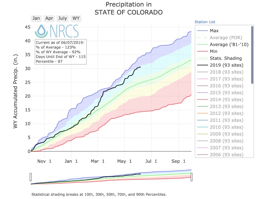
Temperatures have also leaned cool in many locations, helping the landscape to stay moist and prolonging the melt-out of a generous snowpack across much of the West. On Friday, June 7, the Great Basin was reporting close to seven times the usual amount of snowpack (snow water equivalent) for this late date, according to SNOTEL data, and California had more than five times its average June 7 snowpack. Total precipitation since October (water year 2019) was running at 130% of average for the Great Basin, 125% for California, and 123% for Colorado. Only the Pacific Northwest and northern Idaho are running below average in water-year precipitation, with Washington the lowest at 83%.
 |
| Figure 1. Cumulative precipitation since October 1 in Colorado (black line) as compared to the 1981-2010 average (green line) and percentile ranges (shaded). As of June 7, total precipitation for the water year since October 1, 2018, was at 123% of average, putting it close to the top 10% of all years on record. Image credit: USDA Natural Resources Conservation Service. |
What spring tells us about summer fire risk
In some areas, the wet, cool spring bodes well for a reduced fire threat that can extend throughout the summer. Colorado is a good example. According to NIFC, all but one of the years since 1992 that saw above-median Colorado snowpack on June 1 experienced lower-than-average large-fire activity in the subsequent June-through-August period from the Front Range westward.
In some other parts of the West, especially where summers run hot and dry, a wet spring can set the stage for abundant vegetation that dries out and leads to heightened fire risk later in the summer.
Wildfire expert and author Stephen Pyne (Arizona State University) told me he adheres to two principles when considering the upcoming fire season:
(1) “The rhythms of fire regimes follow the rhythms of wetting and drying. It has to be wet enough to grow fuels, then dry enough for them to burn. Normally wet places (e.g., mountain forests) burn during droughts. Normally dry places (e.g., deserts) burn after wet spells. This has been a mostly wet winter and spring in the West”
(2) “Both moisture and heat are exchanged across surfaces, so fuel particles that have high surface-to-volume ratios respond to weather quickest, burn fastest, and drive the firefront. In the absence of drought, the small stuff will determine the fire season.”
Overall, Pyne expects there will be relatively few explosive fire starts in the higher terrain of the West, barring any high-wind episodes, with the fire risk focused more on lower-elevation grasslands and shrublands. “I would expect fires along the California foothills, the Great Basin, the Desert Southwest, and maybe the Columbian [River] plain,” Pyne said in an email. “Depending on the summer rainy season, big burns may or may not come by August and September.”
 |
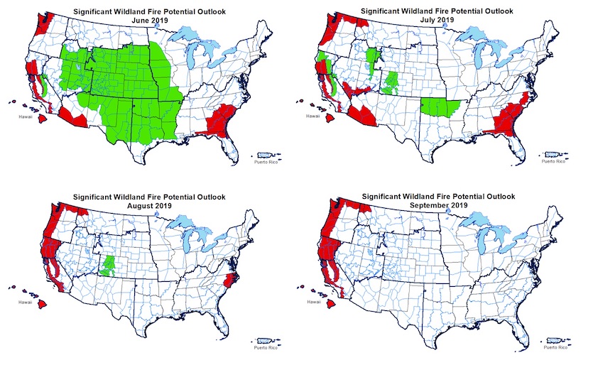
| Figure 2. Wildfire outlooks for June through September 2019, as updated on June 1. Heavy rains from this weekend into next week could reduce the fire threat depicted across the Southeast for June. Fire potential in Alaska (not shown) is expected to be near normal throughout the period. Image credit: NIFC Predictive Services. |
In the June 1 monthly update to its 2019 fire outlook (above), NIFC touched on similar themes. An expansive area of below-average fire potential in June, extending from the Great Basin to the Mississippi Valley, largely disappears in August. Above-average fire potential in June is limited to the edges of the contiguous U.S., including parts of Georgia and South Carolina, southern Arizona, the California Coast Range, and far western Washington.
By August and September, above-average potential expands to cover the coastal ranges and adjacent valleys throughout the Pacific States, as well as the Sierra Nevada and far northern Washington and Idaho. These areas normally see a ramp-up in fire risk by late summer, so what’s being predicted is a threat above and beyond the seasonal routine.
NIFC’s outlook is based in part on expectations of somewhat warmer-than-average summer temperatures west of the Continental Divide, especially toward the West Coast, with the North American Monsoon potentially weaker, later, and further east than usual.
In Alaska, wildfire potential is expected to be near normal, despite persistent extreme drought in the southern Alaska Panhandle.
 |
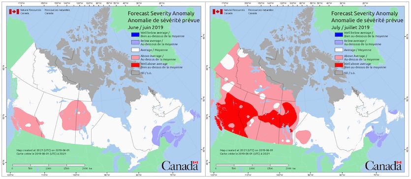
| Figure 3. Fire weather severity anomaly predicted by the Canadian Government on June 1, 2019, for June (left) and July (right) by Environment Canada. These maps show the ratio of the forecasted severity rating to the average monthly or seasonal severity rating. Image credit: Natural Resources Canada. |
The dry conditions in far southeast Alaska hint at a much broader pattern that’s been shaping North American wildfire risk. Since February, the main polar jet stream has often been displaced well south of its usual latitude, running from the Pacific into the Southwest U.S. as late as May and leading to frequent chilly, damp periods. Another branch of the jet has been arcing well north across northwest Canada, leaving much of western Canada mild and dry. This topsy-turvy pattern has shunted much of the early-season wildfire risk well into Canada.
 |
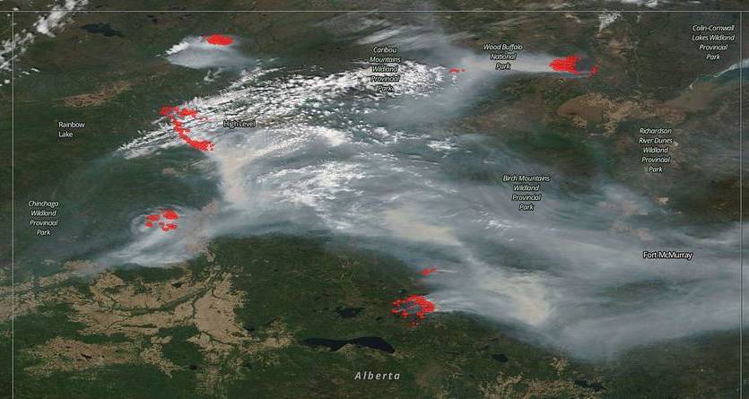
| Figure 4. The northern part of Canada’s Alberta province was pockmarked with wildfires on May 29, as seen in this natural-color satellite image collected by the Moderate Resolution Imaging Spectroradiometer (MODIS) aboard the Terra satellite. Four of the five fires visible here were in zones of extreme fire danger. Image credit: NASA. |
As of May 22, wildfires in Alberta had scorched about 134,000 acres, roughly 24 percent above the five-year average for that period, according to provincial government data reported by the Toronto Globe and Mail. More than 10,000 Albertans have been forced to evacuate.
Smoke from the fires has been blowing across parts of the Midwest this week, reducing air quality but producing vivid red sunsets.


